Welcome to the Virtual Base Camp!
This is the starting point for your exploration of the polar regions with PolarTREC teachers and researchers!
PolarTREC expeditions to the Arctic and Antarctica can be found here starting in 2007 to present. You can also access archived expeditions to the Arctic that took place through TREC in 2004-2006. Journals, photos, ask the team forums, and information about each expedition can be found by following the links to all the expeditions. Use the Expedition Search feature to narrow your choices or find a particular expedition or region. Use the Members feature to find teachers and researchers involved with PolarTREC expeditions.
Another interesting perspective for viewing expeditions are Projects. Projects are expeditions that had teachers for more than one year. You can learn more about the science and see all the teachers and researchers involved in the research project over two or more years. You can also access all the related project resources (presentations, lessons, PolarConnect events, etc.) related to the projects.
2020-2021 PolarTREC Expedition Update
We are excited to announce that in 2021, we will be able to support a few PolarTREC expeditions! The details are still emerging but we will share the updates as we get them. COVID-19 continues to impact us all and that includes polar research. We will continue to monitor the situation and respond accordingly. Our priority is for the safety of the teams and the communities of which they would visit. Most of the deployments for the 2020 PolarTREC educators to both the Arctic and Antarctica continue to be postponed until 2022. Consequently, all the original field dates have been changed to reflect 2021 in the Virtual Base Camp.
2021 Expedition Timeline
Expeditions
Phenology and Vegetation in the Warming Arctic 2021
What Are They Doing?
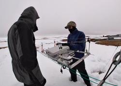 Steve Oberbauer and Jeremy May set up the Mobile Instrumented Sensor Platform (MISP) tram. Utqiaġvik, Alaska. Photo by Alejandra Martinez.
The goal of this expedition is to understand arctic terrestrial change by monitoring vegetation communities in northern Alaska associated with the International Tundra Experiment Arctic Observatory Network (ITEX-AON). The team will study environmental variability and increased temperature on tundra plant phenology, growth, species composition and ecosystem function.
The ITEX network works collaboratively to study changes in tundra plant and ecosystem responses to experimental warming. The network monitoring sites are located across many major ecosystems of the Arctic. This project will provide urgently needed data critical to understanding the impact of multi-scale vegetation change on ecosystem function, namely land-atmosphere carbon and water fluxes and energy balance.
Expedition Map
High Arctic Change 2021
What Are They Doing?
The Svalbard Archipelago has an arctic climate and is home to several large bodies of ice - alpine glaciers in the mountains, and tidewater glaciers that descend into the sea. Svalbard is currently undergoing rapid climate change with the dramatic retreat of its tidewater glaciers.
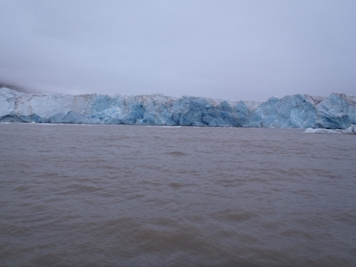 A view in front of Kronebreen Glacier. Ny Ålesund, Svalbard, Norway. Photo by Mark Goldner (PolarTREC 2011), Courtesy of ARCUS.
The goal of the research is to gain a deeper understanding of ice-ocean interactions and processes at the faces of tidewater glaciers. This important research will increase our knowledge of climate change and tell the visual story - in particular, this research will further our understanding of ice retreat rates and the impact on sea level rise in the future.
Tidewater glaciers are among the fastest-changing systems in the Arctic, and the dynamic Kronebreen glacier is situated a short distance from the scientific research base of Ny Ålesund at 79°N latitude. In particular, the team will investigate how climate change affects sediment transport and deposition associated with the tidewater glaciers, icebergs, meltwater streams, and marine currents.
The summer ice mélange at the ice face in these smaller systems is flushed out rapidly making it possible to work safely from small boats at a distance (between 200m to 2 km) from the calving ice face. Our proposed work follows on our earlier observations that warm North Atlantic Water is impacting the ice face more today than seen in 2005, 2009, 2011, and 2014, increasing retreat rates. Over these years, we have observed different meltwater plumes turning on and off on a daily to weekly basis. Funded by National Geographic, we have planned the science to add observations to other aspects of the glacial system being monitored by Norsk Polar scientists (Jack Kohler, Katerine Husmin, et al).
The team will be mapping bathymetry of the ice margin area to compare with earlier surveys, and recording oceanographic data (including temperature, salinity, and turbidity of the water column) to track the inflow of North Atlantic water at the ice face. They are particularly interested in monitoring the position and velocities of subglacial jets as they exit the glacier and enter the fjord. The team will also record and monitor iceberg calving at the glacier face.
Beyond the science, public outreach using science and imagery will be used to communicate to the public critical climate change issues, exposing them to the challenges and rewards of conducting high latitude research. Public outreach will showcase arctic processes and how what happens in the Arctic high latitudes impacts coastal resiliency.
Expedition Map
Nansen and Amundsen Basins Observational System
What Are They Doing?
 Deployment and recovery of moorings
Research is carried out through the NABOS (Nansen and Amundsen Basins Observational System) program. The goal of this study is to develop a comprehensive and quantitative understanding of how the Eastern Eurasian Basin (EEB) functions as a switchgear, accumulating and releasing major Arctic riverine transports and redistributing ice and freshwater between the eastern and western Arctic in response to atmospheric and oceanic forcings. Three biennial cruises, planned for August-September, will take measurements between Franz Josef Land and the central East Siberian Sea, following a path that moves from shallow water to the deep sea. The sampling program connects observations using moorings, ship sampling, and drifters.
Expedition Map
Thermal Sensitivity of Embryos and Larvae of Antarctic Marine Ectotherms 2021
What Are They Doing?
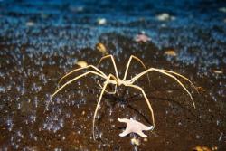 A giant sea spider towers over a field of polyps at Turtle Rock, Antarctica. Photo by Timothy R. Dwyer.
Cold-blooded animals in the Antarctic ocean have survived in near-constant, extreme cold conditions for millions of years and are very sensitive to even small changes in water temperature. However, the consequences of this extreme thermal sensitivity for the energetics, development, and survival of developing embryos is not well understood.
This project will investigate the effect of temperature on the metabolism, growth rate, developmental rate, and developmental energetics of embryos and larvae of Antarctic marine ectotherms. The project will also measure annual variation in temperature and oxygen at different sites in McMurdo Sound, and compare embryonic and larval metabolism in winter and summer to determine the extent to which these life stages can acclimate to seasonal shifts. This research will provide insight into the ability of polar marine animals and ecosystems to withstand warming polar ocean conditions.
Expedition Map
Antarctic Automatic Weather Stations 2021
What Are They Doing?
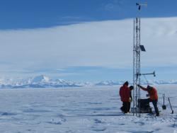 The team raises meteorological instrument equipment onto the Sabrina Automatic Weather Station (AWS), Antarctica. Photo by David Mikolajczyk, Courtesy of Michael Penn.
The Antarctic Automatic Weather Station (AWS) network has been making meteorological observations since the early 1980s. This continent-wide network is positioned to observe significant meteorological events and increase our understanding of the climate of the Antarctic surface. Researchers utilize the AWS network to observe and learn about the Antarctic in a warming world. Given the duration of the AWS program and maintaining AWS sites for many years, numerous studies have been conducted on the surface climatology of regions of the continent, such as the Ross Ice Shelf. This climatology also aids in other studies, like winter warming events.
The Antarctic Automatic Weather Station network provides a greater understanding of the surface meteorology and climatology throughout the continent of Antarctica. The AWS network spans the Ross Ice Shelf, Ross Island, West Antarctica, East Antarctica, and the South Pole. Since some of the AWS have been working for over 30 years, we can begin to understand the climate over many regions of Antarctica.
Expedition Map
IceCube and The Askaryan Radio Array 2021
What Are They Doing?
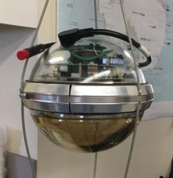 A Digital Optical Module (DOM) hanging in the IceCube Lab at the Amundsen-Scott South Pole Station, Antarctica. Photo by Kate Miller.
IceCube is located at the South Pole and records the interactions of a nearly massless sub-atomic messenger particle called the neutrino. IceCube searches for neutrinos from the most violent astrophysical sources: events like exploding stars, gamma ray bursts, and cataclysmic phenomena involving black holes and neutron stars.
The IceCube Neutrino Observatory is a powerful tool to search for dark matter, and could reveal the new physical processes associated with the enigmatic origin of the highest energy particles in nature. In addition, IceCube studies the neutrinos themselves using the 100,000 neutrinos detected per year produced by cosmic rays in the atmosphere. Their energies far exceed those from accelerator beams. IceCube encompasses a cubic kilometer of instrumented ice, and is the largest detector by volume ever built.
The fully built ARA project, also located at the South Pole, will have an effective volume 100 times bigger than IceCube. The trade off is that it is only capable of observing radio waves from extremely high energy neutrinos, a million times more energetic than the neutrinos produced by cosmic rays in the atmosphere. This neutrinos are extremely rare, which is why such a large detector is needed to increase the chance of seeing one.
Expedition Map
Dry Valleys Ecosystem Study 2021
What Are They Doing?
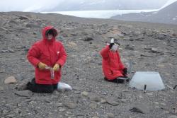 Dr. Thomas Powers and Natasha Griffin collect soil samples at the F6 site in the McMurdo Dry Valleys, Antarctica. Photo by Kevin Dickerson.
The McMurdo Dry Valleys Long-Term Ecological Research (MCM LTER) Program is an interdisciplinary and multidisciplinary study of the aquatic and terrestrial ecosystems in an ice-free region of Antarctica. MCM joined the National Science Foundation's LTER Network in 1993 and is funded through the Office of Polar Programs in six year funding periods.
The McMurdo Dry Valleys (77°30'S 163°00'E) on the shore of McMurdo Sound, 2,200 miles (3,500 km) due south of New Zealand, form the largest relatively ice-free area (approximately 4,800 sq km) on the Antarctic continent. These ice-free areas of Antarctica display a sharp contrast to most other ecosystems in the world, which exist under far more moderate environmental conditions. The perennially ice-covered lakes, ephemeral streams and extensive areas of exposed soil within the McMurdo Dry Valleys are subject to low temperatures, limited precipitation and salt accumulation. The dry valleys represent a region where life approaches its environmental limits, and is an end-member in the spectrum of environments included in the LTER Network.
The overarching goal of MCM LTER research is to document and understand how ecosystems respond to environmental changes.
Expedition Map
Warming and Removals in Mountains of Northern Canada
What Are They Doing?
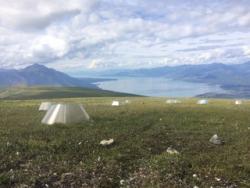 Warming chambers in alpine tundra near Kluane Lake, Yukon, Canada. Photo by Jennie McLaren.
The impacts of global climate warming will be disproportionately felt in arctic and montane ecosystems. There is high risk of these ecosystems releasing their large soil carbon (C) stores with climate warming, positively feeding back to rising atmospheric C. One of the fundamental challenges facing global change research is predicting changes in species distributions and ecosystem functions in response to warming. I propose an experiment which enables the simultaneous study of the direct and indirect effects of warming on ecosystem functioning in northern alpine ecosystems. This type of research has been repeatedly called for to determine how changes in species composition and climate warming will influence biodiversity and ecosystem dynamics.
Few warming experiments occur in alpine, as opposed to arctic tundra, despite the importance of alpine tundra as a C sink, as well as the global distribution of these ecosystems. We will provide a dataset to the tundra warming literature with ecosystem characteristics unique to montane environments, including responses by both the plant and microbial communities, as well as changes in ecosystem C dynamics.
This project will also contribute to a globally-distributed montane ecosystem warming research program. Collaborative networks such as these are essential for examining the context dependent nature of responses to environmental change and will improve our ability to predict responses across ecosystems to climate change.
Expedition Map
Harmful Algal Blooms in Arctic Waters
What Are They Doing?
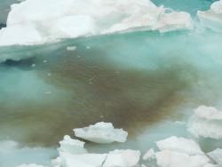 Ice algae in the northern Chukchi Sea. Photo by Sandra Thornton.
As ocean temperatures warm, in particular the shallow Chukchi Sea, many organisms may spread into Arctic waters. Some of these present significant threats to human and ecosystem health, such as harmful algal bloom (HAB) species (commonly called red tides). The potent neurotoxins that these species produce can affect marine mammals, seabirds, and other resources critical to subsistence harvesters.
At the same time, little is known about the present and future risk from toxic algae to humans in the Pacific Arctic region. This study will be the first to document the current distribution of highly toxic HAB species over large spatial scales within the Alaskan Arctic and will provide estimates of areas at high risk of toxicity now and in a warming future. The hypothesis underlying this project is that HABs in Alaskan Arctic waters are not only transported from the south through Bering Strait but are now originating locally on the Chukchi shelf due to warming temperatures, circulation dynamics, and water mass structure. These factors influence bloom magnitude, duration, toxicity, and recurrence. This will be addressed through a joint physical-biological field and laboratory program to study the relationship between HAB species distribution/dynamics and the physical environment of the Chukchi Sea region.
The distribution of HAB species on the Chukchi shelf will be mapped in relation to hydrography and circulation, including a comprehensive survey of the Alaskan Coastal Current which transports the warmest water in the Chukchi Sea. A range of molecular and physiological tools will be used to investigate the origin, connectivity, and fate of HAB populations in the region. Sediment profiling will establish a historical record of blooms along the major transport pathways to the western Arctic. This information will be used to generate conceptual models of the origin, transport, and fate of HABs in the Chukchi Sea region.
Expedition Map
Education, Knowledge, and the Narwhal
What Are They Doing?
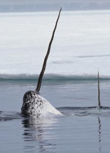 Isumaqatingniq, the Inuktitut word for expressing, “thinking together” describes the process proposed for our educational collaborative to integrate knowledge frames of traditional Inuit knowledge and STEM. Inuit Qaujimajatuqangit (IQ), or Inuit knowledge literally translates in Inuktitut to mean “a way of knowing” and science are two ways of knowing the natural and physical world. Both have a useful, complimentary, and insightful methodology. Holders of IQ and scientists are learning to better understand the benefits of each knowledge frame, though seldom do they fully appreciate the discipline or practice of the other, and even less often do they actively integrate these two knowledge approaches. More importantly, future generations of children from Inuit and other First Nations groups rarely have a welcoming entre into scientific studies through their oral tradition of IQ. Similarly, students in countries adopting scientific study or STEM as part of their core curriculum, rarely get introduced to IQ or other knowledge perspectives until pursuing more advanced studies in social science. This study will bridge these systems of thought and knowledge models through educational settings, by establishing baseline content during workshops with Inuit and non-Inuit elders, hunters and experts representing both knowledge frames as they apply to the study and knowledge of the narwhal. Print and Video educational modules will be prepared as an educational adjunct for science courses directed initially for high school students and a joint presentation with representative students from each group during United Nations Indigenous Day, October 12th, 2020.
Expedition Map
Greenland Subglacial Tremor Project
What Are They Doing?
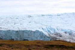 The Greenland Ice Sheet near Kangerslussuaq, Greenland. Photo by Tina Ciarametaro.
Estimates of the Greenland ice sheet's contribution to sea level rise over the next century range from a few centimeters to over one meter. Differences of a few millimeters per year may be significant in lowlying, populous coastal areas where planning with such a large range of uncertainty has high economic and social costs for governments, communities, and businesses. This study will improve our understanding of how increases in surface runoff will influence ice flow and subsequent loss of water mass from the Greenland ice sheet to the oceans.
Expedition Map
International Arctic Buoy Program
What Are They Doing?
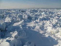 Land-fast sea ice is fastened along the shoreline in Utqiaġvik, Alaska. Photo by John Wood.
The participants of the International Arctic Buoy Program (IABP) work together to maintain a network of drifting buoys in the Arctic Ocean to provide meteorological and oceanographic data for real-time operational requirements and research purposes including support to the World Climate Research Programme (WCRP) and the World Weather Watch (WWW) Programme. Data from the IABP have many uses. For example: 1. Research in Arctic climate and climate change, 2. Forecasting weather and ice conditions, 3. Validation of satellites, 4. Forcing, validation and assimilation into numerical climate models, and 5. Tracking the source and fate of samples taken from the ice. Over 1000 publications have benefited from observations from the IABP.
Sarah and the team will be headed out for a second deployment to Greenland in June-July 2020.


