Welcome to the Virtual Base Camp, the starting point for your exploration of the polar regions with PolarTREC teachers and researchers!
2013 Expedition Timeline
Expeditions
Airborne Survey of Polar Ice 2013
What Are They Doing?
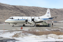 NASA's P-3 Orion IceBridge Aircraft
IceBridge, a six-year NASA mission, is the largest airborne survey of Earth's polar ice ever conducted. IceBridge uses a highly specialized fleet of research aircraft and the most sophisticated science instruments ever assembled to characterize yearly changes in thickness of sea ice, glaciers, and ice sheets in the Arctic and Antarctic. The research team experienced first-hand the excitement of flying a large research aircraft over the Greenland Ice Sheet. While in the air they recorded data on the thickness, depth, and movement of ice features, resulting in an unprecedented three-dimensional view of ice sheets, ice shelves, and sea ice. Operation IceBridge began in 2009 to bridge the gap in data collection after NASA's ICESat satellite stopped functioning and when the ICESat-2 satellite becomes operational in 2016, making IceBridge critical for ensuring a continuous series of observations of polar ice. IceBridge flies over the Arctic and Antarctic every year—in the Arctic from March to May and the Antarctic in October and November. By comparing the year-to-year readings of ice thickness and movement both on land and on the sea, scientists can look at the behavior of the rapidly changing features of the polar ice and learn more about the trends that could affect sea-level rise and climate around the globe. More information about IceBridge can be found at the NASA project website.
Carbon Balance in Warming and Drying Tundra 2013
What Are They Doing?
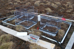 Experimental drying plots on the tundra
The carbon cycle is the means by which carbon is moved between the world's soils, oceans, atmosphere, and living organisms. Northern tundra ecosystems play a key role in the carbon cycle because the cold, moist, and frozen soils trap organic material and slow their decomposition. This very slowly decaying organic material has caused carbon to build up in the Arctic during the past thousands of years. Historically, the tundra has stored large amounts of carbon. Now warming in the Arctic is slowly causing the permafrost to thaw and the tundra to become warmer and dryer. As the earth warms and permafrost thaws, this previously frozen carbon is released as carbon dioxide and goes into the atmosphere, turning the tundra into a source of carbon, rather than a sink. Because carbon dioxide is a greenhouse gas, this additional carbon dioxide creates a positive feedback that leads to even further warming.
Little is known about respiration in the arctic winter. The team used five different methods in hopes of finding the best way to measure how much carbon is being released from northern ecosystems in the winter. Measuring winter respiration directly from experimentally warmed plots and understanding the drivers of wintertime tundra respiration will have the added benefit of being able to improve global arctic carbon models. More information about the project can be found here.
Reconstructing the Past Climate of Central Alaska
What Are They Doing?
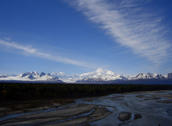 The Alaska Range near Denali National Park
The goal of the team's research was to develop a past climate and precipitation record of Central Alaska over the past 1000 years. In order to accomplish this task, the team extracted and analyzed a series of three ice cores from an ice divide between the North and South Peaks of Mount Hunter within Denali National Park and Preserve. They also continued ice depth and surface velocity surveying of major glaciers within Denali National Park and have plans for using this information to develop improved ice volume estimates and historical glaciological reconstructions of Central Alaska.
Research at this site is important as it completes the development of a spatial ice core array (a range of data) in the North Pacific that has been underway since the early 2000s, including climate records from the St. Elias Mountains, Coast Range, Brooks Range, and Wrangell Mountains. Mt. Hunter in central Alaska lies in a different precipitation and climate regime from these regions, and thus represents the missing piece in this array needed to evaluate spatial precipitation and atmospheric circulation changes on various timescales in this region of the Arctic. Considering the apparent teleconnections (climate phenomena related to each other and occurring large distances from one another) between the Arctic and Antarctic climate and meteorology, completing this array of ice cores may also provide information that is particularly useful for world glaciological and climate modeling purposes. More information about the project can be found at the University of Maine website.
Expedition Map
Arctic Wetland Dynamics in Finland
What Are They Doing?
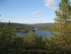 Lake Kevo in northern Finland
This project examined the poorly-understood interaction of climate change and microbial methane production in wetland soils in the Lapland region of Finland. The research team conducted field and lab experiments to determine the role of arctic wetlands in global carbon cycling. Similar experiments have also been completed by the research group in the Alaskan arctic, making this project part of an investigation into the potential global-scale response of arctic wetlands to impending climate changes.
The Arctic is experiencing the most dramatic warming due to climate change of all global systems. As arctic soils warm, the resulting rise in microbial activity increases emissions of carbon dioxide and methane, further accelerating global climate change. Because the vast majority of global carbon is stored in soils, and soil carbon is in flux with atmospheric carbon, soil microbes can either alter or exacerbate climate changes.
Methane is a powerful, carbon-based greenhouse gas, and wetlands are the largest natural source of methane to the atmosphere, but factors that influence net methane emissions from arctic wetland soils are not well understood. The Lapland region of northern Finland offered an ideal research environment because it has carbon-rich arctic wetlands different from those that exist in North America, offering the opportunity to comparatively study the controls on methane flux from arctic wetland ecosystems. More generally, carbon cycling research is critical for building accurate global climate models, which inform social and international climate change mitigation policies.
Arctic Ground Squirrel Studies
What Are They Doing?
 Arctic Ground Squirrel
In the Arctic, bright summers and dark winters are a fact of life and can lead humans to rely on clocks and routines to tell them when to eat or sleep, but how do animals function under these conditions? Circadian rhythms refer to the "internal body clock" that regulates the approximately 24-hour cycle of biological processes in animals and plants. Rhythms in body temperature, brain wave activity, hormone production, and other biological activities are linked to this 24-hour cycle. The Earth's light-dark cycle provides the strongest influence on circadian rhythms and is thought to be the primary driver for the emergence and evolution of internal clocks. In the Polar Regions, however, photoperiod exhibits extreme annual variation because of near 24 hour sunlight in the summer and 24 hour darkness in the winter. In the absence of a well-defined light-dark cycle, some arctic residents lose their daily organization of behavior and physiology, and it is thought that the molecular clockwork that drives circadian rhythms may be weak or absent in arctic vertebrates.
The research team has recently found that the arctic ground squirrel displays daily rhythms of body temperature throughout the arctic summer, in the absence of a light-dark cycle. The current study continues investigate the circadian rhythms in arctic ground squirrels during the continuous daylight present during the active summer season and continuous dark of the 6-8 months of hibernation spent sequestered in a burrow. The team wants to understand why arctic ground squirrels, unlike other arctic vertebrates, appear to maintain 24-hour rhythms during the active season. They hypothesize that the persistence of circadian rhythmicity allows ground squirrels to reduce energy expenditure by anticipating predictable changes in its immediate surroundings. They continue to test their hypothesis by experimentally phase-shifting free-living ground squirrels to be active at 'night' and estimating their subsequent rates of energy expenditure.
Biology of Antarctic Fishes 2013
What Are They Doing?
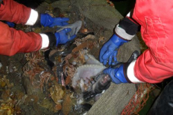 Trawling catch in Antarctica
Antarctic notothenioid fishes are uniquely adapted to life in the extreme conditions of the Southern Ocean. Waters surrounding Antarctica are unlike any other. The Southern Ocean is isolated from other oceans by the Antarctic Circumpolar Current, it is very cold with temperatures at or near -1.8 degrees Celsius, and the water is rich in oxygen. Notothenioids have evolved many physiological traits that enable them to survive in this remarkable environment. They lack a swim bladder and have antifreeze proteins that prevent their bodies from freezing. Members of one family of notothenioids, the Channichthyidae (icefishes), are unique among all vertebrates because they lack the circulating oxygen-binding protein, hemoglobin.
The loss of hemoglobin is considered a neutral mutation; one that neither enhances nor reduces fitness. However, the team hypothesizes that the loss of hemoglobin may be an advantage because hemoglobin promotes the formation of reactive oxygen species that damage macromolecules. Overall, the team's research was aimed at understanding the unique physiological and biochemical traits that have arisen in fishes during their evolution in the chronically cold waters of the Southern Ocean.
Arctic Sunlight and Microbial Interactions
What Are They Doing?
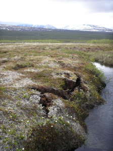 Thawing permafrost
Tremendous stores of organic carbon frozen in permafrost soils have the potential to greatly increase the amount of carbon in the atmosphere. Permafrost soils may thaw sporadically, and melting ground ice can cause land-surface subsidence called "thermokarst failures". These failures change the rate and amount of carbon released with the unanticipated outcome being that soil carbon can be mixed-up from a depth and exposed to sunlight as the land surface fails. Sunlight can photo-degrade organic carbon and alter the carbon's ability to support bacterial respiration to produce carbon dioxide. Whether UV exposure will enhance or retard the conversion of newly exposed carbon to carbon dioxide is currently unknown—in this study team is providing the first evidence that this alteration will be amplified by photochemical processes and their effects on microbes.
The research team is trying to understanding exactly how sunlight and bacteria degrade dissolved organic matter by determining how fast these processes convert newly released dissolved organic matter to carbon dioxide, compared to dissolved organic matter already in surface waters. The team will accomplish their research objectives with a series of laboratory experiments to determine rates of photodegradation and microbial processing of dissolved organic matter from different sources, and a series of landscape comparisons and sampling transects to characterize dissolved organic matter degradation in small basins and large rivers extending from the headwaters to the Arctic Ocean. Ultimately, this research will attempt to answer questions such as whether carbon export from tundra to oceans will rise or fall and how reactive the exported carbon will be. The team hopes to be able to measure the ultimate impact of impending disturbances, including climate change, on the net carbon balance of the Arctic and its interaction with the global carbon cycle.
Predatory Spiders in the Arctic Food Web 2013
What Are They Doing?
 Female wolf spider in Alaska
The Arctic is warming faster than any other biome on the planet, which makes it critically important to understand the influence of warming on ecosystem processes in this region. While arctic species are all well adapted to living in extreme environments, it is unclear how different species will respond to the environmental shifts that accompany climate change (e.g. longer growing seasons and warmer temperatures). Stronger responses by some species within a community could lead to changes in the structure of the food web and its role in arctic ecosystems. In the Alaskan Arctic, wolf spiders are the largest and most abundant invertebrate predators. A shift in their ecological role could therefore have an important impact on the entire food web.
This project explored the role of wolf spiders within arctic communities and specifically, whether climate change is stimulating changes in these predators that could influence the structure and function of food webs. In particular, arctic warming could increase decomposition of the large amounts of carbon stored in permafrost soils. Increased decomposition would result in higher levels of atmospheric carbon dioxide and methane, which are heat-trapping greenhouse gases. Potential shifts in spider feeding ecology as a result of climate change could therefore have important and far-reaching consequences for arctic plant community dynamics and ecosystem processes. This research examined the extent to which arctic wolf spiders influence the structure and function of food webs and measured whether their impact on the community is changing with warming.
Joint Science Education Project 2013
What Are They Doing?
The expedition members visited several research sites in Greenland as part of an initiative to foster enhanced international scientific cooperation between the countries of United States, Denmark, and Greenland. The expedition members spent several days learning about the research conducted in Greenland, the logistics involved in supporting the research, and gain first-hand experience conducting experiments and developing inquiry-based educational activities.
In 2013, the work built on past expeditions and was supported by the National Science Foundation. The project was developed through cooperation with the U.S.-Denmark-Greenland Joint Committee, which was established in 2004 to broaden and deepen cooperation among the United States, the Kingdom of Denmark, and Greenland.
The program had two components
Kangerlussuaq Science Field School: 28 June - 10 July 2013
Science Education Week: 11- 18 July 2013
Historical Ecology for Risk Management
What Are They Doing?
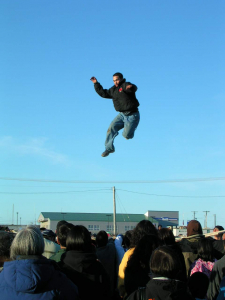 Traditional blanket toss in Barrow, Alaska
Applied Research in Environmental Sciences Nonprofit, Inc., ARIES, the Barrow Arctic Science Consortium, BASC, and the North Slope Borough of Risk Management are collaborating to plan, develop and implement a historical ecology model for the North Slope Coastal Region of Alaska.
Historical ecology is an applied research program that focuses on interactions of people and their environments. Research applications involve studying and understanding this relationship in both time and space to gain a full picture of all of its accumulated effects. The research program can be applied to understanding changes among community landscapes that can assist strategies for the future. For this proposal the emphases align with the ARIES mission that combines research, education, and community outreach.
The emphases are 1) a bibliographic database of relevant historical resources, 2) an examination of the shoreline to provide a time-series baseline 3) simulation models to demonstrate socio-natural cycles of change for the North Slope shoreline, 4) the historical ecology study of the shoreline, interactive mapping and database available as a web based resource to assist academia, industry, regional government and local communities for socio-cultural and management purposes, 5) an integrated team who can work with interested researchers, industry planners and Risk Management of the North Slope Borough to extract data and provide simulation models that apply to current studies of the region and 6) provide a variety of eco-heritage opportunities that include community participation in research, educational products, age level appropriate activities and outreaches for community service learning.
This includes natural and social science research and use of eco-heritage data for disaster preparedness among the "Next Generation", that is, middle and high school students. This aligns with the Cumulative Risk Integrated Operability Project (CRIOS) with DHS CREATE funds, since 2008, to reduce risks across emergency management jurisdictions of tribally inclusive geographic areas (TIGA). Here is the project website.
Expedition Map
Chukchi Sea Ecosystem Study
What Are They Doing?
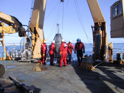 Lowering sampling instruments into the Chukchi Sea
This project attempted to understand the role of carbon resources to the food webs of the Chukchi Sea, off the northwest coast of Alaska. The northern Chukchi Shelf receives large inputs of organic matter transported from the highly productive shelf regions of the North Pacific and from existing sources of primary production, including ice algae, sediment microalgae and phytoplankton. These contributions of highly changing organic carbon, together with potential benthic (from the bottom of the sea) sources of nutrients, likely contribute to the enormous secondary production (production of living material by organisms) of this region. In particular, the relatively shallow depths (40-55 m) and high bottom flow have created "hotspots" of biological productivity found in the vicinity of the Hanna Shoal region of the Chukchi Sea.
The research team included scientists from seven institutions and two federal agencies. The work took place over dozens of existing sampling stations and involved collaboration with other science studies in the region sponsored by federal, state, or industry interests. Due to the biological significance of this region and its importance for oil and gas exploration and development, the group examined the range of biological, chemical, and physical properties that define this ecosystem.
The group focused their efforts on the Hanna Shoal region, with the addition of a pelagic (from the open ocean) component to address standing stocks of phytoplankton and zooplankton, and a physical oceanographic study that addressed water mass movements through direct measurement of circulation, density, and ice conditions.
Drumlin Formation in Iceland
What Are They Doing?
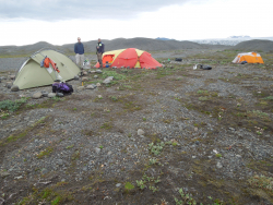 Field camp on the glacier foreland
This project sought to understand the formation of drumlins, some of the most mysterious and poorly understood of glacial landforms. Drumlins are elongated, aligned hills that form hidden from view beneath glaciers. The first modern drumlin field has recently been exposed by the retreat of Múlajökul. Previously this kind of landform could be studied only by focusing on drumlin fields that formed long ago in the Pleistocene, so this study provided a unique opportunity to understand drumlin formation better.
The research team collected intact till (rocks and finely ground material picked up by a glacier, and deposited as sediment along its path) samples from the drumlins and the surrounding area. The samples were taken back to Iowa State University and the University of Wisconsin Milwaukee and subjected to geotechnical tests and magnetic fabric analyses. This testing determined the former distribution of stresses on the till and patterns of subglacial till deformation that were likely central to the formation of the drumlins. In addition to helping determine the internal structure of drumlins and how drumlins form, this research will shed light on the distribution of basal drag beneath glaciers—an important and poorly understood factor in their dynamics.
Northern Alaska Coastal Ecosystems
What Are They Doing?
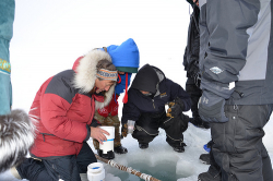 Water sampling with students from Kaktovik, Alaska
Coastal ecosystems of the Arctic receive extraordinarily large quantities of terrestrial organic matter through river discharge and shoreline erosion. The fate of this organic matter is of both local and global interest as it relates to biological production in the coastal ocean as well as the global biogeochemical cycle. Terrestrial organic matter has the potential to provide an important source of carbon and energy to support and maintain organisms and food webs in coastal waters during much of the year. The goal of this research was to determine how seasonally distinct terrestrial inputs of water and organic matter influence microbial and animal communities in coastal waters of the Alaskan Beaufort Sea.
Research sites ranged from lagoons to open coastal systems and each site was used to examine linkages between biological communities and organic matter inputs from land. Measurements of water and sediment chemistry, and benthic and water column community characteristics were used to evaluate the importance of terrestrial inputs under different hydrologic/hydrographic conditions.
Understanding the fate of terrestrial carbon in arctic coastal waters is especially important now as the arctic system enters a period of rapid climatic change. Changes in terrestrial organic matter export could influence the productivity and roles of organisms in arctic coastal waters. Such shifts have consequences for local human populations that fish and hunt for subsistence and for the broad scientific community interested in land-sea coupling.
In addition to their research, the team continued their successful K-12 outreach program entitled "Climate Change in the Arctic: An Interactive Program Linking Scientists with K-12 Students". This included the continuation of a summer field science program for native Kaktovik K-12 students. The Village Council has continued to express keen enthusiasm to involve school children in hands-on science activities that support learning of key science concepts.
In addition, PolarTREC teacher Jill Smith learned about the cultural importance of the annual bowhead whale hunt that began while she was in residence at Kaktovik. She had the opportunity to share this information through real-time video connections with her students in her home classrooms in Texas, enabling students from Texas to have direct dialogues with students in rural Alaska.
Expedition Map
Tectonic History of the Transantarctic Mountains 2013
What Are They Doing?
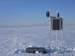 Seismic station on the ice
Antarctica plays a central role in global tectonic evolution. Competing theories have been put forward to explain the formation of the Transantarctic Mountains (TAMs) and the Wilkes Subglacial Basin (WSB), primarily due to a lack of information on the crustal thickness and seismic velocity of these areas. The research team has attempted to resolve how the TAMs and WSB originated and how their formation relates to Antarctica's geologic history. Since most of Antarctica is covered by large ice sheets, direct geologic observations could not be made; therefore, "remote sensing" methods like seismology had to be used to determine details about the earth structure.
The goal of this project, funded by the National Science Foundation, was to broaden our knowledge of geology in this region with a new seismic array; the Transantarctic Mountains Northern Network (TAMNNET), a 15-station array across the northern TAMs and the WSB that helped fill a major gap in seismic coverage. Data from TAMNNET was be combined with that from previous and ongoing seismic initiatives and was analyzed to generate an image of the seismic structure beneath the TAMs and the WSB.
While in the field, the team spent most of their time servicing the seismic stations that compose the new TAMNNET array. This included loading equipment onto small airplanes, flying to remote field locations, uncovering the deployed equipment, and checking for any maintenance issues. The first batch of data from the network was also retrieved during this time.
Expedition Map
Soil Ecology in Antarctic Dry Valleys
What Are They Doing?
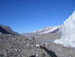 Dry soils of the McMurdo Dry Valleys, Antarctica
It's hard to imagine that anything could live in the cold, dry soils of Antarctica. Early investigations of the soil bacterial communities of the McMurdo Dry Valley found only a handful of bacteria, leading to the conclusion that these soils were essentially sterile. The idea that microorganisms can grow at all in the very dry soils of the McMurdo Dry Valleys seems astounding but the recent use of advanced molecular biology techniques to investigate soil biodiversity has revealed a surprising bacterial richness in the area.
The goal of this project was to identify active members of the McMurdo Dry Valley soil microbial community and determine their ecological role. Little is known about bacterial populations in the Dry Valley soils, but until it is understood which populations are active and what they do, it is impossible to understand the ecological role that bacteria play in ecosystem function.
Ice Cube Neutrino Observatory 2013
What Are They Doing?
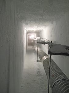 Tunnel under the Ice Cube Neutrino Observatory
How do you find something that isn't directly visible? That's the challenge faced by the team that developed the IceCube neutrino detector under the ice at the South Pole. Just as X-rays allow us to see bone fractures and MRIs help doctors find damage to soft tissue, neutrinos will reveal new information about the Universe that can't be seen directly. The in-ice particle detector at the South Pole records the interactions of neutrinos which are nearly massless sub-atomic messenger particles. Neutrinos are incredibly common (about 100 trillion pass through your body as you read this) subatomic particles that have no electric charge and almost no mass. They are created by radioactive decay and nuclear reactions, such as those in the Sun and other stars. Neutrinos rarely react with other particles; in fact, most of them pass through objects (like the earth) without any interaction. This makes them ideal for carrying information from distant parts of the universe, but it also makes them very hard to detect.
All neutrino detectors rely on observing the extremely rare instances when a neutrino does interact with a proton or neutron. This transforms the neutrino into a charged particle of the same type as the neutrino flavor (electron, muon, or tau). Muons are charged particles that can travel for 5-10 miles (8-16 kilometres) through matter depending on their energy, and generate detectable light in translucent media.
IceCube is made up of thousands of sensitive light detectors embedded in a cubic kilometre of ice between 1450 m and 2450 m below surface. The sensors are deployed on strings in the ice holes that were made using a hot water drill. IceCube detects about 300,000 neutrinos a year, and has a projected life time of two decades. The data collected will be used to make a "neutrino map" of the universe and to learn more about astronomical phenomena, like gamma ray bursts, black holes, exploding stars, and other aspects of nuclear and particle physics. However, the true potential of IceCube is discovery; the opening of each new astronomical window leads to unexpected discoveries.

