A Typical Day
Now that I have been here for several days I can provide an accurate description of what a typical flight day is like.
5:30 am - The flight crew mechanics open up the plane and begin preparing it for takeoff. If the temperature is below 0ºF they will have to deploy the diesel powered engine heaters to warm the P3's four engines prior to start up. They do a walk-around working through a standardized checklist, paying close attention to wear parts (tires, engines, etc.). This will take the entire crew (pilot, co-pilot, flight engineer, mechanic/safety officer, ground crew) until nearly 8 am.
6:00 am - By now everyone who is going on the flight will be awake. My goal is to get dressed, eat breakfast, wash my dishes, make and pack a lunch, and then pack my backpack for the day, all by 7 am. Things I take with me include my laptop, cameras, notebook, and warm clothes. I also bring Flames (dragon) and Dusty (muskox), my kids' two stuffed animals that were specially chosen to join me in Greenland. The warm clothes are necessary as the temperature inside the plane can vary quite a bit. I've worn just a t-shirt at times while others I've needed the whole wardrobe: fleece, down coat, and hat.
6:30 am - Over at the Metereological Office our navigator/amateur meteorologist (Jon Sonntag) and team leader (Michael Studinger) go over the latest weather information and finalize our flight plan. There are about 72 routes to fly in Greenland but only time for 50 or so. They have to prioritize which routes are most important, determine which routes have good weather, and keep track which routes remain as possibilities.
7:00 am - I start the walk over to the airport. It's about 7 minutes one way to the plane. I can hear the APU (auxiliary power unit) running as soon as I step outside. My commute takes me past the colorful residential buildings of Kanger. In much of Greenland the locals have taken to adding color to their otherwise grey scale surroundings by painting their buildings brilliant pastel colors.
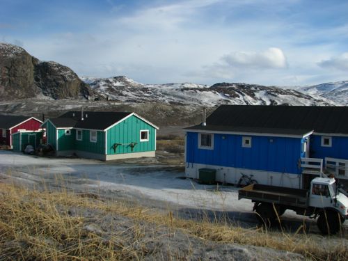 The colorful palette of Kangerlussuaq.
7:30 am - Everyone who is going on the day's flight must be on board by this time even though the plane will not leave for another hour. I hang up my backpack with a carabiner and prepare my cameras. I settle in to my favorite seat which is in the very back next to Jim Yungel, a veteran ATM (airborne topographic mapping) scientist. He runs one of the two lasers that determine the height of the surface of the ice and seems to be an endless database of knowledge regarding all things related to OIB. Jim has been doing this longer than anyone else on the plane. Jon, the navigator, posts the day's flight plan on a wall inside the plane. He has three colored maps that depict the route for us. Inside, a plane-wide internet allows each scientist to follow the plane on a map, access the nose camera, and view a nadir camera (pointed straight down), among other things.
8:00 am - The doors close around this time and the ground crew pulls the stairs away. The flight crew starts the engines and allow them to get up to temperature before taxiing. Everyone buckles in at this point.
8:30 am - By this time we have taken off. The taxiway is short and there is never any air traffic to deal with. Our takeoffs are to the west, down-fjord.
8:30 am - 4:30 pm: Flying. We don't land during this time and there are only about 4 or 5 airports in Greenland that we could land at if we needed an emergency landing strip. People nap on top of the padded engine covers on a rotating basis. The scientists monitor their instruments during the flight but most need little attention. When conditions change - clouds show up or we notably alter our altitude - then they'll need to make adjustments. Before landing we often fly over the ramp at the Kanger airport as a means to calibrate the the ATM and the DMS (digital mapping system - basically our digital cameras) devices.
4:30 - 5:00 pm: Hard drives are removed from the plane and packed in waterproof cases. The engines run another 4 minutes to cool them down before they are shut off entirely. The navigator and team leader drive over to the meteorology office for another weather briefing. And the ground crew spends about 2 hours maintaining the plane and preparing it for the next day. I try to make it to the one grocery store in town to purchase food but I have only made it once in the week that I've been here. They close at 5 pm. If I can't get groceries then I have to survive on the equivalent of convenience store rations. Not ideal.
6:00 pm: Everyone meets in the upstairs lounge at the KISS building (our dorm) for a science meeting. Michael Studinger (team leader) reviews the day's progress, Jon (the navigator/weatherman) goes over the tomorrow's forecast and possible routes are discussed. We develop the flight manifest for the next day - who's flying, who's not. After all questions are answered the meeting is adjourned.
Following the meetings nearly everyone seeks some form of dinner and about 90% of those seeking dinner go to the one restaurant in town (the Polar Bear), two doors down from the KISS building. The Polar Bear serves pizza (passable), Thai food (quite bad), sandwiches (survival rations), and a few other assorted items. Nothing they serve rises to the category of "good food," but with good company you can be distracted enough to swallow it down.
Summit Station
Along today's route were three passes in the vicinity of Summit Station, the permanently staffed research facility located at the highest point in the country, about 10,500' in altitude. In 1993 workers there completed drilling through more than 3 km of ice, finally reaching bedrock.
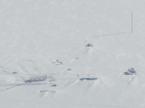 Summit Station as viewed from our plane. The "big house" is in the lower right hand corner. It's the main common area which includes offices and a galley.
Today the station has a staff of around 60 during the summer and about 5 during the winter. The facility is an important base for all kinds of polar science: climate studies, albedo measurements, subglacial lakes, arctic clouds, pollution, etc.
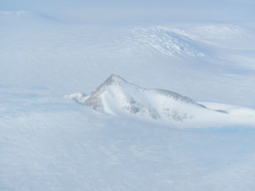 Nunataks are peaks that stick out of the ice sheet. Then tend to more pointy than other mountains because they escape the glacier's erosional powers.
Going to the Dogs
Walk half a mile west from the KISS building and you drop down on to the mudflats at the very head of the Kangerlussuaq Fjord. Here, the glacier-smoothed bedrock melts into miles of mudflats comprised of glacier-ground rock. A few more miles west and the mudflats give way to salt water - the fjord itself. Continuing westward, follow the fjord for 100 miles or so and you are out in the open ocean - finally.
But down on the mudflats on the west end of town, not far from the runway, is Kanger's sled dog lot. Unlike Alaska where each owner has their own kennel, here all sled dogs are kept in a fenced lot on the outskirts of town.
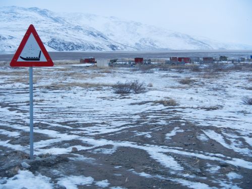 You don't see these caution signs everywhere. Snowmachines are not nearly as prevalent here as they are in Alaskan villages. And so dog sled teams are used for work purposes more often than not. Leading out of Kanger are well-worn dog sled trails heading out the ice covered fjord to the west and into the hills to the east.
After dinner I fought a cold, stiff wind and made my way down there to investigate. The dogs are officially Greenlandic huskies, a heavier, furrier breed than most Alaskans use. They are raised from the beginning as work dogs and will be treated as such their entire lives (i.e. no petting). I saw several teams chained up in various pens as well as a few strung out as if ready to run. For whatever reasons the puppies were allowed to run loose.
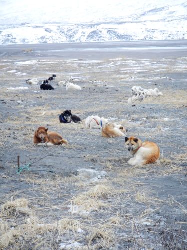 These dogs live chained up out in the open waiting for the next trip.
The wooden sleds are heavy enough to hold a pile of dead seals, a muskox, or a few reindeer. They are lashed together not with nails or screws, but with twine so as to maintain their flexibility. The dogs are attached in a fan-like formation in front of the sled, again different from the linear arrangement used in Alaska. All of the dogs looked looked well fed and none of them howled while I was there.
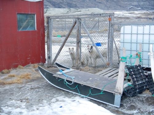 A typical Greenlandic sled with a couple of pullers-in-training.
Question of the day: Our average air speed is 250 knots or nearly 300 mph. If we fly for 8 hours at this speed how far have we gone?
Harder question: The scientists collect about 2.5 Terabytes of data during an 8 hour flight. How many bytes of data per second do they collect on average?


Comments