The Nussuaq Peninsula
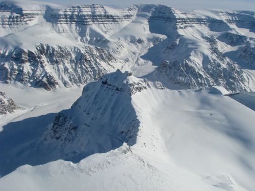
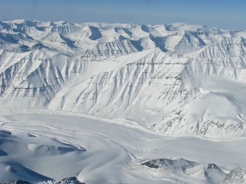
Today we headed north and a bit west of Kanger to the Nussuaq Peninsula, a place OIB has not ever visited. The reason for going here is that there are small ice caps in the area and small pieces of ice respond faster to a warmer climate than do larger ones. The scientists wanted to get some data on this area to establish a baseline for future measurements. The mountains covering the peninsula extend to about 6000' above sea level and are comprised of sedimentary rock. (Question: Look at the pictures - how can you tell they are sedimentary in nature?)
 Isolated from the rest of the Greenland Ice Cap, separate, smaller regions of ice have seen increasing interest from scientists in recent years due to their disproportionate loss of ice.
 The sedimentary rocks in this area form spectacular valleys and ridges.
 While there is relatively little ice in this region of Greenland the scientists consider it an important bell-weather: small ice caps like these tend to react more dramatically to a changing climate than do their larger counterparts. The cliffs in the foreground drop about 3000' vertically down to the glacier below.
I have received a few questions about the engine covers that various crew members nap on during the flight. Here are a couple of photos to give you the idea.
 The project leader, Michael Studinger, relaxes on the preferred napping spot.
 If the first napping spot is taken, go for option 2.
There are four engines and hence four engine covers. They are made of cordura nylon with about 3/4" insulation all around. When stuffed into their storage sacks they nicely approximate a bean bag. Many instruments have two people running them and even so, often need little management during a flight. As such, naps happen. The steady drone of the engines helps to lull one into a peaceful slumber. But when conditions change - our altitude, it gets cloudy, etc. - some of the instruments need adjusting. And when turbulence hits our flight crew quickly ushers us into our seats with belts buckled.
More about our Airplane - the P3 Orion
Lockheed began producing the P3 in the early 1960's as an anti-submarine aircraft. Equipped with what looks like a stinger sticking out the rear of the plane, P3's used this magnetic anomaly detector (MAD) to locate submarines underwater. (AP Physics students - the presence of a large, ferrous object in the water subtly changes the ambient magnetic field from the earth, both in intensity and direction. The detectors were so sensitive that they needed to be placed as far away as possible from any other source of magnetic fields. Hence they stuck out the back.) Once a submarine was detected, the plane could then drop depth charges from its bomb bay to destroy the target. The NASA P3 that we use no longer has a MAD installed in the stinger and the bomb bay has been refitted to house scientific equipment rather than ordnance. After a useful life in military service, our P3 was mothballed for some years in the California desert before reincarnated as an airborne science platform. P3's have an extraordinary pedigree for extended duration flights in difficult conditions. As an anti-submarine plane they would fly at 200 feet over salt water for 12 hours at a time with no ill effects after long term deployments. It is one of few aircraft that the military still uses more than 50 years after development (though they are slowly being phased out in favor of the P8). The NASA P3 is going to get new wings next year which means it could technically keep going for a few more decades. Amazing!
Here's a video walk through of our plane. I hope this gives you a sense of the size of the plane and where people sit, how the equipment is configured, etc.
http://youtu.be/gC-XWzR7MRQ
Finally, here's a couple of flyby videos I've been meaning to post for awhile now. It's taken awhile to render these and reduce the format size, etc. This first one is from northwestern Greenland.
http://youtu.be/HJYGSw1cjk0
This second video comes from the exact opposite location on the island as compared to the first. This is a flyover of the Heimdal Glacier in southeast Greenland.
http://youtu.be/anaMoeQP1CY
We will be doing the PolarConnect event live on Friday, 4/18 at 12 pm Alaska Daylight time. I'll include instructions for setting up your computer for the event in an upcoming journal. Stay tuned!!!


Comments