Early morning – got up at 5AM and headed to the airport to catch Frontier Airlines for Nome. After two hours and a few winks, I’m now here in Nome. I was scheduled to catch a flight from Nome to Gambell at 1PM but that has already been delayed until 3PM. This brings back memories of earlier years when I used to fly out to remote communities – such as Gambell, Savoonga, Wales, and Diomede – when I worked for the U.S. Fish and Wildlife Service. Bad weather, namely fog, hinders travel and can keep communities such as Gambell hidden for days on end. In the past, I spent many days in Nome trying to get out to these communities. I hope that won’t be the case for me today – so far I see partly cloudy skies.
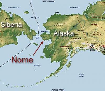
You can get a better sense of where I am and where I’m going with this map of Siberia and Alaska. The arrow points to Nome and Gambell is located on St. Lawrence Island – the large Island just southwest from Nome.
 Map of Alaska showing location of Nome.
Map of Alaska showing location of Nome.
The USCGC Healy is just off the coast of St. Lawrence Island and will be in this general vicinity for several weeks. When I get on the ship, I’ll be sure to post a cruise track. In the meantime, I’m off to seek out some coffee and check out Nome!
