What a way to spend New Year's Day! Today, Maurice and I hiked to the summit of Mt. Hope. (We are currently camped on the northeast ridge of the mountain.) John and Perry had set off around 9 a.m. to collect samples along the east ridge on their way to the summit. Maurice and I left camp at about 10 a.m. for our hike. The top can be accessed easily - it is simply a scramble over rocks and snow. The easiest way to get there is by donning crampons, grabbing an ice ax and heading up the snow/ice fields. There is a short bit near the summit where you have to take off the crampons and scramble up some scree slopes and over/around boulders.
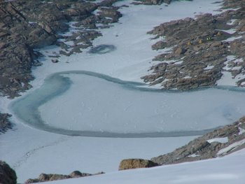
 This is a view of our camp down on the northeast ridge of Mt. Hope. Just to the upper right of the frozen glacial lake you can see our three Scott tents and the endurance cook tent.
Our camp is on a bit of rock outcrop surrounded by snow, so we began our trip with the crampons. We headed north out of camp and skirted the large glacial lake just over the hill from camp. From there, it was up and up and up the snow/ice field. At the saddle below the summit, we stopped for lunch and to remove our crampons. Then we hiked the remaining 500 feet of elevation gain to the top.
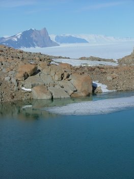
 The view we had while eating lunch on our hike to Mt. Hope's summit. The pointed peak in the upper left is Mt. Kyffin where we were camped for Christmas. The long white expanse at the base of the far mountains is the Beardmore Glacier.
Being on the top of Mt. Hope was amazing! I nearly cried when I got to the summit and saw the view - but stopped short when I realized that the tears would freeze on my face. From the summit you can see the Transantarctic Mountain chain stretching away from you to the right and left. To the south, you can see the Beardmore Glacier extending toward the polar plateau, and to the north, the Ross Ice Shelf stretches all the way to the horizon. From our vantage point, we could see the other two mountains where we've camped: Cloudmaker Peak to the south and right of the Beardmore Glacier, and Mt. Kyffin south and to the left of the Beardmore Glacier. To stand where intrepid explorers, such as Shackleton, have stood and to see the view that held such promise was awe inspiring.
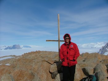
 Here I am on the summit of Mt. Hope. The cross is an aerial survey marker placed at the United States Geological Survey (U.S.G.S.) benchmark location. Almost directly behind me (looking south) is the Beardmore Glacier. Mt. Kyffin and other mountains in the eastern Transantarctic Mountain range are to the left and the western Transantarctic Mountains are to the right.
When Shackleton was sailing along the edge of the Ross Ice Shelf, looking for a route to the South Pole in 1907, they finally found a place where they could anchor and climb onto the continent. They climbed Mt. Hope for a look southward and from the summit they saw the Beardmore Glacier for the first time. The Ross Ice Shelf just north of Mt. Hope is very highly crevassed, but just to the west, they saw The Gateway, a small opening in the mountains that would allow them to by-pass the end of Mt. Hope and cut across to the Beardmore Glacier. >From Mt. Hope, the Beardmore Glacier looked very smooth and they could see it disappear toward the polar plateau. It received its name because it gave Shackleton hope that they could reach their goal. On this trip, Shackleton and his men were able to come within about 75 miles of the South Pole before they were forced to turn around due to lack of food. This is the same route that Scott took on his ill-fated journey to the South Pole.
 Looking from the summit of Mt. Hope down toward the Gateway. This is a narrow section of glacier that connects the Ross Ice Shelf and the Beardmore Glacier. Shackleton and Scott used this route on their bids for the South Pole. It is the narrow expanse of snow that disappears between the two mountains in the center of the photo.
.
John and Perry were coming up the other ridge looking for samples and we were supposed to meet at the summit for a group photo. Maurice and I got to the summit around 2 p.m. and spent about 45 minutes on top. It was quite windy and cold, so we decided not to wait any longer, and headed down. About 700 ft. below the summit we saw John and Perry and they said they still had samples to collect and wouldn't be up there for a couple of hours yet. Maurice went over to collect some of their samples and said he'd catch up to me. I continued to truck on down the mountain across the snow field. I was in the zone and enjoying the scenery, stopping to take pictures often, when all of a sudden, I realized that I was running out of land! The crevasses in the Ross Ice Shelf were right there at eye level. So, the hike ended up being much longer than planned, since I had to turn around and go back about 600-700 feet up the hill I'd just come down. I looked back, and there was Maurice, he was just following me along, enjoying the scenery as well. He hadn't noticed that we'd missed our turn either.
 Looking down on the Ross Ice Shelf from the summit of Mt. Hope. These are enormous crevasses! Some of them are large enough to easily swallow a semi-tractor trailer. You can see why Shackleton was relieved to have found a route that would allow them to avoid these.
Even though we had more elevation gain than we'd planned when setting out on the hike, I didn't feel so tired. It must be something about being in such a beautiful, remote, and historic place that makes every little effort seem so worth while.
 Here I am making my way down from Mt. Hope's summit. I was enjoying myself so much that I missed the turn toward camp and got to do this for about an hour longer than expected!
