Yesterday you were introduced to the climate of Svalbard, and today the lesson will switch to the geologic history of Svalbard. Before we begin, I suggest brushing up on the topic of deep time because we will be talking about durations of time quite a bit longer than an imaginable life time. Go to the University of California Paleontology Museum tutorial at: http://www.ucmp.berkeley.edu/education/explorations/tours/geotime/gtpage1.html or the tutorial on the Athro website at http://www.athro.com/geo/hgfr1.html for quick lessons in geologic time.We'll start with a geographic orientation. The Svalbard archipelago is part of a vast continental shelf on all sides except to the west where the continental shelf drops off to a trough between Svalbard and Greenland. The bodies of water surrounding Svalbard include the Barents Sea to the south and east, Arctic Ocean to the North and the Greenland Sea to the west.
 Kapp Linne is on the west at the opening of the big fjord. Image courtesy of Norwegian Polar Institute
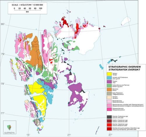
Formed during the Precambrian to Silurian time, the basement rocks are the oldest (some grains dating back 3.2 billion years) on Svalbard and consist of igneous and metamorphic rock and little evidence of 3 periods of mountain building. Found within the basement rock are "tillites," remains from glaciation that occurred during the Precambrian over 600 million years ago possibly from a time when Svalbard was closer to the South Pole. We will probably find some of these rocks while in the field here at Kapp Linne. The last period of mountain building called the Caledonian Orogeny (mountain building period) occurred about 400 million years ago, and these old rocks make up the formation known as the Hecla Hoek forming the mountains on the west side the Linne Valley - our field site. During the Caledonian Orogeny, Svalbard was caught in the big squeeze that formed mountain chains in Europe, Scandinavia, North America, and Greenland.
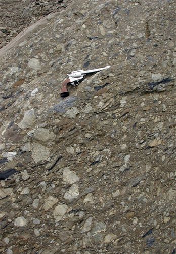 Picture courtesy of Jon Landvik, 2003
Also during this time period, Svalbard migrated closer to the equator where it remained for the balance of the Paleozoic era. Can you think of the evidence a geologist might find to support this? If you are thinking fossils, you are correct. Can you think of the types of fossils they would find? (hint: think about the climate around the equator) This was a time when the marine (carbonate) rocks and the terrestrial (clastic) rocks accumulated on land. The result of this time period was the formation of coal seams which are still mined today.
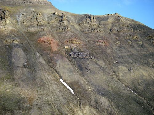 A better shot of the mining operation
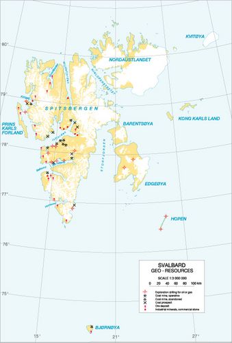 Note the geologic resources of Svalbard. Map courtesy of the Norwegian Polar Institute
As (geologic) time progressed and the "dance of the plates" plate tectonics brought together all the land masses to created Pangaea, Svalbard was migrating further and further north. Describe how the climate would have changed? How would the fossils look any different from the fossils from a previous time? During this time the Barents shelf formed and Svalbard continued to accumulate shallow marine sediments. Later in the Mesozoic period, Pangaea began to rift and the Atlantic Ocean formed and Europe moved further north. Dinosaurs roamed Svalbard during the Cretaceous as it landmass continued its northward migration. By the time the Tertiary period began, Svalbard was at the same latitude as present day Norway, but the global climate all over the Earth was warm. Can you figure out what types of biomes existed on Svalbard at that time? The remnants of this time period are the coal seams that are still mined today with the Carboniferous coal seams. If you look closely at some of the mountainsides you will see the mining equipment. During the Tertiary, uplift, erosion, and rifting (note the location of Svalbard related to the position of Iceland and the mid-Atlantic Ridge) began shaping Svalbard into the archipelago it is today.
If you look closely at the air photo of the Linne Valley you see the older Hecla Hoek formation on the right (west) and the younger Carboniferous limestone on the left (east). Why do you think we need to know about the geology of this valley if we are studying the glaciers? Also, look closely at the bedrock geology map for the details of the rock formations in our study area. (be careful - the air photo is looking to the south, whereas the diagram is looking north).
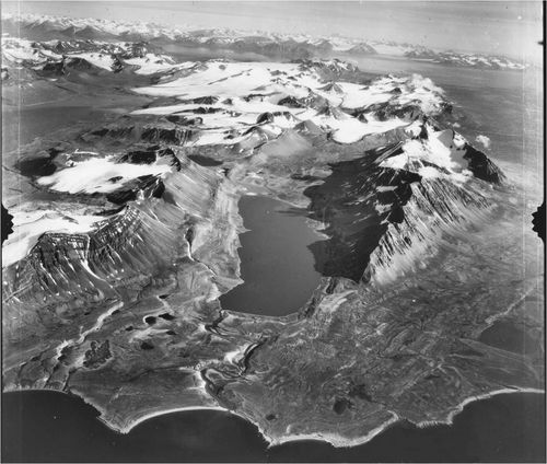 Our study area looking from north to south. Photo courtesy of Norwegian Polar Institute
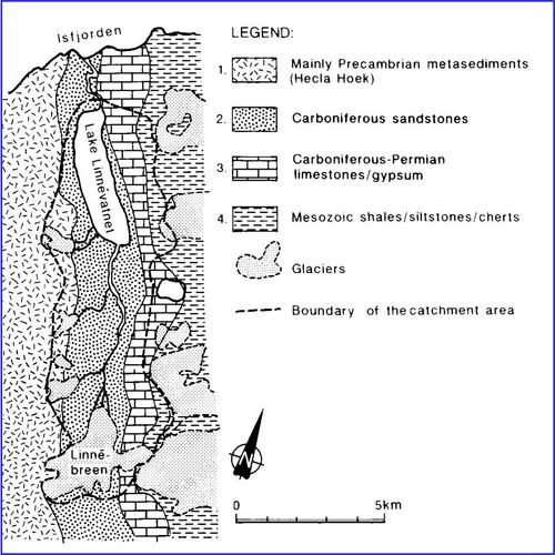 Link the formations to the periods of time they were created. Map courtesy of Svedson, et al 1989
Now that we the early geology outlined, we need to discuss the recent geology. One of the next journal entries will be devoted to the reason why we are here - the Quaternary period and more specifically the Holocene and the Little Ice Age.
For additional information on the geology of Svalbard visit: Outline of the Physical Geography and Geology of Svalbard http://www3.hi.is/~oi/svalbard_geology.htm Geo NP Net http://geonet.npolar.no/items-general/frame.html
Reference: Steve Roof powerpoint presentation presented during a lecture at UNIS on July 15, 2008.

