Speed 4.1 knots (kts) Course 289° Location 75.78° N, 155.59° W, Canada Basin near Northwind Ridge Depth 3483 meters
SPECIAL FEATURE DISCUSSION:
(see 8/17/10 journal for the questions.)
As you can see on the information plaque, each lifeboat has a capacity of 25 passengers. With 8 lifeboats on the ship that means there is room for 200 people aboard the lifeboats. We currently have 112 people on board (Coast Guard crew, science team, and visitors) so there would be plenty of room for everybody in the worst case scenario of loading lifeboats.
Barrow, Alaska is the northernmost city in the U.S. Nearby Point Barrow, at the end of a spit of land a few miles north of Barrow, is the northernmost point of land in the United States.
TODAY'S JOURNAL:
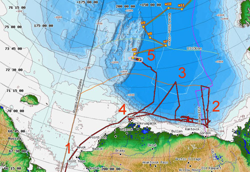
As we continue to cruise deeper into the Arctic I thought I'd recap our travels so far. On August 2 we departed Dutch Harbor in Alaska's Aleutian Islands. We sailed north through the Bering Sea, passing through the Bering Strait into the Chukchi Sea on August 5. This was the westernmost portion of our cruise, at just over 168° W longitude. Near Point Hope (#1 on the map below) we began to veer to the east, roughly following the Alaskan coastline about 20-30 nautical miles off shore. Once north of Alaska we continued eastward, traversing above the Beaufort Slope (the steep sea floor transition from shallow to deep waters) along the southern Beaufort Sea. This continued until we were north of the US / Canada border (#2 on the map below.) From there we mapped and sampled along a triangular route that took us into our first ice, getting as far north as about 75.25° N latitude.
We then returned south to the Beaufort Slope and headed back west before making another triangular mapping leg north into the Beaufort Sea. This area was mostly ice-free and took us north to nearly 74° latitude at around 145° W longitude (#3 on the map below.) Next we proceeded to the vicinity of Barrow to pick up a crew member and fuel filters for the Canadian Coast Guard Cutter Louis S. St. Laurent (#4 on the map) before heading back north into the Beaufort Sea. We met up with the Louis just before the ice edge to take our station about 1 nautical mile ahead of them, clearing a path so they could tow their seismic streamer in clear water. Now we're in the Canada Basin, the deep water north of Alaska and west of the Canadian Archipelago (#5 on the map below.) We are about to briefly pass over shallower water on the eastern edge of the Northwind Ridge before returning to the Canada Basin and proceeding along track lines that take us generally north and east (zig-zagging to survey areas identified as important.)
 Map of the Healy's track so far on the 2010 International Continental Shelf Survey.
Centennial Students (or anyone else following along in their student journals):
Add the Healy's track so far to the Arctic Region Map in your student journal. Don't worry about every tiny twist and turn but show the general progress of the cruise so far.
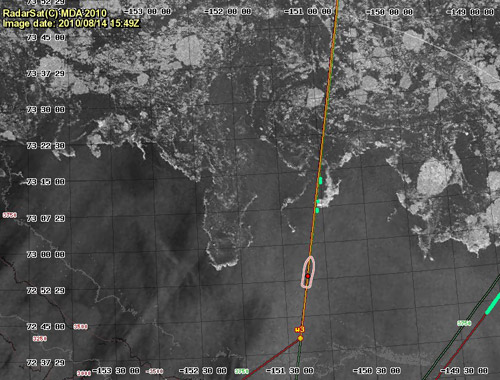
As we made our way towards our meeting with the Louis south of the ice edge I checked recent satellite imagery to see what the ice situation looked like. One of the layers we can add to the Healy Map Server is from a satellite that uses Synthetic Aperture Radar (aka RadarSat) to analyze the sea surface. Rough surfaces reflect more radar back to the satellite and look brighter while smooth surfaces reflect back less radar and so look darker. With a bit of help from our ice analysts I've practiced recognizing patterns of open water and different types of ice in these images. Calm water looks the darkest on the image. Waves show uniform patterns in comparison to more chaotic ice patterns. Thick jumbled ice looks pretty bright while flat thin ice is fairly dark. One feature visible in this image is the ice edge which was tightly packed by several days of strong southerly winds bunching it up. Beyond that was a mix of ice conditions and open water leads.
 RadarSat imagery on the Healy Map Server showing our approach of the ice edge near 73° N, 151° W. The red dot in the white ship outline is the Healy's position at the time, an the red & orange line is our navigational track line to steer along.
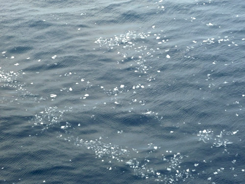
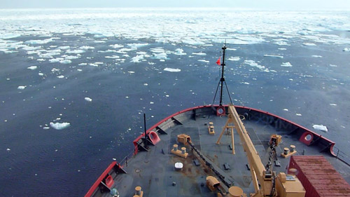
The water had more and more small bits of ice bobbing around as we neared the ice edge. Soon there was a white line visible along the horizon which steadily grew larger and brighter as we approached. We passed by the port side of Louis and swung into position to break a channel through the tight ice edge and beyond into the sea ice north of about 73° Latitude. There were some pretty big chunks to get through and the ship bounced around quite a bit making bumping, scraping, groaning, and banging noises that would be alarming on anything other than an icebreaker. We left red hull paint on some of the larger pieces as evidence of our passing. Since then ice conditions have varied, including thin rotten ice that offers little resistance to thick cakes and pressure ridges that nearly stop the ship, requiring the engines to rev up and send serious power to the twin 16-foot propellers to get us through. Amongst the ice are patches of open water ranging from a few meters to several kilometers wide. A great bonus in the ice is the possibility of seeing polar bears. Yesterday evening I thrilled to see 3 polar bears walking along the edge of a distant large ice floe- a mother with two year-old cubs.
 As we neared the ice edge the sea was littered with more and more small bits of ice bobbing in the waves.
 Recent strong southerly winds had packed the ice into a tight edge. Instead of a gradual transition we went from open ocean to tight ice nearly instantly.
 Occasionally a very dirty piece of ice will stick out like a sore thumb amongst the gleaming white ice pack. This is ice that picked up a lot of dust or mud on or near shore before drifting back out to open water. As it melts the sediment on shore ice is concentrated, making it look so dark.
http://
SPECIAL FEATURE:
Why does the RadarSat provide more reliable ice imagery than visual satellite images on our cruise?
As we left Barrow the Louis was far ahead of us, steaming towards the ice about 4 knots (the speed dictated by their seismic equipment.) They were about 30 nautical miles below the ice edge. We had about 120 nautical miles to reach the ice edge. How fast did we have to go in order to get ahead of Louis to break ice for them?
That's all for now! Best- Bill

