Speed 3.8 knots (kts) Course 80.1° Location Eastern Canada Basin near Northwind Ridge, 76.34° N, 152.11° W Depth 3840 meters
SPECIAL FEATURE DISCUSSION:
(see previous journal for the questions.)
When the sky is clear, visual satellite images give a fantastic look at ice conditions but days like that are exceptions rather than the rule in the Arctic. Radar can penetrate the typical fog and overcast, so RadarSat imagery is more reliable than visual satellite images for evaluating ice conditions.
(For our icebreaker race problem, remember: Nautical Mile = nm, Nautical Miles Per Hour = Knot = kts) The Louis had 30 nm to cover at 4 kts. Thus, her trip to the ice edge would take: 30 nm / 4 kts = 7.5 hours
So the Healy had 7.5 hours to beat the Louis to the ice edge 120 nm away. So we take our distance of 120 nm / 7.5 hr to get a minimum speed of 16 kts. to reach the ice edge with the Louis.
Another way to look at this is that we had 4 times farther to go than the Louis, so to make it in time we had to go 4 times faster than them. If they were going 4 kts then we would have to go 16 kts.
On our actual race up from Barrow the Healy fired up 3 engines to crank up to the ice edge at 17 kts which is about top speed for this ship. (For speeds up to 10 kts or so in open water the Healy can run on one engine for fuel economy. She rarely runs on all three engines as that consumes around 700+ gallons of diesel per hour. No extra speed is gained by running the fourth engine- it is an example of the ship's many redundant systems since it must be totally self-reliant in the Arctic. No tow trucks to call up here!)
TODAY'S JOURNAL:
Yesterday we ended a long track line by reaching the edge of the Northwind Ridge, a submarine feature about 290 nautical miles long trending nearly north-south (a mid-line along the feature going north bears about 13°.) The Northwind Ridge is found along the western side of the Canada Basin. The two features provide a nice study in contrast. The Canada Basin is exceedingly deep and flat, its floor an example of an abyssal plain. Abyssal plains are the smoothest and flattest major features on the Earth's surface and cover over half the planet, thus in surface area exceeding all other landforms and sea floor features combined. If scaled to the same size an abyssal plain would be far flatter and smoother than a pool table. They are typically 3000 - 6000 meters deep. For long stretches of yesterday's transect we were in water near 4000 meters (about 2.5 miles) deep, with very little variance in the depth for hours at a time.
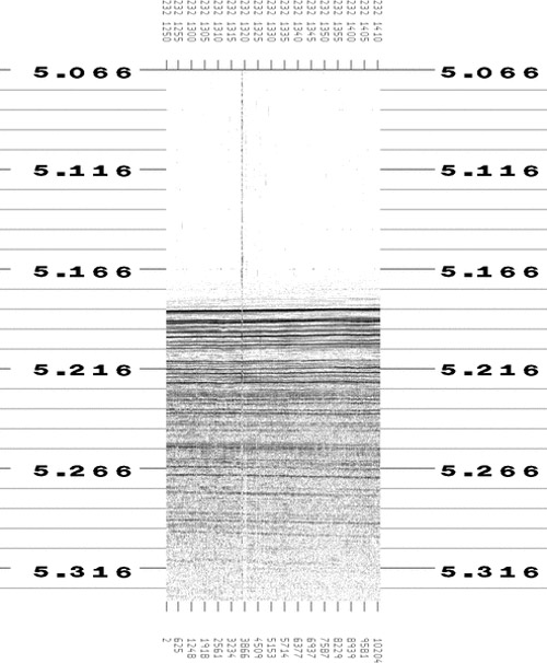 This is one hour's worth of subbottom profiling in the Canada Basin from our single beam chirp sonar. For hour after hour this was the way the display looked as we crossed the abyssal plain. The y-axis units are seconds, measuring the round-trip time of sound waves from the ship to the sea bed and back. The vertical 'hiccup' is what we see when ice or bubbles from breaking ice passes under the hull, interfering with the sonar.
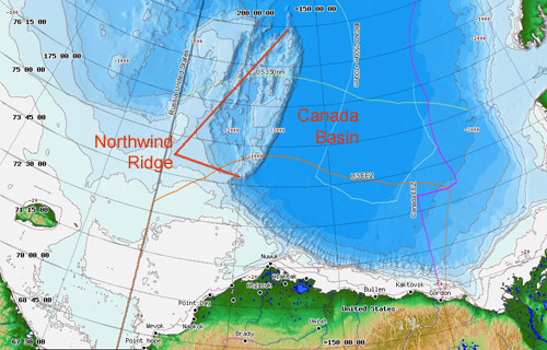 Regional map from the Healy Map Server showing the general locations of the Northwind Ridge and Canada Basin.
In the evening that all changed as our track took us over the Northwind Ridge. Most large submarine ridges like the famous Mid-Atlantic Ridge can be attributed to sea-floor spreading. While nearly completely submerged, such mid-ocean ridges form the world's longest mountain ranges. As tectonic plates pull apart along these divergent boundaries magma is close to the surface or even erupting in submarine lava flows, cooling to form new crust. Such areas are also termed constructive plate boundaries as new crust is made in these places. Hot, young crust is less dense than old, cooled crust and so these areas float higher on the Earth's mantle than most oceanic crust, creating the shallower mid-ocean ridge systems that traverse the world's oceans somewhat like stitches on a baseball. As newer crust is rafted away from hot spreading centers it gradually cools and becomes more dense, inevitably subsiding to a lower level. Add millions of years of crust formation, continued spreading, and deep sea sediment deposition that eventually blankets nearly any previously-existing relief and you get a deep, flat, smooth, nearly featureless muddy abyssal plain.
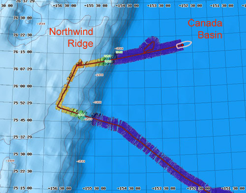 Our track line and multibeam sonar swath over the Canada Basin & Northwind Ridge. On the multibeam, purple is the deepest (almost 4000 meters) while orange is the shallowest (around 1000 meters.) The gaps in the sonar swath are usually due to ice interference. The loop detour on our path away from the Northwind Ridge was due to seismic system repairs being made on the Louis. We detoured to launch another drift buoy and when they were set to go we looped back to resume the track line.
The Northwind Ridge, however, does not appear to be a part of the Earth's network of divergent plate boundaries, at least at the present time. The story of its formation is a bit of a mystery with the remote location and relative inaccessibility of the ridge no doubt contributing to the lack of a complete picture of the geologic processes that formed it. Whatever its origin, it has a very well defined eastern edge that rises abruptly from the flat Canada Basin. Much of the crest of the Northwind Ridge is shallower than 1000 meters and its shallowest areas are less than 500 meters deep. In some areas it is fairly flat-topped but the ridge also has other interesting bathymetry including small submarine peaks and valleys along its length. Some of the flat-topped areas have puzzling circular depressions that show up on high-resolution multibeam swath sonar. At times they appear isolated but along one stretch of our track last night there were several lined up somewhat in a row on the port side swath of our multibeam sonar bathymetry.
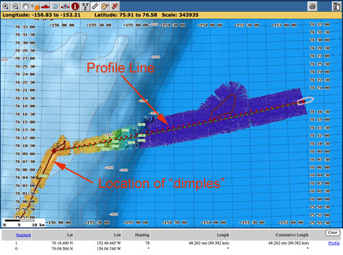 A zoomed-in portion of our track line off the Northwind Ridge back into the Canada Basin. The location of the line of
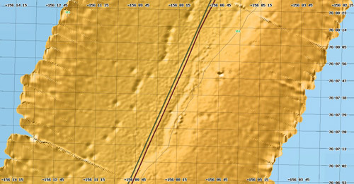 A puzzling line of dimpled round depressions were imaged on our port side by multibeam swath sonar as we traversed northeast along the Northwind Ridge. The sonar swath here is about 2.3 nm (4.3 km) wide and the dimples are around 125 meters across.
Last night and early this morning we turned back eastward (and a bit north, course now about 80°). The sea floor rapidly dropped back down under us and flattened out as we once again found ourselves in the Canada Basin over its abyssal plain. All of this happens unseen under our hull while our view above sea level over the last few days has been about the same- ice, water, and fog and occasionally the Louis following behind a mile back. Our expected track should take us about 120 nm out into the Canada basin and then northwest to touch again on the Northwind Ridge near its northern end before departing farther into the Arctic Ocean.
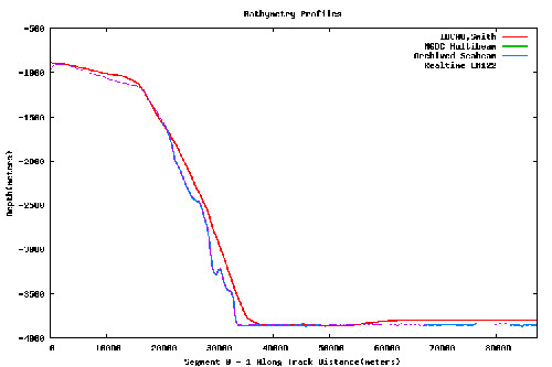 A sea-floor profile of our track off the Northwind Ridge into the Canada Basin. See two images above for location of profile line. The red line is from the general area bathymetry map but the blue and purple lines are from more detailed multibeam sonar bathymetry. Both show the abrupt drop from relatively shallow water (less than 1000m) on the ridge to deep (nearly 4000m), flat water in the Canada Basin.
SPECIAL FEATURE:
While abyssal plains are very deep, there is one notable ocean floor feature that can get much deeper. What is it?
Why is our multibeam sonar swath wider when we are in deep water (purple sections) than when we are in shallower water (orange sections)?
That's all for now! Best- Bill

