Yesterday, the satellite phone came on board on the third trip of the zodiac, so I stayed on the ship and worked on sending my journals and pictures. The satellite phone is very "persnickety” so it took me about an hour and a half to send 14 emails (8 with images) and to receive 6. Of course, that was only 22 minutes of actual satellite time…
 Embarassed
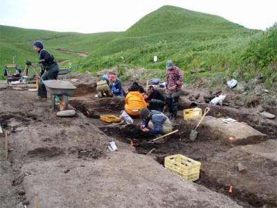
All of the other Americans, many of the Russians and three of the Japanese scientists all went ashore to help finish up the excavation that Valery Shubin and several other archaeologists from the Sakhalin Regional Museum, and Matt Walsh, an archaeology undergraduate student from our group had been working on for nearly three weeks. The excavation site was large – 4 meters by 6 meters and as deep as 1 meter in some places.
**Ainu Creek Excavation Site **
 Shelby Anderson, Dani Plante, Colby Phillips, Nick Shankle, Taku Osaka,
Mike Etnier, James Taylor and Ben Fitzhugh (left to right) work at the
Ainu Creek excavation on Urup Island, Russia.
(Photo courtesy of Matt Walsh)*
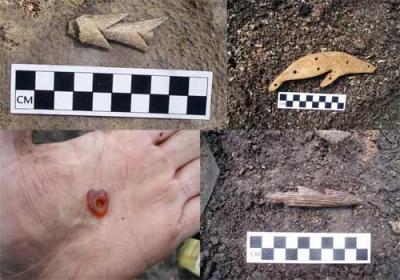
The Ainu Creek site was one that we had visited and done some excavating last summer as well. It is a particularly rich site with a lot of bones from a wide variety of animals, such as albatross, eagle, whale, shark, seal, otter and other birds and fishes, as well as some amazing artifacts from the Jomon to Okhotsk era, including hunting equipment, such as harpoon points and fishhooks, other tools, decorative items and pottery. The volume and diversity of archaeological material made it a particularly interesting site for a more extensive excavation this year.
**Ainu Creek Artifacts **
 Some samples of the Okhotsk, Epi-Jomon and Jomon age artifacts uncovered at the Ainu Creek excavation site on Urup Island. Upper Left: A bilaterally barbed bone harpoon point Upper Right: A fur seal effigy carved from bone Lower Left: A bead carved from amber Lower Right: A unilaterally barbed wood harpoon point (Photos courtesy of Matt Walsh)*
As you can tell in the image of the excavation site above, the site, which is partially a midden(or garbage pile) and partially a house pit, is right in the middle of a road that has been constructed toward the interior of the island and eventually to the lighthouse on the southern tip of Urup. That there were bones and artifacts literally "falling out” of the road cut is one of the ways that archaeologists were able to find the site and determine that it was a very promising one.
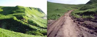
Unfortunately, in the time between last year’s excavation and this year’s, there had been quite a bit of additional road work – the road had been widened from a small, narrow, two tire track road to nearly three times that width. This meant that had been heavily bulldozed along its edges and the road surface had been graded down to bare dirt, with all of the material that was removed from the road bed scraped to one side.
Ainu Creek Excavation Site 2006 & 2007
 Left: The Ainu Creek excavation site in 2006 - center of the photo,
just to the edge of the narrow, two tire track road. Right: The Ainu Creek
excavation site as it was found in 2007. The road has been
significantly widened by bulldozing and the archaeological site has been disturbed.*
This roadwork resulted in the top 30 centimeters or so of the site being significantly disturbed – meaning that the artifacts and faunal remains of different ages have been removed from their original setting or context and all jumbled together. When this happens there is a lot of valuable information that is lost for archaeologists. They can still recover and look at the artifacts, but often they are less able to determine the age of the artifact and cannot learn anything from the other artifacts or items that would have been found in the same area or occupational period in order to construct the story of the people who lived there. A lot of the valuable clues have been erased.
This is one of the reasons that archaeologists are concerned about excavating a site in an organized and documented manner – because the simple act of digging up the site illuminates as well as erases the context at the same time and if it is not done properly, then you may only be erasing the information as you recover the artifacts.
Late in the day, the shore team packed up the camp gear, the excavating equipment, all of the archaeological samples and their personal packs and started bringing them back to the ship. This procedure took until well after dark, because they wanted to use every available moment of daylight to work on the excavation site.
As soon as everyone was on board, the Captain had the crew weigh the anchor and we began heading north to Simushir. The channel crossing between Urup and Simushir is fairly wide – it took total of about 9 hours. Once again, the rougher swell in the channel prevented me from being more than horizontal for most of it today.
Now we are anchored off the shore of the southern Simushir at a location called Mil’na Bay. We are picking up a team of volcanologists from the Institute of Marine Geology, who have been working here for about two and a half weeks.
Tonight we head to the northern end of Simushir, to a site called Vodapadnaya, where the rest of the archaeology team and I will go ashore tomorrow morning. We will set up a field camp and work on that site, where we originally made a test pit excavation last summer, for the following eight days.
More from Vodapadnaya in a day or two! Da Svidanya! Misty

