Today I learned how to determine where recent tsunamis have been. It is kind of like a tsunami Easter egg hunt.
Tanya, Katya, Jody, Bre and I headed north along the beach to the furthest cape that we could see from camp – about 1.5 km – to try to measure the run-up and inundation, or height and distance inland, of the recent tsunamis and measure topographic profiles every 250 meters along the beach.
In November 2006 and again in January 2007, there were significant earthquakes (larger than magnitude 6.0) off the Pacific coast of the Kuril Islands in the Kuril Trench. Each of these earthquakes produced a tsunami as indicated by tide gauges on Sakhalin Island, Kamchatka Peninsula and at other locations farther away. The KBP geology group has a tremendous opportunity both to measure the extent of these tsunamis and to compare the beaches before and after the event at several island locations that we visited last year in the Kuril Islands.
We started at the point farthest away from the camp and worked our way back. When we found a point that we wanted to measure – one that was about 250 meters from the last location, had good representative features and was not too difficult to traverse up and down, our first task was to find the highest run-up of the tsunami waves. This was the Easter Egg Hunt part!
We could easily see some of the damage caused by the tsunami at lower levels – eroded beach faces and turf, ripped up small alder trees, seaweed and sand deposits, sea urchin shells, and displaced rocks.
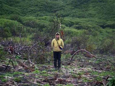
 Bre MacInnes stands in front of a tree which has large pieces of seaweed that were caught in its branches as a tsunami wave passed. Bre is 5 foot, 5 inches tall…
*Bre MacInnes stands in front of a tree which has large pieces of seaweed that were caught in its branches as a tsunami wave passed. Bre is 5 foot, 5 inches tall… *
Matua was once a fairly major Japanese military base in the Kuril Islands primarily leading up to and during World War II. After the War, the islands were turned over to Russia and in 1946 there was a significant eruption of Sarychev Peak, the island’s main volcano. Much of the equipment and fortifications here were abandoned and for the most part buried by beach deposition and/or volcanic debris.
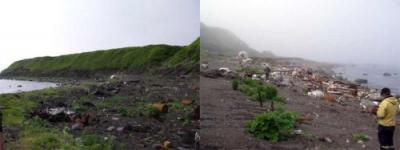
Today, however, the beach is littered with the rusted metal elements of defense – barrels, beams, nuts and bolts, wheels, wires and the twisted remains of unidentifiable vehicles. Much of this has been "exposed” by the erosional effects of the tsunamis.
 On Left: A view toward our camp on Matua from the north. Along the beach you can see the now-exposed rusted remains of World War II era military equipment. Along the terrace you can see the area of erosion that gives an indication of the tsunami’s height. On Right: A view toward our camp on Matua from the south. On this end of the beach the exposed military equipment is even more significant. In addition, some of the rocks that are here – like the one that Jody Bourgeois is standing next to in the middle of the picture – are covered with bryozoans and seaweeds that grow beyond the low tide line, indicating that they have been pushed a great distance by the force of the tsunami wave.
On Left: A view toward our camp on Matua from the north. Along the beach you can see the now-exposed rusted remains of World War II era military equipment. Along the terrace you can see the area of erosion that gives an indication of the tsunami’s height.
On Right: A view toward our camp on Matua from the south. On this end of the beach the exposed military equipment is even more significant. In addition, some of the rocks that are here – like the one that Jody Bourgeois is standing next to in the middle of the picture – are covered with bryozoans and seaweeds that grow beyond the low tide line, indicating that they have been pushed a great distance by the force of the tsunami wave.
At its furthest reaches inland, the strength of the tsunami wave is not enough to erode plants. So a little beyond the significantly eroded and barren areas, plants are still growing. Underneath the plants, we could see, however, where the dead vegetation from last winter had all been pulled into parallel lines running back toward the beach with the wave’s retreat.
So to find the maximum inundation and run-up of the tsunami, we would climb through the underbrush and look for our "Easter eggs”. At the very end of the wave’s flow, as it slows down and retreats, the lightest floating materials are deposited – things like small bits of Styrofoam, plastic bottles, seaweed or sea urchin shells. When we found something like this, we would mark it with a piece of plastic flagging tape and then search laterally along the same elevation from the beach for more "Easter eggs”. When we had found enough pieces of convincing evidence, we would measure the topographic profile from about 1-2 meters beyond that line to down to the water level.
To make a topographic profile, we use a 5-meter scaled stadia rod, a tripod, and a surveyor’s leveling instrument, called the nivelier – which is Russian for "level”. The nivelier allows us to measure the height on the stadia rod along a horizontal line as well as gives us numbers that we need to calculate the distance to the stadia rod. This way we can move up or down a slope, measure the height on the rod relative to the eyepiece of the nivelier and determine how far away the rod is from the nivelier. Using this information, a graphic representation of the topography of the surface can be made.
When the rod is too low to be seen by the nivelier, then we move the instrument to the downhill side, take a reading that allows us to tie the new set of readings to the previous set, which is called the "back shot”, and then continue taking readings all of the way down to the water level.
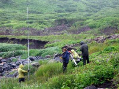
 The tsunamist group works to measure a topographic profile along the Pacific side of Matua. Misty Nikula is holding the stadia rod, which is being read by Jody Bourgeois with the nivelier. Katya Kravchunovskaya is recording the readings and Tanya Pinegina is recording general observations. (Photo courtesy of Bre MacInnes)
*The tsunamist group works to measure a topographic profile along the Pacific side of Matua. Misty Nikula is holding the stadia rod, which is being read by Jody Bourgeois with the nivelier. Katya Kravchunovskaya is recording the readings and Tanya Pinegina is recording general observations. (Photo courtesy of Bre MacInnes) *
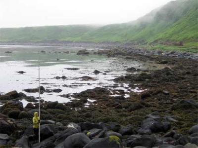
 Misty Nikula holds the stadia rod on the boulder-strewn beach of Matua’s Pacific Coast. In the distance you can see some of the erosion on the terrace face caused by the tsunamis. (Photo courtesy of Bre MacInnes)
Misty Nikula holds the stadia rod on the boulder-strewn beach of Matua’s Pacific Coast. In the distance you can see some of the erosion on the terrace face caused by the tsunamis. (Photo courtesy of Bre MacInnes)
When the topographic profile measurements and calculations are complete we can tell how far the tsunami wave traveled vertically, called the run-up, and horizontally, called the inundation. And if we are lucky enough to have profiles of the beach from BEFORE the tsunami then we can compare these with the new ones to also see how the beach has been altered by erosion.
On this south-east Pacific side of Matua, we made a total of 17 profiles along about 4 km of beach. From these measurements, we have determined that the tsunami waves reached a maximum run-up of 12-16 meters on the northern end of the beach and 14-21 meters on the southern end of the beach. These numbers are uncorrected because they have not been adjusted for the tide levels on the day of the tsunami versus the day of our observations.
Along most of this part of the island, the high terrace creates a narrow beach and since the tsunami did not go over the top of the terrace, the inundation is not very far from the ocean.
The difference between the run-ups on the two ends of the beach could be caused by offshore bathymetry differences including the smaller offshore island. A shallower bathymetry, or water depth, in the near offshore area would create a lower wave run-up because the wave "breaks” sooner and loses energy more quickly as it comes on shore.
Tomorrow we will hike to Ainu Bay, where a shore group of geologists and archaeologists spent several foggy days last year, and we will be able to compare the beach before and after the tsunamis.
Da Svidanya!
Misty

