August 6 is Bre’s 25th birthday! Everyone on the island of Matua was invited to a party to start at 7pm at the geology shore camp. (Okay, so that’s only 12 people that we know of…) The day dawned sunny and clear just as Bre had asked for … she just left out one detail – wind.
We set out "early” – 9 am – for Ainu Bay with a full plate of tasks that we wanted to accomplish - re-measure Profile 2 and take tsunami deposit samples. Yes, that IS only two tasks, but it would take us the entire day.
We hiked over to Ainu Bay to find that it was just as sunny and clear on the Sea of Okhotsk side, but it was also EXTREMELY WINDY! Not the "Ah, this is a nice brisk, refreshing wind” kind of wind, more like the "OUCH! The wind is sandblasting my face!” kind of wind. Bre uttered "Holy Crap!” on this day many times, but generally in response to nearly being blown off the top of a hill rather than at the tsunami damage.
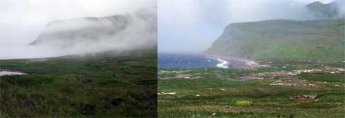
Since we had the opportunity, Bre and I scampered up to where I had helped dig a snail shell midden last summer to take another "comparison” photo.

*On Left: Ainu Bay, Matua on August 9, 2006 from the side of a hill just to the south of the bay. On Right: Ainu Bay, Matua on August 6, 2007 from nearly the same place. The Bay has been altered dramatically by tsunamis created by the November 2006 and January 2007 earthquakes off the Pacific coast of the Kuril Island chain. *
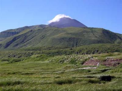
The other, oft-repeated words out of nearly everyone’s mouth were "Volcano!” as Sarychev Peak had decided to make an appearance for Bre’s birthday, as well. Apparently, last year, during the 3 days that the shore camp worked on Matua, the volcano was never seen.
 Sarychev Peak rises majestically over Ainu Bay on a clear day on Matua. This is the Kuril Islands’ most active volcano. You can see that the rain filtering down from the typhoon the previous day is still being “steamed off”.
Sarychev Peak rises majestically over Ainu Bay on a clear day on Matua. This is the Kuril Islands’ most active volcano and you can see rainwater filtering down to its hotspots and being "steamed off”.
[Note – That last picture is for you, Jesse.]
Jody, Bre and I headed down to the beach, made a plan for where we wanted to take them and then as quickly as possible, took new measurements of the beach topography up to the ridge area. We "took heroic measures”, as Jody put it, to work in the fierce wind, which made it nearly impossible to hear each other, extremely difficult to hold the stadia rod still for each reading and constantly pelted our hands and faces with coarse sand. When we got to into the beach ridge area, where it was a little more "peaceful”, and before we headed on to measure the rest of the profile, we paused to take samples of the tsunami deposits. Jody took her own heroic measures and raced back down to the beach to get a sample of the active beach for comparison.
There are two important elements to present-day tsunami deposits – their depth and their composition at different distances from the beach. To take a tsunami deposit sample, a clear tube is pushed down through the "sandy” layer of what was left behind by the tsunami and into the soil beneath. The soil helps to hold the "sand” in the tube as it is lifted up and removed. The depth of the deposit is measured, the soil is removed from the bottom of the tube and then the deposit is placed into a sample bag so that observations of its composition (grain size, color and mineralogy) can be made back in the lab.
 *A series of images showing how a tsunami deposit sample is taken.
Left: Jody Bourgeois pushes a clear tube down through a thick layer of sand that has been left behind by the 2006/2007 tsunamis at Ainu Bay, Matua.
*
*Center: After the tube has been pushed about 0.5-1 cm into the soil beneath the tsunami deposit, is twisted slightly and gently pulled up and out. The soil is more compact than the sand and helps to hold the sand inside the tube so that it can be measured and collected. *
Right: Jody checks the "soil seal” on the bottom of the tube to be sure that all of the tsunami deposit was collected. This particular sample was also preserved by cutting down the tube and capping both ends so that the stratigraphy of the deposit could be studied later as well.
Tsunami waves push landward and deposit whatever materials can be moved – sometimes this is beach or marine sand, sometimes it is larger pebbles or other material. At Ainu Bay, it was often cinders from volcanic deposit layers just below the turf that had been exposed by the tsunami’s own erosion.
Bre continued taking samples of deposits along the profile and Jody and I worked to finish measuring the profile until it was time to head home to prepare for the party.
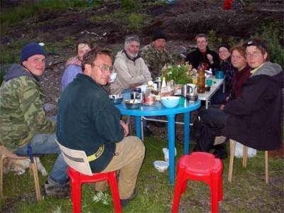
The entire population of the island showed up and enjoyed Jody’s World Famous Pancakes, tushanka (canned beef) with rice and beans, a salad of cabbage, apples, cucumbers and almonds with a dressing of mayonnaise, lemon, salt and pepper, bread, gorbusha (canned salmon) and a cake that Kiril made of pechenya (cookies). There were also many traditional toasts for Bre. Andre Kharlamov also played guitar and sang many beautiful and a few humorous songs in Russian for us. A very successful field birthday party!
 The entire population of Matua shows up for Bre MacInnes’ 25th birthday party on August 6, 2006. Seated around the table are (left to right) Kiril Ganzey, Nadia Razhegaeva, Sergei Chirkov, Dima Frolov, Nikolai Vasilenko, Bre MacInnes, Misty Nikula, Katya Kravchunovskaya and Tanya Pinegina. Jody Bourgeois is taking the photo. Andre Kharlamov was away from the table at the time the photo was taken and Andre Klitin arrived later to help celebrate.
*The entire population of Matua shows up for Bre MacInnes’ 25th birthday party on August 6, 2006. Seated around the table are (left to right) Kiril Ganzey, Nadia Razhegaeva, Sergei Chirkov, Dima Frolov, Nikolai Vasilenko, Bre MacInnes, Misty Nikula, Katya Kravchunovskaya and Tanya Pinegina. Jody Bourgeois is taking the photo. Andre Kharlamov was away from the table at the time the photo was taken and Andre Klitin arrived later to help celebrate. *
On the morning of August 7, after a late start of 10:30 am, Jody, Bre and I returned one last time to Ainu Bay for field work. Bre used a GPS unit and altimeter to trace and measure the highest tsunami run-up of the as well as the current water edge, while Jody and I cleared off two erosional faces and described the stratigraphy. The day had begun clear and sunny (tank top weather even!), but by about 3 pm began to turn cold and foggy. Layers are the name of the game in the Kuril Islands!
This was my last day of field work on Matua. The next day, August 8, I was going to hike across the island one last time early in the morning to meet up with Dima and Nikolai when they went back to Iskatel so that I could spend the day getting caught up on uploading images and journals for the website. Tanya, Katya, Sergei, Jody and Bre would spend part of the day doing the last bits of field work and then pack up the shore camp and rejoin me and the rest of the field crews on the Iskatel late in the day.
Da Svidanya! Misty

