Today I took an eight hour bus ride through Denali National Park to mile 66, the stop for the Eielson Visitor Center. The first 16 miles of the only road in and out of Denali was paved and had two-lanes. After the 17th mile, the road became gravel, bumpy and dusty, and only one lane, so the bus stopped often to allow other buses to pass us in the opposite direction. We saw mama grizzly bears with cubs, red fox, magpies, caribou, Arctic ground squirrels, red squirrels, snow shoe hares, hawks and falcons. The sun was shining, but clouds still hid the elusive peak of Denali – the mountain at 20,310 feet. Only 30% of visitors to the park actually see the peak, and I, unfortunately, was not part of that lucky percentage.
One of the questions that was posed was how do you define the Arctic? Denali has an arctic tundra (another journal) and is considered an arctic desert (yet another journal) so why isn't this part of Alaska considered to be Arctic? Why is it considered to the "Sub" Arctic?
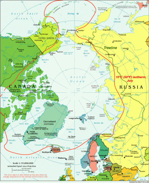
Denali is located at roughly 63 degrees N. With research, I found several definitions of what constitutes the Arctic. The common definition is the Arctic is the region located above 66N, the Arctic Circle. This circle, the Arctic Circle, marks the latitude above which the sun does not set on Summer Solstice, June 21, or rise on Winter Solstice, December 21, and thus has six months of continuous daylight and six months of continuous night. This region consists of the Arctic Ocean, adjacent seas, Northern parts of Alaska, North Canada, Finland, Greenland, Iceland, Sweden, Russia, and Norway.
Other definitions include the Arctic as the area north of the Arctic tree line, where the landscape is frozen, or is covered in permafrost, and is treeless. And finally, the Arctic can be defined by its temperature – a zone where the average daily summer temperature doesn't rise above 50 degrees F (or 10 degrees C).
Denali has many Arctic characteristics and is a great place to continue my expedition research on the environment that I will soon be part of. I have to admit, I miss nighttime darkness. The sun doesn't set like I am used to, and at first it was difficult to sleep. I have somehow managed to acclimate and have slept very well regardless of the fact that it is still light out. I give credit to the fresh air and the great hikes I have been on. And the topic of 24 hours of light is yet again... another journal entry. Stay tuned!
The following map is from the National Snow and Ice website.
 Map of the Arctic. This map shows three definitions of the Arctic: the tree line; the 10 degrees Celsius isotherm, and the Arctic Circle at 66° 34' North. Map courtesy The Perry-Castañeda Library Map Collection. Treeline added at NSIDC based on information from National Geographic 1983, Armstrong et al. 1978, and Young 1989.

Add new comment