Here’s a question: What is this?
 A curious, almost artistic pattern. What is it?
Sometimes a new or larger view really helps put things in perspective:
 The larger view shows the delta of the Kolyma River from satellite imagery. The thousands of lakes are believed to fill the ancient delta as the river migrated east. Cherskiy is along the river, near the lower right, just above where the river turns northward.
The picture above shows the larger view shows the delta of the Kolyma River. The thousands of lakes are believed to fill the ancient delta as the river migrated east. The brownish-area of lakes is about 120 km (75 miles across). Cherskiy is along the river, near the lower right, just above where the river turns northward. Those lakes all look the same to the uninitiated.
As scientists, sometimes we need a bigger picture to understand what is happening.
On the first day we arrived at the Northeast Science Station, the members of the Polaris Project were joined by a couple of researchers, literally a husband-wife research team. Eugene and Marina were about to set off on a trek across that myriad of lakes in the ancient Kolyma River delta to study the birds of prey there. We were amazed by the boldness of this adventure – crossing the innumerable lakes seemed incredible to us, especially since Cherskiy is only a few meters above sea level. How could anyone find their way across and back?
As it turned out, Eugene and Marina know those lakes from decades of studying there. Their understanding of the region, including the history, the local peoples, and the abandoned shelters across the area, is remarkable. They returned and gave us a tremendous presentation of their trip. During their presentation, they showed us pictures down into the nests of peregrine falcons. We wondered, how did they get those shots?
The Coolest Scientific Tool – EVER!
As it turned out, the use a remote-controlled helicopter with a mounted camera to look down into the nests on trees or on cliffs. At the request of Sasha Kholodov, they agreed to come take arial pictures of the permafrost core drilling operation.
 Eugene and Marina demonstrate the helicopter they use to observe nests on trees and cliffs.
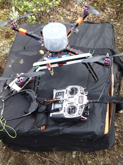
 Notice the camera on the front of the helicopter.
Wait! It gets better – it comes with awesome glasses!
The coolest part of the set up is that the camera is directly linked to a pair of glasses that shows what the camera sees in real-time. Also, the glasses make the wearer look like a superhero!
 Eugene models the glasses connected to the helicopter’s camera.
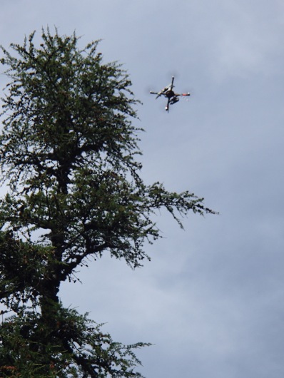
As Eugene and Marina demonstrated the helicopter, they showed its maneuverability among the treetops, perhaps 30 feet over our heads.
 A view of the helicopter above the trees showing the unique perch it can attain.
The helicopter is light and portable and it started quite a lunch conversation on how we could justify the purchase of one of these (per person?) for our research needs. The uses could be endless! Just think of the perspective it might add. How would you use one?
 A better view of the helicopter, glasses, and remote control set-up.
Stay curious my friends! - Mark Paricio
Don’t forget, you can follow the blogs of the students on the Polaris Project with me at: http://www.thepolarisproject.org.

