Science Update
Last night we tried to reach our next sampling station before the sea conditions worsened. Unfortunately, when we got on station, the sea conditions had worsened to the point that we were unable to sample with the rosettes. The science team collected water samples using the flow-through system in the wet lab and we set a course towards land. The seas were very rough as we made our way south towards the South Shetland Islands. We awoke to wind, ice, blowing snow, lots of wind, seabirds, and seals.
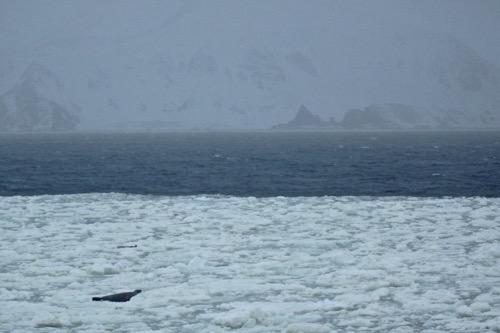
 The fog, wind and snow make for an interesting view of some of the South Shetland Islands. A seal rests of the sea-ice while the RVIB Palmer approaches a seawater sampling station near Livingston Island.
The plan today is to move forward with distributing incubation samples (today is day 5) and to use the rosettes to collect new seawater samples at stations closer to land this afternoon. I realize that I have mentioned these stations quite a few times. While some of the stations are random and chosen by the science team because of their interest in the location, others are predetermined sampling stations that are part of an on-going research program called the Palmer Long Term Ecological Research Network.
The Long Term Ecological Research Network
A number of our sampling stations used during this research cruise are sampling stations within the Palmer Long Term Ecological Research (PAL LTER). This LTER is located near the only U.S. Antarctic research station north of the Antarctic Circle, Palmer Station. Palmer Station in located on Anvers Island on the west side of the Antarctic Peninsula.
 Palmer Station Antarctic on Anvers Island. Photo by Nell Herrmann (PolarTREC 2012), Courtesy of ARCUS
LTERs are diverse ecosystems in the United States, Puerto Rico and Antarctica where ecological processes are studied over an extended period of time. This network was created in 1980 by the National Science Foundation (NSF). There are 26 LTER sites including those in the Arctic, Arizona, Georgia and Plum Island, Massachusetts. Each year, more than 1000 scientists and students study ecological processes within these areas. Some may study life processes, sea ice variability, the movement of materials and energy through the ecosystem or biodiversity. Data collected in these LTERs is collected in a open-source database available for use by other researchers.
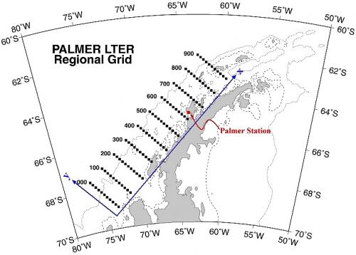
The PAL LTER has been studied since 1990. The area is divided into a grid system with specific locations marked as stations. The 900km X 200km (560mi X 124mi) grid includes areas that allow scientists to study sea-ice habitats, oceanography, pelagic (offshore) ecosystems and nesting sites for seabirds all within the LTER. The grid is composed of parallel transect lines divided into sampling stations. The grid lines are 100km (62mi) away from each other and the stations along each transect are separated by roughly 20km (12mi). The data collected during this research cruise will be added to the growing database of information collected each year. Through long-term research, scientists are able to look at trends in data and create ecological models to better understand how the ecosystem can handle short-term and long-term changes.
 The Palmer LTER grid is made up of parallel transect lines divided into sampling stations. Image courtesy LTER Network.

Comments