Winds rushing at 50 knots, snow swirling through the air and hair whipping your eyes so fiercely that you can't keep them open long enough to see where you are walking... just another day at the office in the Bering Sea. While weather conditions are usually less than ideal out here in the land of " The Deadliest Catch", today's windstorm added a whole new element of fun to the multi-coring experience. Luckily, the storm reserved it's full wrath until the equipment was back on deck. Five people worked to get the two tarps secured around the Multi-corer as strings swatted us in the face. We slipped and slid all over the deck and snow pelted us but in the end it was wrapped up like a Christmas present and we headed inside to work with the mud.
A few hours later we were back on the fantail cleaning up our mess. Take a look at what the scene on the back-deck looked like as we hosed-off the materials that we process the samples with! We might have considered some tethers if we had been out much longer.
http://
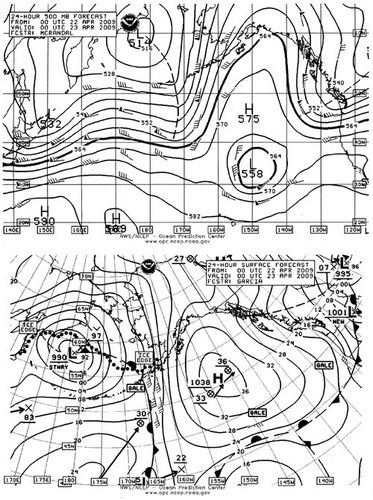
Chief Rieg is the weather expert for the Healy. After I came inside, I decided to head to the source to find out what was causing this weather and more importantly, what was to come. The chief uses information given to him from both the National Weather Service and the Naval Marine Forecasting Center in Pearl Harbor Hawaii to piece together a weather report for the Captain and crew. The charts that he looks at give him high- altitude (like 20,000 feet high!) weather information for 96-hours into the future.(Pop quiz O-A students: 96 hours= How many days?)
When I spoke to him earlier today he had a rather grim forecast for me. Looking at troughs, dips and lines, scattered across a map of our quarter of the world, he translated for me "The winds are going to intensify. In the next four days there will be low pressure underneath us. We'll have one day of calm before another storm moves in on Saturday. It's gonna be pretty rough today, tomorrow and Thursday." He showed me how the winds flow from high to low along pressure ridges. The lines on the chart get closer together as the winds intensify. We are sitting in the midst of the closest lines on the map. Whoo-hoo!
 This is the kind of map that the Chief looks at when preparing his forecast for the Captain. Notice the different pressure patterns. Where the lines get close together you can expect a wild ride!
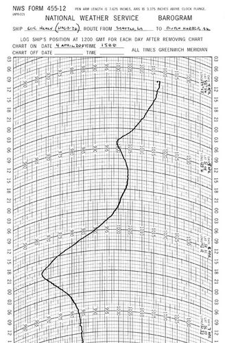
 This rollercoaster drawing is a printout from the ship's barometer, a barogram. Dips show areas of high pressure dipping into areas of low pressure. At this area of change, the wind speed increases so hang on!
I asked Chief Rieg what kind of weather is most significant in terms of Healy operations. "Up here in the ice, nothing really matters too significantly. Precipitation reduces visibility. Wind and waves are the biggest factor. We want to avoid areas of strong winds that produce high waves. When the barometer starts to drop and wind changes direction, we know we're in for some strong weather." While the Coast Guard generally tried to steer around 15-18 ft seas, often times they are forced to head straight into them on rescue missions.In addition to getting information from the National Weather Service, Chief Rieg also provides weather service officials with a picture they might not otherwise have. He sends them observations every three hours. "If you live in Missouri you know the weather because people in California have already observed it. Nobody is out here in the ocean observing the weather and telling us what's coming!"
The message that I was getting from my conversation with the Chief was to batten down the hatches, contemplate Dramamine and hang on for the ride! Stay tuned!...

