Cruise Day 1 Speed 0 knots (kts) Course n/a Location At Dock, Dutch Harbor, Alaska, 53.90° N, 166.53° W Depth n/a
GO DEEPER DISCUSSION: (see previous journal for the questions.)
As mountain glaciers carve their way down slope they produce wide, U-shaped valleys. Sharp ridges between these valleys are called arêtes. The curved cliffs at the upper end of a glacial valley is a cirque. A steep peak left as glaciers erode the sides of a mountain is a horn.
TODAY'S JOURNAL:
For the last few days we have been in major set up & stow mode. Anything needing to be set up has to be dug out of a hold & brought up to the lab, and anything that won’t be in use right away has to be stored back in a hold. I kind of feel like a friend asked me to help them move, and then another the next day, and once more yesterday! In preparation for this afternoon’s departure, we wrapped up work in the holds last evening by strapping everything down. A huge difference between a ship’s holds and a warehouse is that when the ship is underway it can undergo lots of motion. If you want your stuff to stay where you put it and remain in good shape, it is a good idea to secure it against rolling (side to side tipping motion) and pitching (front to back tipping.)
Yesterday morning, several members of the science party and coast guard crew did a test cast of a CTD (a cast is when an instrument is sent overboard into the water.) There will be lots more to follow about CTDs as the cruise goes on, but here are the basics:
* CTD stands for Conductivity, Temperature, and Depth.
* Electrical conductivity of water is used to determine its salinity (salt content), which can be plotted along with temperature vs. depth in a given water column.
* CTDs also are used to recover water samples from various depths using Niskin bottles (with spring-loaded caps) or GO FLO bottles (with ball valves), which allow water to flow through while they are being lowered or raised, but can be closed at a desired depth.
* CTDs can also deliver other instruments down and up through the water column.
* We have numerous CTDs aboard, both for primary use and as spares.
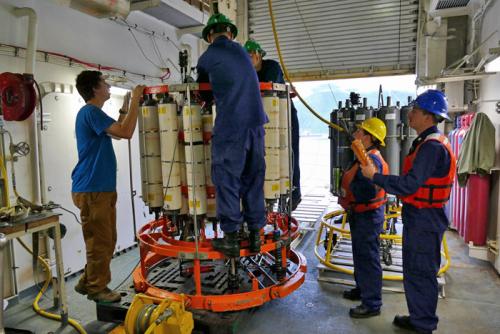
 A team of scientists and Coast Guard crew getting the 36-bottle CTD ready for a test cast in the starboard staging bay. Each of these bottles can recover 10 liters of sea water at a chosen depth, and the CTD electronically returns data on salinity & temperature vs. depth.
 The 36-bottle CTD rosette ready for deployment. Note that the tops of the Niskin bottles are open- the same mechanism is also on the bottom of each bottle so water flows through when the CTD is being lowered and raised. When a desired depth is reached, a remote signal from the control room triggers the end caps to close on demand, securing a water sample for study.
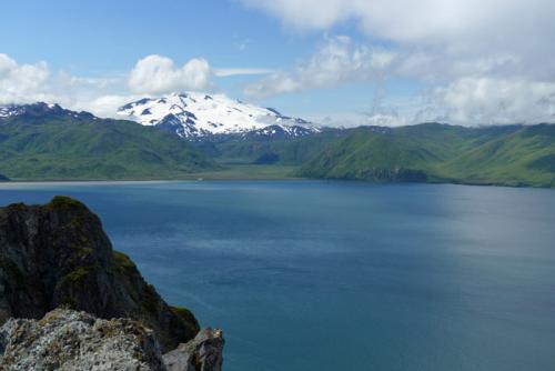
I was able to get my last few hours ashore until mid-October yesterday afternoon, so I decided to hike up Mt. Ballyhoo on Amaknak Island which is adjacent to the dock where we are moored. It was a steep hike up but the views were well worth it. I was able to sample wild berries similar to raspberries and watch numerous Arctic Ground Squirrels romping around on the tundra. Atop the peak I explored the ruins of a World War II era US Army base called Fort Schwatka that housed ~1000 troops and four 8-inch guns 897 feet above sea level that could sweep the strategically significant entrances to Dutch Harbor and Unalaska Bay. Spotting bunkers atop the sea cliffs not only look out over the Bering Sea but provide excellent viewing of Mt. Makushin, an active volcano that is the highest mountain on Unalaska Island.
 An Arctic Ground Squirrel pauses in its activities to ponder my presence atop Mt. Ballyhoo on Amaknak Island, Alaska.
 This bunker sits atop a sea cliff nearly 900 feet above sea level at Fort Schwatka on Amaknak Island, Alaska. It was used to spot incoming ships and direct gunfire from the fort’s battery of four 8-inch guns, each capable of firing 240-lb. shells up to 20 miles.
 Mt. Makushin, Unalaska Island, Alaska is an active, glaciated volcano that rises 2,036 meters (6,680 ft) above sea level. Its last eruption was in January 1995.
This afternoon we are setting sail, heading into the Bering Sea to begin our voyage. We have our first sampling station scheduled after dinner, to fill and rinse CTDs in preparation for subsequent water sampling operations.
 On the hike back down Mt. Ballyhoo I was in the unusual position of watching a young Bald Eagle soaring from above. For a moment it crossed in front of the distant USCGC Healy, which I thought was pretty cool!
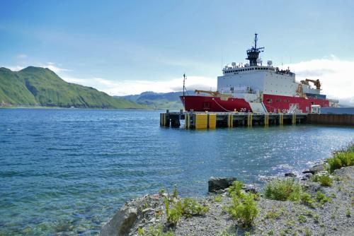
 Healy’s home for one more night, tied up to the wharf in Dutch Harbor, Alaska. After we unmoor we should be at sea for 65 days!
GO DEEPER!
A liter of sea water weighs about 1.035 kilograms (1035 grams.) When the 36-bottle CTD comes back full, how much heavier is it than when it went overboard empty? (Hint- make sure to read the photo captions.)
That's all for now. Best- Bill


Comments