Cruise Day 6
Speed 11.3 knots (kts)
Course 63° (ENE)
Location Bering Sea, approx. 43 nm SW of St. Lawerence Island
Depth 86 m
GO DEEPER DISCUSSION: (see previous journal for the questions.)
Station #2 is a shelf station, meaning the sampling takes place in the shallow water of the continental shelf. We ended up taking a position in ~40 meters of water. This makes the sampling operations go faster because there isn’t as much “wire time”, which is the time it takes for gear to lower and raise through the water column. The GEOTRACES carousel also only carried 6 GO FLO bottles, so setting it up and taking it down was pretty quick compared to doing all 24 bottles. (GO FLO bottles are similar to Niskin bottles but have ball valves instead of spring-loaded caps, and can be pressurized for sampling through filters etc. in the lab.) Finally, not all of the sampling protocols that take place on a full station happen on a shelf station.
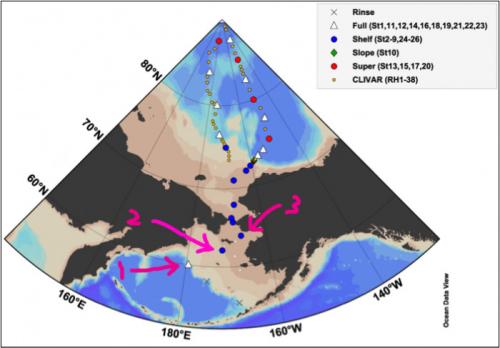
 Note that Station 2 is in the lightest-colored contour, which is water less than 50m deep.
TODAY’S JOURNAL:
Last night we arrived at Station 2 right on schedule at midnight. The science crew began getting the GEOTRACES carousel ready at about 11:45 pm so when the ship got into position we were already set to cast.
 Last night’s sunset at around midnight was really nice!
GEOTRACES sampling goes first on each station because that group is testing for the most sensitive trace metals and thus gets first crack at the water to avoid contamination as much as possible. The last sampling operations (multicore and Thorium/Radium) are the least subject to contamination.
 The GEOTRACES cast took place against the sunset last night, going in a little after midnight and wrapping up a little after 1am this morning.
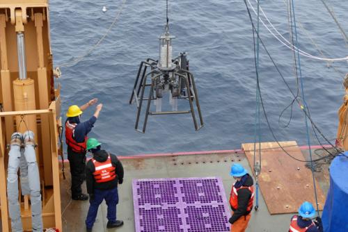
We tried the first deployment of a piece of gear called a Multi-corer in the shallow waters of Station 2. The device looks like some kind of space lander, which in a way it is I suppose. The device is lowered off the aft A-frame crane all of the way to the bottom. There, the 4 tubes visible under the frame are pushed down into the seafloor somewhat like sticking straws into pudding. Note the light gray stack of metal plates above the frame- these are lead weights that can be added or subtracted to fine-tune the amount of weight pushing the core samplers into marine sediments. As the device is lifted back towards the ship, lids pivot into position under the tubes to trap the samples instead of letting them slip out into the water on the way back up. It turned out that the bottom here was a bit too firm (sandy instead of muddy), so we didn’t get useable samples this time.
 Deploying the multi-corer off the fantail of USCGC Healy.
We wrapped up Station 2 around 11 am today and now we are hooking around St. Lawrence Island towards Station 3 south of Alaska’s Seward Peninsula. We have several more shelf stations coming up before we reach deeper water somewhere in the Chukchi Sea north of the Bering Strait.
 Our first two stations and anticipated next station in the Bering Sea.
GO DEEPER!
The team sampling for elements like Neodymium, Thorium, and Radium go last in the station sequence and like to joke that they run the “dirty” sampling. While they are really just as meticulous as the other groups, why are their samples less prone to contamination than GEOTRACES? (GEOTRACES samples are analyzed for trace metals such as Iron, Zinc, Cobalt, Manganese, Arsenic, Selenium, Aluminum, and Mercury.)
 US Arctic GEOTRACES Station 2 Sampling Plan.
Aloft Con web cam updated every hour
Healy Track
That's all for now. Best- Bill

