Cruise Day 13
Speed 1 knot (kts) (on station)
Course 352° (N)
Location SW Flank of Mendelev Rise, approx. 312 nm NNE of Wrangel Island, Russia
Depth 2191 m
GO DEEPER DISCUSSION: (see previous journal for the questions.)
With a 53 day half-life, samples of Beryllium-7 decay pretty quickly. Even if the samples from the last few days are immediately analyzed upon our return, over half of the 7Be will be gone since our cruise runs through mid-October Scientists will factor in the date of each sample collection, but won’t want to wait long to count up their 7Be once they are back in their home labs to retain as much of the unstable isotope for study as possible.
TODAY’S JOURNAL:
We’re still on the same station as yesterday, nearly done with the last sampling cast. Last night’s GEOTRACES cast wrapped up around 2am, but I got to experience a couple of neat things by staying up late. First of all, I had the pleasure of having a mid-rat meal. No, it wasn’t the center portion of a large rodent. Rather, mid-rat is short for midnight rations. Since the ship runs 24 hours and some people sleep for much of the “regular” day, food is offered from 11pm to midnight. Some of the crew and science team start their day with mid-rats and others have the equivalent to dinner at this time.
The second spiffy event from last night was the first polar bear sighting of the expedition. All hands got a page announcing the sighting, and soon the port side of the ship was lined with eager-eyed observers. (We all have pagers to find us if needed and to spread news like this rapidly.) I went up to the bridge deck to get the highest viewpoint and someone pointed out the proper ice floe to scan perhaps a mile out. With the help of my binoculars I saw the slightly yellowish-white mammal striding along the ice. After soaking it in for a bit I started scanning more icy areas and was very excited to spot another polar bear, this one a little bit closer and swimming through a lead between ice floes. Soon it clambered up onto the ice and gave us nice looks before easing back into the water and swimming on to its next destination. This morning I spotted a distant ringed seal on the edge of an ice floe. As one of the polar bear’s favorite prey species, it makes sense that we would see both in the same area.
 The second polar bear of the cruise came along soon after the first was spotted. It appeared to be a very well-fed individual!
As we continue extensive water sampling on each station, I thought I’d concentrate more on the electronic guts of our sampling rosettes. At the heart of the rosettes is an electronics package called a CTD. You may recall from earlier posts that this stands for Conductivity, Temperature, & Depth (and that conductivity is used to calculate salinity.) Sometimes, when we say that we are doing a CTD cast it really means that we are going to deploy a water sampling rosette with Niskin or Go Flo bottles. The CTD on board a sampling rosette is critical because on the way down through the water column salinity and temperature are charted vs. depth to identify different layers of water and plan where the samples will be collected as the rosette travels back up to the ship.
CTDs can be deployed on their own without any water samples being collected, or used with other types of equipment. For example, the 7Be pump I discussed yesterday goes down with a CTD, as do other devices I’ll get to later in the cruise. On our rosettes we actually have several other instruments as well that measure variables beyond what a simple CTD can. Here’s a shot of what is at the base of the GEOTRACES sampling rosette:
 The electronics package at the base of the GEOTRACES sampling rosette.
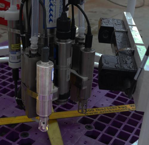
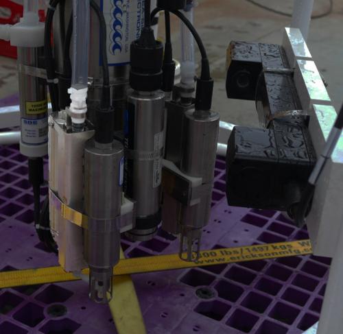
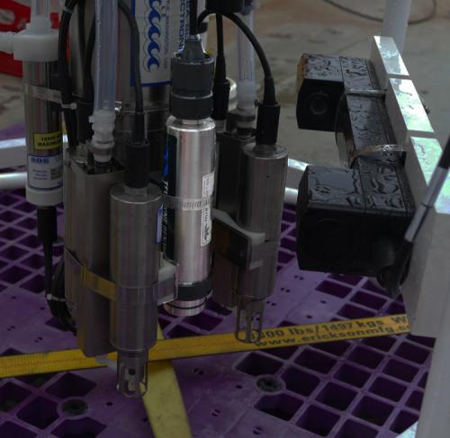
Zooming in a bit, I’ve highlighted a pump component in the next shot. This pumps water first through a temperature sensor (second photo below), then through a conductivity meter (third photo below), and finally through a dissolved oxygen sensor (fourth shot below.) The pump ensures a constant flow rate over these sensors (important as the rosette experiences starts & stops and different speeds on any given cast.) The sensors return more accurate data when they have a constant flow rate running through them. The GEOTRACES rosette has two each of pumps, temperature sensors, and conductivity meters. This lets scientists assure their data quality by comparing the values of each CTD “set”. One of the pump circuits ends by running through the dissolved oxygen sensor.
 One of two pumps on the GEOTRACES sampling rosette is highlighted in this photo.
 Here’s one of two temperature sensors, which is the first instrument in the pump circuit.
 Water next goes through the conductivity meter.
 On of the pump circuits on the GEOTRACES sampling rosette includes a dissolved oxygen sensor.
There are a few other sensors on the GEOTRACES rosette. One is called a chlorophyl fluorometer. It emits blue light at 470 nanometers, which causes chlorophyl to fluoresce (glow) red at 685 nanometers. By measuring the strength of the fluorescence scientists can tell how much chlorophyl is in the water, indicating the amount of phytoplankton present.
 The GEOTRACES rosette chlorophyl fluorometer.
Another instrument on the GEOTRACES rosette is called a beam transmissometer. Basically, it shines a beam of light through a gap, measuring how much of the light is detected on the other side. This can determine the amount of particles in the water- the clearer the water, the more light makes it across the gap.
 The GEOTRACES rosette beam transmissometer.
A final key piece of electronic gear on any sampling rosette is the altimeter. This is a sonar unit that tells the scientists conducting the cast how far above the bottom the rosette is. This is more reliable than measuring how much cable has been played out because currents and winds can cause the ship and the sampling rosette to move in different directions. It is entirely possible (and I saw this in practice last night) to have more cable played out than the water depth under the ship without having the rosette touch bottom. So to get accurate depths, especially if near-bottom water is to be collected, the altimeter data is critical.
 The GEOTRACES rosette altimeter.
GO DEEPER!
Sharp-eyed readers may note that our position changed by a few miles, even though we are still on the same sampling station. How do you account for this?
Aloft Con web cam updated every hour
Healy Track
That's all for now. Best- Bill

