Cruise Day 16
Speed 10 knots (kts)
Course n/a
Location Mendelev Rise, approx. 380nm NE of Jeannette Island, Russia
Depth 2178 m
GO DEEPER DISCUSSION: (see previous journal for the questions.)
Although it belongs to Russia, Jeannette Island was discovered on an 1881 US Arctic exploration mission. The island was named for the expedition’s ship, the Jeannette. A party sledded over the ice to visit the island and at the time claimed it as US territory. The claim was never formalized, though, and now the US recognizes it and other nearby islands as Russian Territory.
TODAY’S JOURNAL:
We’ve just departed from the long, full station that began yesterday. Our position changed just a bit during the station as we drifted south and west in the pack ice, but we’ve crossed back above 80°N and should be up on the “top of the world” for several weeks now. As yesterday wore on the clouds dissipated and we were treated to blue skies and brilliant, snow-frosted ice floes. In contrast, this morning I walked out to see total overcast and light snow driving in to the starboard side of the ship, and miniature forests of hoarfrost sprouting from lines (ship-talk for ropes), railings, and cables exposed to the wind. A ringed seal popped its head up in the lead of open water we had selected for the station, but far & away I think the highlight for everyone aboard was a polar bear that got within 30 meters of the stern by my estimate. It lingered near the ship for over half an hour, giving everyone ample photo opportunities and looks into its inquisitive behavior. I also shot video of the bear, so stay tuned for when I get home and can post this (and many other) videos.
 We had an amazing up-close encounter with this polar bear yesterday afternoon when it investigated the big red ship that was interloping in its world.
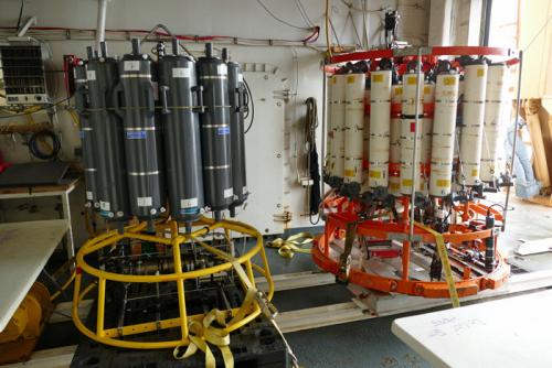
In prior journal posts I’ve features aspects of the GEOTRACES sampling routine, using their own sampling rosette and winch system from the aft A-frame crane. We have another water sampling group aboard known as the ODF team that is doing another series of water sampling and analysis on the cruise from the starboard A-frame. ODF (Oceanographic Data Facility) scientists and technicians are running what is known as repeat hydrography stations. This means that they are getting samples from the same positions of stations conducted in 1994 and 2005, to see how the water column in 2015 compares. Data like this is critical for seeing potential changes and tracking long-term fluctuations or movements in water masses. Repeat hydrography has been a key tool to understanding much of the world’s oceans, but due to the difficulty of getting access to the Arctic Ocean, this represents some of the first repeat hydrography done in these high latitudes. On a full station like the one we just wrapped up, GEOTRACES and ODF alternate wire time from the aft A-frame to the starboard A-frame several times, interspersed with pumping operations to fill out station time. When both GEOTRACES and ODF repeat hydrography cruises were being planned, it made the most sense to do both from the Healy on this cruise instead of trying to run separate cruises to many of the same areas this summer.
The ODF team is using two sampling rosettes. One is a 12-bottle rosette, the other a 36. On the 12-bottle rosette each Niskin Bottle holds 30 liters, while the 36-position rosette holds 10 liter Niskin Bottles. So each rosette can return the same volume of water, 360 liters (12 x 30, or 10 x 36.) Having more bottles lets the 36-position rosette sample at more levels in the water column, but the 12-bottle rosette can bring up larger samples from a given level more easily when looking for a substance occurring in very scarce levels in sea water.
 ODF is using two sampling rosettes on this cruise, one with ten 30-liter bottles and one with thirty-six 10-liter bottles.
The ODF rosettes have a few other neat instruments along for the ride that aren’t on the GEOTRACES sampler that I profiled on August 21. One such instrument on the 36-bottle rosette is called a Chipod (as in the Greek letter chi-pod.) There’s one on the top and on the bottom of the rosette frame, and each measures micro-currents in the water around the rosette. Also on the big rosette is a RINCO Optode, which optically senses dissolved oxygen. A third instrument unique on our cruise to the 36-bottle array is a plankton profiler. It has two red cylinders that project light into a plane with a known surface area in between the cylinders. A camera looks down from a calculated distance onto the projected plane of light to record the density and types of plankton encountered along the cast.
 This is the bottom-mounted Chipod on the 36-bottle rosette.
 Here you can see the top Chipod projecting above the orange rosette frame as it comes back up from a cast.
 The RINCO Optode is used to optically measure dissolved oxygen.
 The plankton profiler has two red cylinders (one visible here) that illuminate a plane between them. A downward-looking camera (silver cylinder with black rim and red lens) records the density and types of plankton imaged on within the plane.
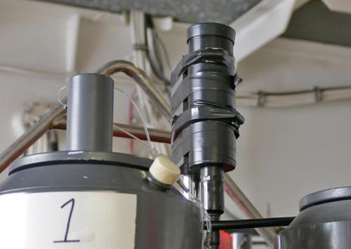
The 12-bottle rosette has the addition of a PAR sensor atop its frame. This stands for Photosynthetic Active Radiation, and it measures the light available to phytoplankton for photosynthesis throughout the water column. There is also a PAR sensor on the ship, so comparisons can be made between light reaching the ocean’s surface and what penetrates to various depths.
 The PAR sensor at the top of the 12-bottle rosette measures light available for photosynthesis by phytoplankton.
GO DEEPER!
Why are some instruments, like the upper Chipod and PAR sensor, mounted above the rosette frame instead of underneath the bottles like most of the electronics?
Aloft Con web cam updated every hour
Healy Track
That's all for now. Best- Bill


Comments