Cruise Day 34
Speed 6 knots (kts) Course 219° (SW) Location Makarov Basin, ~146 nautical miles south of N. Pole Depth 2783 m
GO DEEPER DISCUSSION: (see previous journal for the questions.)
To get ice that is mostly clean with a dirty layer, perhaps it began to form in clear cold shallow water. At some later point, a storm stirred up sediment, and the resulting muddy water froze underneath the clear ice. Finally, the sediment settled out, and/or the ice drifted into deeper, clearer water, where more clean ice formed under the dirty layer.
There are also scenarios where spring runoff from an Arctic river could deliver muddy water onto or under clean ice, creating a dirty layer when it froze.
 Here’s a piece of mostly clean ice with a dirty layer running through the left side. It was left churned up in our wake as we were breaking ice on our way south from the pole.
TODAY’S JOURNAL:
We concluded the ice station immediately following another full sampling station this morning, and are again heading south. The Healy is making good progress and it again feels like being in an earthquake for hours on end as we crunch through thick ice and pressure ridges. I went down to get a load of laundry going, and the deck with the washing machines is located just below the waterline so the sounds there are pretty amazing when we are breaking ice. On any normal ship, hearing the crunches and feeling the jolts run through the whole ship would be cause for donning survival suits and deploying life rafts, but on an icebreaker in the Arctic Ocean it is par for the course.
Before I left on this expedition I had an idea to see what a hiking compass would do up here in the far north, but I hadn’t gotten around to it yet. Two days ago, I got a really nice note from Ms. Steiner’s students in response to a Go Deeper! question I posed about which way a compass would point at the North Pole. She wrote:
…My students were interested that the compass needle would point South, toward magnetic North, when at the North Pole. We wonder if you have a regular compass, and get a chance to get out on the ice again, you could take a picture of what it looks like. Of course that would be cool paired with a pic of the GPS coordinates! Thanks!
I thought this sounded like a grand idea, and I began right away by testing what the compass would do onboard the ship. First, I checked our shipboard navigation system, which we can access online on the ship’s closed network, to see how the ship was facing (we were stopped on a sampling station at the time.) The ship can determine direction using a gyrocompass, which works on principles of the gyroscopic effect of a fast-spinning disc and the Earth’s rotation to find true north. We also use GPS to determine our position, and when we are moving our direction can be derived from this as a double-check against the gyrocompass.
I went out to the helicopter deck at the back of the ship, oriented my compass to match the ship’s heading, and saw this:
 My compass on the helicopter deck of Healy. The N on the compass is pointing essentially at true north, based on the ship’s gyrocompass reading, while the north needle is pointing at approx. 45°, or Northeast.
Then I walked up to the bow and repeated the process. Here’s what I saw:
 My compass on the bow deck of Healy. Again, N on the compass is essentially true north based on our gyrocompass, while the north needle is pointing at about 160° (SSE.)
So the helicopter deck reading was about 45° (NE) and the bow reading was about 160° (SSE.) This shows why regular compasses are pretty much useless on steel ships. On Healy, all of the 16,000 or so tons of steel creates magnetic field effects onboard that are greater than the Earth’s magnetic field, throwing off a magnetic compass needle.
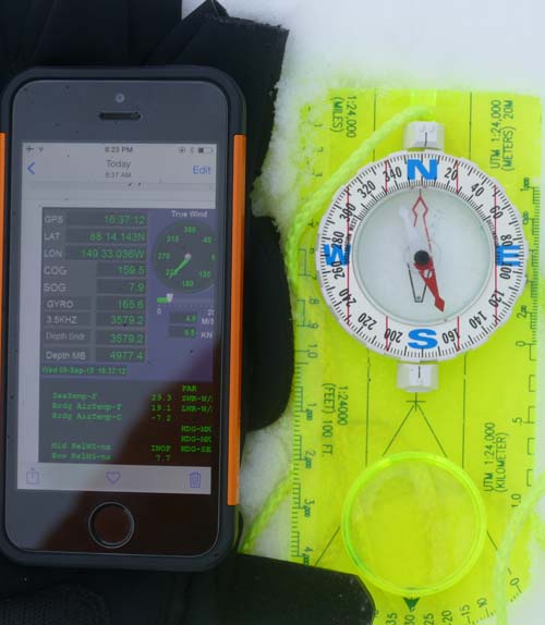
I suspected that the ship’s readings would be haywire, but was very interested in what I would see out on the ice as Ms. Steiner’s students suggested. When I went out on the ice this morning I brought along my compass and a picture of our navigation screen showing our location, gyro compass heading, and course over ground. Then I lined up the compass again so that N would be pointing at true north (as best as my eye could approximate it compared to how the ship was pointing.) I was expecting the needle to point somewhere southeast, in the direction of the magnetic north pole from our position. But here’s what I found:
 Compass reading on the ice, approx. 100 meters from USCGC Healy, 87° 46.568’ N, 149° 02.183’ W. N on compass is pointing to approximately true north based on the ship’s gyrocompass, and needle is reading ~64° (ENE.)
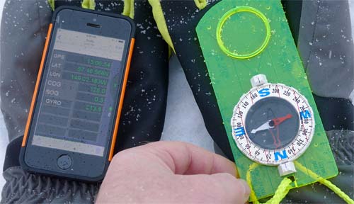
 Compass reading on the ice, approx. 100 meters from USCGC Healy, 87° 46.568’ N, 149° 02.183’ W. After tilting the compass around for a few seconds I repeated the process, with N pointing approximately true north. This time the needle reads ~262° (W.)
Any time I tilted the compass around, it pointed a different direction. I made a movie of this going on (the pictures above are screen shots from the video), and it shows that essentially the needle will just stay wherever it gets pointed by tilting or rotating the compass.
GO DEEPER!
The behavior of my compass on the ship didn’t surprise me, but out on the ice I wasn’t expecting the needle to be so willy-nilly. Why do you think the needle didn’t really point in any particular direction, instead just staying wherever it happened to be pointing from tilting or rotating the compass?
Aloft Con web cam updated every hour
Healy Track
That's all for now. Best- Bill

