This journal is brought to you by...
 This journal is brought to you by...
- Amanda Bags and her Kindergarten class at Riverwood Elementary
- Mrs. Mungle and Mrs. Aviotti and their Kindergarten class at Saint Agnes Academy and St. Dominic School
- Mendel Academy homeschool
- Jana Whitt's 3rd grade class at Bon Lin Elementary School
Here’s a question…
How does a teacher from Memphis end up working with amazing Weddell seals in Antarctica?
My story begins in early 2012, when I was paired with a team of scientists who were studying Weddell seals. Of course, to do our research, we needed to visit the seals’ habitat – Antarctica. More specifically, our team was studying Weddell seals in the Ross Sea near McMurdo Station. Check out this map!
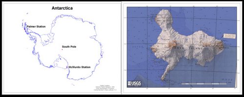 In the first picture, you can see where McMurdo Station is in Antarctica. McMurdo Station is on Ross Island, an island in the Ross Sea just off the coast of the mainland and at the edge of the Ross Ice Shelf. The second picture gives you a nice close-up of Ross Island. Photo credit: Left: Antarctic Digital Database, Right: USGS
A little background about the 2012 study
Before the 2012 project, not much was known about where the Weddell seals go during the Antarctic winter. To tell you the truth, that didn’t surprise me. Antarctica is a tough place to work! Even in the summer it’s VERY cold. But, one good thing about working in Antarctica in the summer is that there is 24 hours of daylight. That was wonderful!
So, what do you think Antarctica is like during the winter months? It’s giving me chills just thinking about it! Ridiculously cold and 24 hours of darkness! Not what most people would consider fun or a habitable environment for conducting scientific research… unless, of course, you are a Weddell seal!
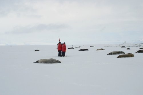 Just look at all these seals lounging about! Photo credit: Alex Eilers MMPA Permit # 17411
So, the research team decided to have the seals gather data about where they go during the Antarctic winter for us. How did we do that, you ask? During the Antarctic summer (January and February), when it’s warmest and the seals are hauled out on the ice resting and molting their fur, the team put satellite tags on the heads of the seals to track their movements. With a little glue and some satellite technology, the scientists were able to track where the seals were going, from the warmth and comfort of their offices.
Pretty ingenious of the human scientists, wouldn’t you say?
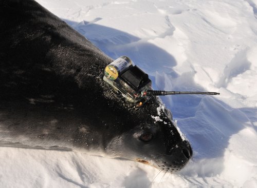 Here’s a close-up of a seal with the satellite tag glued to its head. Photo credit: Dan Costa, MMPA Permit # 17411
Let’s take a little closer look at the tag…
This tag is incredibly impressive. It’s called a CTD data logger, and it measures three things:
- The 'C' in CTD stands for Conductivity. This sensor, indicated by the red arrow, measures the salinity (how salty) of the ocean water.
- The 'T' in CTD stands for Temperature. This sensor, indicated by the green arrow, simply measures the temperature of the water.
- The 'D' in CTD stands for Depth. This sensor, indicated by the blue arrow, measures the water's pressure. Pressure and depth are directly related - so if you know the pressure, you know the depth the seal is diving.
One last thing… How do the scientists actually get the data?
Take a look at the salt water switch, indicated by the orange arrows. These switches tell the tag when to collect data and when to send data. When the circuit is closed (under water), it collects data. When the circuit is open (above water), it sends/transmits data to the satellite.
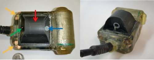 Close-up of satellite tag showing its many sensors. Photo credit: Alex Eilers
The scientists hypothesized that the seals would stay fairly close to the continent, but that turned out to be incorrect! Sometimes, even scientists’ best educated guesses can be wrong. It turns out that seals ventured further out than expected. Take a look at the picture below.

