Yesterday, the Bering Sea once again became a stormy mess. The area where we were sampling, the SL line, was experiencing very high winds and seas. According to NOAA Alaskan Headquarters, we were operating in an area under a STORM WARNING with winds forecasted up to 65 knots and seas to 28 feet. After Science Station SL9 was scrubbed due to the weather, it was decided Healy would head for cover from the storm back in the ice. The ice has a dampening effect on the ocean swells. There were quite a few people not feeling so hot, luckily, I was NOT one of them!
 The Healy takes to the ICE!
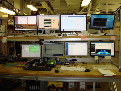
Taking a break from science stations gave me the opportunity to talk with Steve Roberts, the onboard expert in bathymetry and sonars on the Healy. Bathymetry is the measurement of the depth of bodies of water. To use a simile; Topography is to land as Bathymetry is to oceans. Aboard Healy, there are a number of different types of sonars to produce the bathymetric data. Sonar is short for sound navigation and ranging. It is a method of detecting, locating, and determining the speed of objects through the use of reflected sound waves. There are 2 ADCP sonars, a sub-bottom profiler sonar and a multi-beam sonar. These sonars help provide a clear picture of the ocean floor. There are several components to these sonars. The transducer is the component that generates sound and listens for the sound wave to return. The transducers are ceramic plates that are found in the tranducer well. This is an area right against the hull on the forward port side of the ship. The transducer communicates with a piece of electronics called the deck unit. The deck unit communicates to a computer that is housed in the computer lab on the 03 deck. The multi-beam transducers are much larger than the single beam sonars' transducers. They are also mounted on the bottom of the ship but are not found in the transducer well with the single beam sonar transducers.
 Computer bank to monitor the sonar data
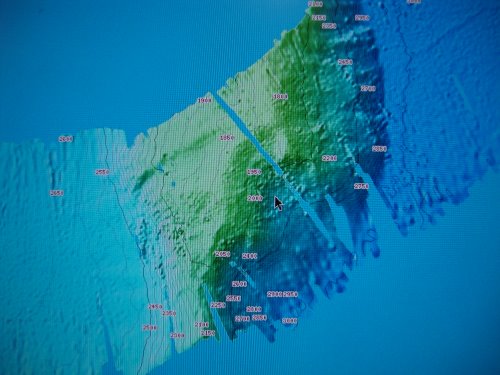
The ADCP sonars and sub-bottom profiler sonar are single point beam sonars. They provide the bottom depth at a single latitude/longitude location. This is a very difficult way to produce a map of the ocean floor. Imagine trying to create a accurate map with only individual data points. The Healy also has aboard a state of the art Multi-beam sonar. This sonar sends out a swath of beams...430 individual beams bow to stern that can produce a very dense, high resolution image. Because the swath is sent out at a fixed angle, the deeper the water, the wider the swath. Find -156 00 00 longitude on the following image. If you follow the line from the 5 in that number, you can see how the sonar line close to the coast is very narrow – the water there is shallow. As Healy traveled out over the continental slope, the water increased in depth and the swath became wider!
 Multi-beam sonar data on the Healy Map Server
The multi-beam has allowed Healy to discover several new seamounts. In fact, almost every time Healy goes into a new area, it discovers a new geological feature. There is so much undiscovered and un-explored in the Arctic. In the following image, you can see one pass over a new area and the ocean bottom went from flat, to a seamount...an unexpected surprise! This feature was NOT visible on any chart or map previously!
 One swath of the multi-beam data discovers a seamount!
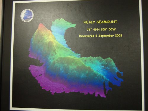
Scientists aboard Healy in 2003 also discovered a seamount for which it was named. Previously charted as a small sea knoll, Mount Healy abruptly rises more than 3,000 meters from the floor of the Arctic Ocean. This is a picture that hangs in the Science Conference Lounge.
 Healy Seamount
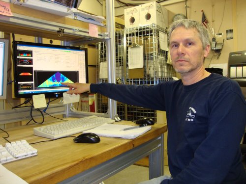
Thank you Steve Roberts for taking the time to explain the Healy's sonar and bathymetry to me! Steve has worked for the National Center for Atmospheric Research (NCAR) for 15 years. He has been on the Healy every year for 14 of those years! He knows the Healy and her sonars!!! Steve has a 4 year degree in Mathematics from Cal State Long Beach. He said he deals with numbers everyday and needs to understand the data that's generated from the sonars, the physics of sound and how to use CTD data to generate the speed of sound to be used for the sonar data.
 Steve Roberts, NCAR, explains the sonar systems
The speed of sound in water is very important since that is one of the principles of which sonar is based. The speed of sound at the surface of the water in the Bering Sea is 1439 meters per second. In more lower latitudes, the speed of sound in water is 1500 meters per second. The speed of sound increases with temperature, salinity and depth/pressure.
New Vocabulary
seamount- An underwater mountain rising from the ocean floor and having a peaked or flat-topped summit below the surface of the sea.
bathymetry - The measurement of the depth of bodies of water.
sonar - Short for sound navigation and ranging. A method of detecting, locating, and determining the speed of objects through the use of reflected sound waves. A sound signal is produced, and the time it takes for the signal to reach an object and for its echo to return is used to calculate the object's distance. The Doppler effect can also be used to determine the object's relative velocity. Electronic sonar systems are used for submarine navigation and for detecting schools of fish. Some mammals, especially bats, use biological sonar to navigate and detect prey in dark conditions, commonly called echolocation.
transducer - any device, such as a microphone or electric motor, that converts one form of energy into another
Question of the Day
Explain why the speed of sound increased with temperature, salinity and depth/pressure.
Stay tuned as we continue our exciting voyage on the USCG Cutter Healy. Until then...
“Live as if you were to die tomorrow. Learn as if you were to live forever.” Mohandas Gandhi

