Teacher/Researcher Collaborations
The PolarTREC program and my experience with NASA’s Operation IceBridge during the 2016 Spring Arctic Campaign in Greenland has reinforced my belief in teacher-researcher collaborations as a powerful tool for engaging students in STEM and giving them the chance to think and explore career possibilities outside of the four walls of their classrooms. One of the most effective ways to engage students in the classroom is to leverage the power of human connection, stories that allow students to feel connected to otherwise “far-off” research they may only encounter in textbooks or online. Teachers should have the opportunity to go on science expeditions, because it allows them to act as a link between students in the classroom and real innovative research.
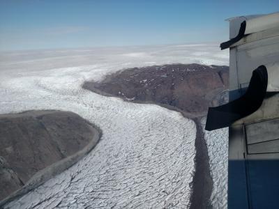 NASA's Operation IceBridge flies a priority land ice mission over the Greenland Ice Sheet, revealing rivers of moving ice and moraine beneath the low flying wing.
It is a way to reinvigorate a classroom teacher’s passion for preparing the next generation of innovators, problem solvers and thinkers, and it is a venue through which students might see themselves or at least find excitement in learning more about STEM discipline they might not have realized existed. That final point was the case for many of my own students who had never heard of airborne science as an option or a tool before my PolarTREC expedition with NASA’s Operation IceBridge.
To provide some background about my project before delving into its impact on my students, my community, and my own perspective it is important to know that Operation IceBridge is a complex machine built of many moving parts, instrument teams, program managers, sea and land ice scientists, flight crew, logistics coordinators, outreach personnel and requires fluid communication with weather centers, flight control towers, and members of the communities out of which science flights are based. Operation IceBridge is the largest airborne survey of Earth’s polar ice and has been collecting data on ice thickness and extent since 2009. Its name stems from its role in maintaining a continuous record of data after the ICESat satellite malfunctioned. It is bridging any potential gaps in data collection before ICESat 2 is ready for launch in 2018.
Expectations and Outcomes
Upon returning from my PolarTREC experience in Greenland, I was very aware that every single day I was in the field at some point, I commented or wrote about how “surreal” the experience was. Each day was more exciting and beautiful and impactful than the last and my heart and soul were full as I experienced the true and pure beauty of our Earth and became a part of a crew who was capturing that beauty and the important information hidden within to build a continuous record of our changing planet. This experience was transformational not only as a classroom teacher, but as an individual and steward of our Earth and on a truly personal level.
Before heading out into the field I created a list of areas of growth. I expected to gain a greater understanding of the instruments used on board an Operation IceBridge aircraft and hoped to develop lessons for my students to introduce them to remote sensing. In order to engage students of all background and ability levels, I was hoping to create an adaptable simulation using Vernier Labquest sensors and I will describe the lesson developed from this experience in the classroom implementation section on outreach.
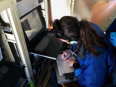 PolarTREC Teacher Kelly McCarthy monitors the Digital Mapping System instrument during a science flight.
I think I was able to grow in my own knowledge of remote sensing and some of the related physics concepts along the way which was extremely important for my own development as an educator. I think what was even more powerful was the fact that the more I learned, the more I realized there was to learn. Thirty days as an educator in the field is enough to create wonderful partnerships with experts that can connect with your students but it is not enough time to learn all there is to know. Thirty days is also just enough to spark a hunger for more information. That enthusiasm as an educator and that drive to be lifelong learner is something students can thrive on as well. I think my own students seeing me out of my comfort zone and being on the same level with me as we learned about airborne science and its role in polar regions was really important for their engagement.
One piece of technical information that I feel helped my students and I understand the airborne science process better is the function of satellite GPS data and a ground station. A video of the ground station located in Thule, Greenland during the Spring 2016 Arctic Campaign is located below.
The Power of Collaboration
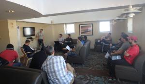 The NASA Operation IceBridge science team & NOAA flight crew meet nightly to finalize logistics & discuss science objectives for next day flights.
A unique aspect of the 2016 Spring Operation IceBridge Campaign was the necessary partnership between NASA and NOAA. Two complex operations working together, communicating, solving problems, and carefully planning each mission to get the most out of each science flight was an incredible process to observe as a teacher. In the classroom, especially in the middle and high school grades, we stress the importance of communication and collaboration in solving problems and working toward success.
Redesign and Flexibility
Some days you are “socked in” (that is, your flight plan is barricaded by fog that will interfere with optical instruments and prevent smooth flight operations); some days you are in the middle of a 100% success rate of data collection (which means for the entire mission, nothing interfered with data collection including cloud cover, etc.)
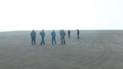 NASA and NOAA science and crew members look for clearing to make a case for a valuable science flight on foggy day in Thule, Greenland. Flexibility is key throughout each science mission.
I vividly remember one of the first flights I was able to participate in involved a glitch in communication between one of the monitors on board and another instrument. In order for our flight to collect accurate data that needed to be fixed before takeoff. Additionally in order to get back to base in time, the window for takeoff was very specific. This was a perfect example of many experts working together to troubleshoot and solve a problem. Flight engineers from NOAA, experts from Kansas State University, and NASA’s Airborne Topographic Mapper engineers worked quickly together to find a solution that worked. This was a clear example of members of different agencies who did not know each other prior to the mission working together toward a common goal. To these scientists and flight crew members, it is all part of the job, but for my students that story was an important motivator for their own team-based projects and assignments.
Engineering vs Science
I feel that this experience also provided me with an excellent example to share with students about the relationship between each of the disciplines in S.T.E.M. For example, the Airborne Topographic Mapper (ATM) team builds all of their own instruments.
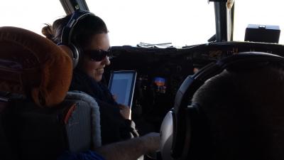 Teacher Kelly McCarthy takes a turn in command on a transit flight back from collecting data on a priority sea ice mission near the North Pole.
They build and fly with the instruments, because assuming they are using the instruments to collect data on long science flights over remote areas, they need to know their machines inside and out in order to troubleshoot any problems that might interfere with data collection and science objectives. The ATM instrument uses LiDAR (light detection and ranging) technology to collect data on surface topography of land and sea ice. The goal of the instrument is to collect said data to be processed and stored for scientific use. But each science flight also provides experimental data to allow the team to improve the design of that instrument. During the 2016 Spring Arctic Expedition, I learned that the team, in particular Engineer Alexey Chibisov, were working on a brand new ATM that would be put into use the following season of science flights. This was the perfect example of STEM in action and the engineering design process, an excellent real-life anecdote to prompt student EDP projects.
Student Outreach
Prior to leaving for the expedition I spent time with each grade level from pre-K through 12th grade in my school to share information about Operation IceBridge and to allow them to create flags or tokens to go to Greenland.
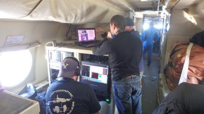 NASA Operation IceBridge at work.
This facilitated engagement in journals and virtual communications throughout the expedition. Immediately after returning from the expedition, we held a school-wide assembly to share the experience with my school. Students remembered our PolarConnect event that happened in the field and engaged in many questions. Students from 8th -12th grade volunteered at an educational booth at our local Heritage Festival to provide the public with informational packets about the science behind OIB.
I was able to link this experience directly back to my classroom in several ways including preparing a lab for 8th grade students in which they simulated an airborne remote sensing campaign over a hidden topography using Vernier sensors.
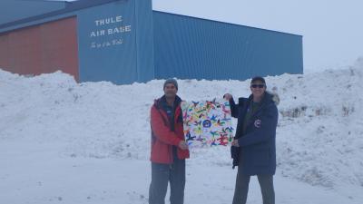 Scientists share student-made flags.
Spending time connecting with NASA Operation IceBridge Scientists via Mission Tools Suite for Education (MTSE) before and after the expedition allowed students important context in their lab simulation. While they used Vernier motion sensors and the speed of sound to map a “hidden” topography on their desktops, they had the context and familiarity of the NASA Operation IceBridge missions to connect that desktop lab to broader applications.
Another way I hope to use this in my classroom in the future is to work with students to work more with the data sets accumulated through NASA Operation IceBridge campaigns. 11th and 12th grade students in my classroom have learned how to access data sets temporally and by specific variables measured in the NSIDC web portal for Operation IceBridge missions, and I hope to facilitate practice in constructing models with that data.
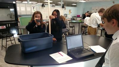 Students simulate remote sensing techniques after interacting with Operation IceBridge Scientists.
One of the challenges in the classroom, especially in creating a data-centric unit that can be adapted to younger grades is making the data more accessible, or creating a clear guided tutorial to extract a small data set for student use.
Google’s MyMaps application is an example of a GIS tool that students can use to create an overlay of the data extracted from NSIDC (collected by Nasa’s Operation IceBridge). Along with the mapping tools used in virtual communications with students from Operation IceBridge via Mission Tools Suite for Education.
Professional Outreach and Teacher to Teacher Collaboration
Along with bringing the experience of PolarTREC and NASA’s Operation IceBridge back to my classroom and students, I have found several venues through which to share the experience with colleagues around the globe. Through virtual interactions using Edmodo and interactions within the PolarTREC journals, I have been able to connect with classrooms and educators across the U.S., in South Africa, the Philippines, and Germany. I have also presented the work to colleagues at our annual Diocesan Conference, co-presented with another PolarTREC NASA Operation IceBridge teacher at NSTA, and provided several community talks.
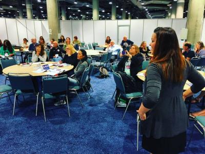 PolarTREC Teacher Kelly McCarthy co-facilitates a workshop for educators at NSTA on using NASA Operation IceBridge data in the classroom.
It has been interesting to share the science and mission of the work being done by NASA’s Operation IceBridge with a variety of different groups, and as an educator, being able to successfully respond to questions or refer individuals to best resources related to the science behind the expedition. Beyond that, it is exciting to see the enthusiasm from fellow educators surrounding the opportunity to connect with the OIB team in the field and learn more about polar science.
I have also been able to develop ideas for lesson plans and curricular materials further by participating in collaborative teacher events such as a Google Hackathon on GEO-education. That experience allowed me to share my PolarTREC experience and ideas-in-development with educators and scientists and received great feedback to further develop projects that use GIS application within them.
We’ll Figure this Out
One of the greatest and most impactful takeaways for my classroom from my PolarTREC experience was the raw, unsolicited advice from scientists, engineers, pilots, visualization experts, an astronaut, and an incredible program manager. The enthusiasm about reaching the next generation of innovators through my experience was tangible and exciting. Often researchers or engineers on board would mention that having a platform to educate students about their work reminds them of its importance and removes any (if there could possibly be!) routine feeling about their work.
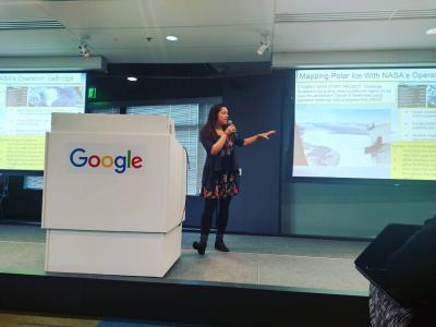 Kelly McCarthy shares and receives feedback on ideas to implement NASA Operation IceBridge content in classrooms using Google Geo-education tools.
Along with the researchers, flight crew and engineers on board the Operation IceBridge project, I had the opportunity to encounter many inspiring individuals throughout the expedition, in particular one individual who made an impact beyond belief. That person was the late Dr. Piers Sellers, who along with sharing as much science content as he could with myself, he shared some of his most important advice for students. Number one was “Don’t be afraid of the hard stuff. Take physics and calculus and work through the challenges that might exist on your first try. Make mistakes, it’s okay. But take them early.” He referenced his past educators with high admiration and really valued the importance of education. Sometimes an experience allows you to meet someone who will make you rethink the problems in our world and reignite your passion for learning. Each of my students know Dr. Sellers’ name and his story.
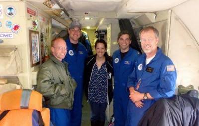 The NOAA Flight crew working with the NASA Operation IceBridge team shared many words of advice for students.
They’ve heard his advice to “take the hard classes,” they’ve read his words and watched his statements on the urgency of climate science. As an educator who reaches hundreds of students each day, the opportunity to work so closely with a scientist who has spent decades working on climate science, flown and planned airborne missions, worked on the International Space Station, and made it his life’s mission to educate and advocate for a better planet was impactful beyond imagination. “We’ll figure this out,” was Dr. Seller’s parting message of hope after a talk he gave at Thule Air Base on our changing, warming planet and the urgency for humans to work together to advocate for our Earth. Along with sharing heartbreakingly beautiful footage of our planet that he took from the International Space Station (and which brought this teacher to tears), the way he spoke of his work on climate change and the importance of education to solve our problems was invigorating.
Looking Toward the Future
I hope to continue to work toward educating my community members and students about the importance of polar science education. I would like to leverage the experience to build polar science curriculum, combining the experience with an upcoming trip to Antarctica. Additionally, I plan to stay in contact with fellow PolarTREC teachers, setting up visits and staying in touch with OIB scientists and NOAA flight crew to construct future outreach events. I hope to collaborate with my fellow Operation IceBridge PolarTREC teachers to propose joint talks at various conferences, especially as we continue to develop our lesson plans and curricular materials further.
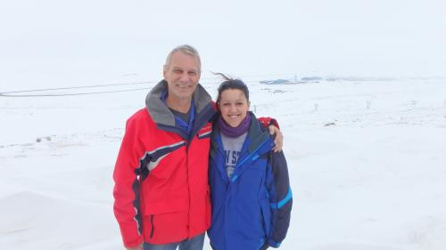 Teacher Kelly McCarthy with the late Dr. Piers Sellers.
| Attachment | Size |
|---|---|
| Download Report (1.27 MB)1.27 MB | 1.27 MB |
