Jakobshavn - One More Time
I have been asked a few times the following question: How do Greenland's glaciers differ from those in Alaska?
Thus far I've mentioned size and scale (Greenland has more and bigger glaciers, obviously) but another thing I've noted is the calving/sea ice interaction. The ocean-terminating glaciers calve a lot of ice into the water and they don't stop even in winter. But almost every one of these glaciers has MILES of iceberg packed sea ice extending out from it before you get to open water (with icebergs). I know that this happens more often in fjords (and Greenland has lot of those) because the water tends to be fresher (= freezes at a higher temp. than salt water) and the terrain of the fjord often shades the area from sunlight, keeping it colder as well. Here the fjords I've seen are relatively wide and so the shading isn't as pronounced as it is in the narrower, steep-walled fjords of AK. So that's another difference: the presence of of extensive sea ice choked with enormous icebergs (some as large as 1/4 mile square) extending several miles out from a glacier front.
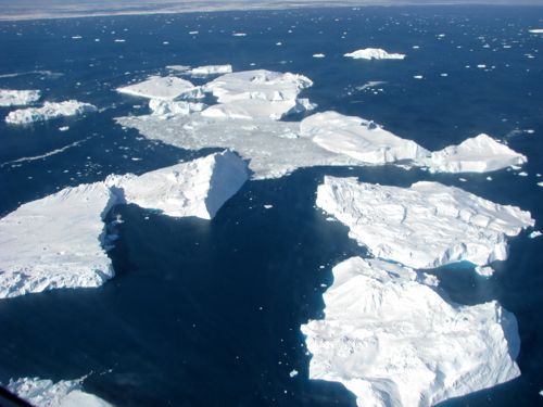 Huge icebergs from Jakobshavn Glacier float near the community of Ililussat.
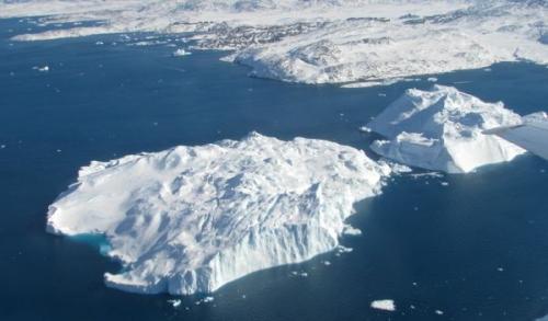 I love this photo as it gives a sense of scale. Just above the larger berg is the community of Ililussat. While Antarctica produces bergs WAY bigger than this, Greenland can calve some biggies. Just out of this photo were much bigger icebergs still.
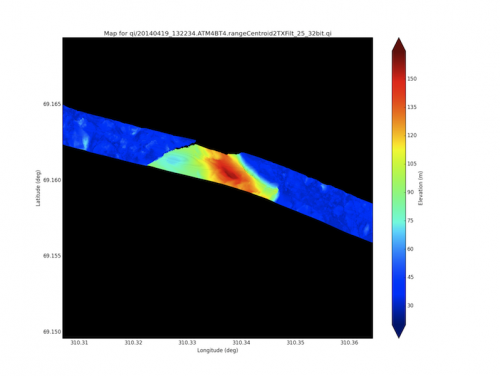 This is a colorized version of our laser (ATM) data as we flew over a Jakobshavn berg. The berg itself wasn't that big in area, but check out the vertical relief. This guy topped out at 420' above sea level!!!
We had a shorter flight today that once again took us north to the Jakobshavn Glacier area before heading further north still. The Jakobshavn Glacier is the most studied glacier in Greenland as it is the fastest moving, biggest glacier in the country. The small, quaintly picturesque community of Ilulissat sits near the mouth of the Jakobshavn Fjord. Nearly every building in this town glows with some shade of pastel coloring. In addition, the sea floor rises up just offshore so that many of the icebergs calved by the glacier hang up just offshore creating a very dynamic ocean view. (A quick Google image search of Ilulissat and you'll get an idea of what I am referring to.)
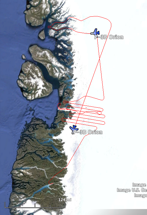 Our flight route for today.
Home Rule
Ilulissat used to be called Jakobshavn - the Danish name - before "Home Rule" was established. In 1979 Greenland, officially part of Denmark, was given control of most of its internal affairs. Denmark still retains control over the Greenland (particularly its foreign affairs) but most of the strings have been cut. About 60% of Greenland's GDP comes from Denamark and there is little doubt that, currently, Greenland could not survive on its own economically. Tourism, however, (to beautiful places like Ilulissat) has grown notably in recent years, though it remains an expensive ticket. But Greenland is carefully considering what to do about its abundant natural resources - rare earth metals and possibly off shore oil deposits. They appear to be pondering this potential with an appropriate amount of caution as the world is replete with examples of the "take the money and run" approach to resource development.
Greenland will likely gain full independence from Denmark down the road but they cannot financially survive on their own just yet. However the move towards independence is an inexorable one. Greenland is gradually assuming more governmental duties from Denmark. And since 1979 more and more places have dropped their Danish names and reverted to their Greenlandic origins (Jakobshavn has become Ilulissat and Sodrestrom is now Kangerlussuaq). In terms of pronunciation I think it's nearly a wash.
Which is easier for you: Pangnertupniaqornakavsa or Kangerterajitaigterterila.
Auvilikavsaupsarqardlia or Djaevelentommelfinger.
I can't do any of those.
Fjordland
The second portion of our flight took us to some of the most spectacular fjords of western Greenland. We dropped down from the ice cap, over the ice face, and cruised at 500' between steep walls extending 5000' above us. The entire fjord was still covered in ice (with relatively few icebergs in them), indeed as far as I could see the ocean was still covered in ice.
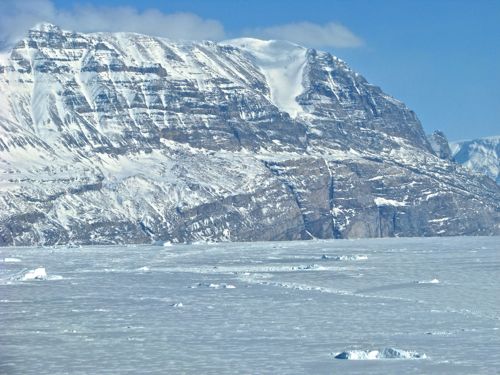 This mountain rises 3000-4000 above the fjord.
As we exited the first fjord I noticed sled tracks across the sea ice below. Following those it became obvious that a hunter was working the area. Alongside the tracks sat an empty sled, a small tent, and then the bullseye: the hunter himself skinning a just-harvested seal. The bloody snow draws the eye immediately to the scene. I didn't have time to shoot a picture but we may have caught it on our on of our four onboard cameras.
We circled the area completing a 240 degree turn and then headed up the next fjord. More jaw-dropping scenery: banded cliffs rising vertically above and, between mountains, small glaciers pouring almost like waterfalls down to the sea ice. I'll do what I can to get a copy of the dash mounted GoPro footage of this flight.
 We flew up this fjord at 500'. It was stunning.
Data Processing
As I finish writing this journal entry, the room next door contains three crew members crunching data on some high end computers the team brings with them. They are processing the radar data from our "low and slow" flight down the middle of the Jakobshavn Glacier. Though they have tried for years the OIB team has yet to get a good picture of the bedrock beneath the glacier. This is a critical piece of information for scientists modeling the glacier and its efflux. The reason this data has been elusive is that the tremendous crevassing and water-filled snow near the lower end of the glacier effectively blocks the radar signal preventing it from getting down to the bedrock. It looks like they're getting some usable data this time as I just popped in to check on things. The screen showed bedrock 1500 meters below sea level - that's a deep glacier as everything above that is glacier ice and it extends quite a ways above sea level. How's that for cutting edge science? That information is only minutes old!
Tomorrow is Easter Sunday - no flying but a huge group meal to look forward to. I'll help by baking an apple crisp for the team.


Comments