Closer Look: Arctic LTER
Toolik Field Station, North Slope, AK
June 19, 2019
Video of the Day:
Jason Dobkowski, a research scientist at Toolik Field Station in Alaska, explains how to sample dissolved gases in stream water. This sampling is conducted regularly throughout the field season as part of the NSF-funded Arctic Long Term Ecological Research Project (LTER). The main two dissolved gases present in Arctic streams are carbon dioxide and methane, which result from the breakdown of organic material leached from thawing permafrost soils. These are greenhouse gases, and they serve to amplify climate change.
Over the past couple of weeks, I have also been frequently assisting with data collection and analysis for the Arctic Long Term Ecological Research (LTER) project. This project was initiated at Toolik Field Station in 1987 with funding from the National Science Foundation, as part of their LTER Network. This network now consists of 26 sites in the US, Puerto Rico, and Antarctica.1
Research Goals
The research goals of any given LTER site specifically address the most critical questions for that location. In the Arctic, the main objective is to gather data to allow for better prediction of Arctic response to climate change and other disturbances. Research is themed around a core organizing question - how is the response of Arctic ecosystems to disturbances affected by openness and connectivity between terrestrial ecosystems, streams, and lakes?2
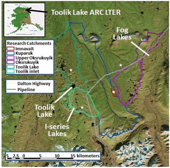 Arctic LTER study sites on the North Slope of Alaska. Image Source: Dr. George Kling (University of Michigan).
Arctic LTER Sub-Groups
Given the above core organizing question, Arctic LTER work conducted at Toolik Field Station is categorized into four main sub-groups - terrestrial ecosystems, streams, lakes, and landscape interactions.2 Dr. George Kling, with whom I am working, heads the landscape interactions sub-group; the remainder of this entry is focused on the work I’ve done with his lab.
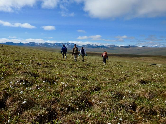 Jason Dobkowski, Dr. George Kling, Satya Kent, and Em Daily (left to right) walk to a study site near Imnavait Creek to take thaw depth measurements. North Slope, Alaska.
Landscape Interactions
The main goal of the landscape interactions sub-group is to assess how downstream ecosystems are affected by upstream/upland materials and species.2 Here’s an excellent summary figure provided by Dr. George Kling, illustrating how openness and connectivity of carbon and nitrogen from land to water lead to amplification of global warming:
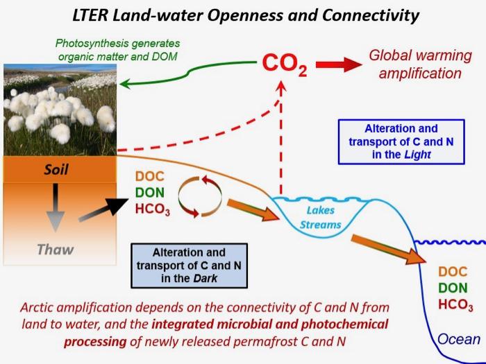 The openness and connectivity between land and water in the Arctic serves to amplify climate change. Image Source: Dr. George Kling (University of Michigan).
A large portion of the work of the landscape interactions team takes place on the inlet and outlet streams of Toolik Lake. On samples of this water, they conduct a very large battery of tests - pH, conductivity, discharge (flow rate), dissolved gases (see “Video of the Day” above), dissolved cations (e.g. iron, sodium, potassium, calcium), dissolved anions (e.g. chloride, sulfate, nitrate), particulates (carbon, nitrogen, and phosphorus), and chlorophyll. They even conduct photochemical analyses on samples, such as absorbance/fluorescence spectroscopy. On lakes in the area, the landscape interactions team collects light profile and dissolved gas data at multiple depths. There are 25 total water sample sites, and over 1000 samples are collected in a given field season.
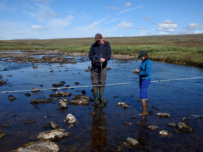 Jason Dobkowski and Em Daily measure discharge at the Toolik Lake outlet. Toolik Field Station, North Slope, Alaska.
In the below video clip, Jason Dobkowski elaborates on the operation of an ISCO unit, which automatically samples stream water at regular intervals for five days:
The group also evaluates groundwater flow by modeling how soil water flows through catchments, assesses the landscape distribution and dynamics of microbes, evaluates the chemistry of soil water in water tracks on the tundra slopes, and takes thaw depth measurements at various locations throughout the season.
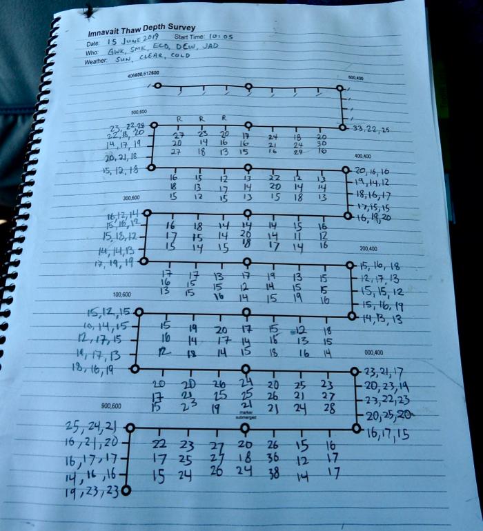 Study transect and data collection points for thaw depth measurements in the Imnavait Creek catchment. North Slope, Alaska.
Results
Data collection over the past 30 years has led the Arctic LTER landscape interactions team to many conclusions. Much of the data is publicly available, and here’s a list of most-recent publications. Three specific findings that really stick out to me, as related to climate change:
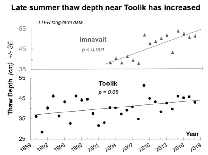 Arctic LTER data indicates that summer thaw depth has been increasing over the past 30 years near Toolik Field Station. Strong evidence suggests that this trend is due to climate warming. Image Source: Dr. George Kling (University of Michigan).
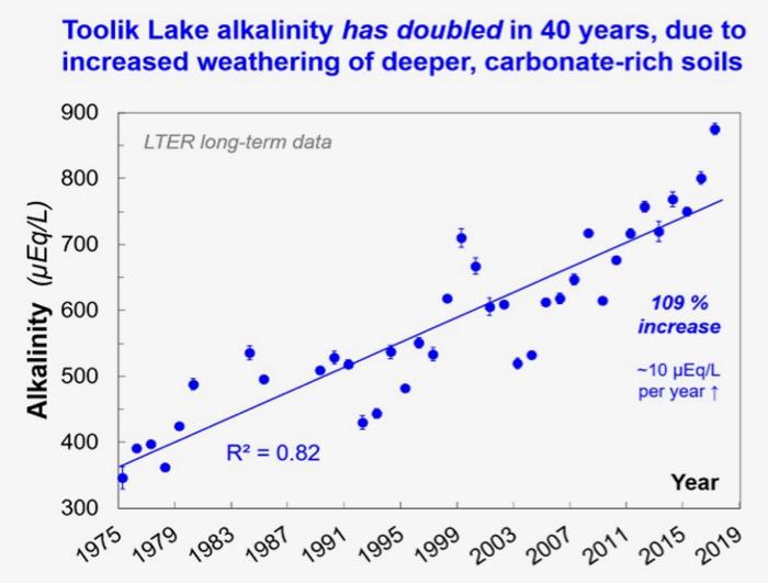 Arctic LTER data indicates that Toolik Lake alkalinity (capacity to neutralize acid) has more than doubled since 1975. Studies indicate this is due to increased thaw depth in the area (due to climate change, see above figure). Deeper thaw results in increased weathering of carbonates in catchments near the lake, resulting in higher lake alkalinity. Image Source: Dr. George Kling (University of Michigan)..
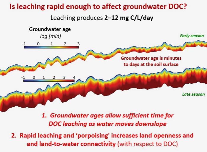 Flow modeling studies of water on tundra hillslopes indicates that there is enough time for significant leaching of organic carbon from the soil. Small scale topographic differences on the hillslopes (due to frost heaving) result in pressure differences that causes groundwater to "porpoise" as is proceeds downslope. This porpoising serves to increase leaching of organic material from the soil. Rapid leaching results in water with a high dissolved organic carbon (DOC) content. This DOC is broken down by sunlight and bacteria into carbon dioxide, which amplifies climate change in the Arctic. Image Source: Dr. George Kling (University of Michigan).
Comment below!


Comments
Add new comment