Update
Now Archived! PolarConnect event with Adeena Teres and John Woods from the Operation IceBridge Team on 24 April 2017. You can access this and other events on the PolarConnect Archives webpage.
What Are They Doing?
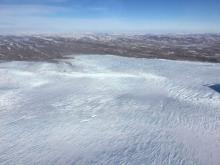
 Icebergs the size of a city block in eastern Greenland. Photo by Russell Hood.
IceBridge is in its 8th year as a NASA mission and is the largest airborne survey of Earth's polar ice ever conducted. IceBridge uses a highly specialized fleet of research aircraft and the most sophisticated science instruments ever assembled to characterize yearly changes in thickness of sea ice, glaciers, and ice sheets in the Arctic and Antarctic. The research team is experiencing first-hand the excitement of flying a large research aircraft over the Greenland Ice Sheet. While in the air they are recording data on the thickness, depth, and movement of ice features, resulting in an unprecedented three-dimensional view of ice sheets, ice shelves, and sea ice. Operation IceBridge began in 2009 to bridge the gap in data collection after NASA's ICESat satellite stopped functioning and when the ICESat-2 satellite becomes operational , making IceBridge critical for ensuring a continuous series of observations of polar ice. IceBridge flies over the Arctic and Antarctic every year - in the Arctic from March to May and the Antarctic in October and November. By comparing the year-to-year readings of ice thickness and movement both on land and on the sea, scientists can look at the behavior of the rapidly changing features of the polar ice and learn more about the trends that could affect sea-level rise and climate around the globe. Support for a teacher on this project is provided through separate funding to ARCUS through NASA. More information about IceBridge can be found at the NASA project website.
Where Are They?
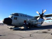
 NASA's P-3 Orion for Operation IceBridge. Photo by Russell Hood.
The field campaign for Operation IceBridge is based out of Kangerlussuaq in western Greenland, and Thule Air Force Base in northwest Greenland. Kangerlussuaq was once used as an American military base, the settlement is now Greenland's main air transport hub and the site of Greenland's largest commercial airport, and Thule is a fully operational U.S. Air Force Base, run by the Danish company Greenland Contractors. The climate in Kangerlussuaq and Thule is arctic, with temperatures ranging from -25 to 18 degrees Celsius throughout the year. Russell Glacier highlights some of the natural beauty that can be reached out of Kangerlussuaq, while Thule has lots of historical cold war Air Force sites included missile silos and ice field bases. The research team is living in the Kangerlussuaq International Science Support Building (KISS) and the Air Force Inn in Thule.
Latest Journals

John Woods is a native of Lavallette, NJ and currently resides in Annapolis, MD with his wife and 3 kids. He studied Oceanography at the United States Naval Academy and obtained his master’s degree in Oceanography and Meteorology at the Naval Postgraduate School in Monterey, CA. John served on active duty in the U.S. Navy as a Surface Warfare Officer on the USS Cleveland (LPD-7) deploying to the Persian Gulf two times, and as a Meteorology and Oceanography (METOC) Officer at the U.S. Naval Ice Center. His final tour was back at the U.S. Naval Academy teaching in the Oceanography Department where he created the Polar Science Program. This assignment first introduced him to Polar Operations and Logistics leading 4 different learning activities to the Arctic Region. After transitioning to the Navy Reserves, he was the Project Manager for NASA's Operation IceBridge, successfully executing over a dozen science campaigns to both the Polar North and South. Most recently John was a physical scientist for NOAA at the U.S. National Ice Center until recently transitioning back to the Navy in his current position with the Office of Naval Research, International Engagement Office focusing on collaborations with polar nations.


