Today we flew over Northwest Greenland. In this area the ice is ending in the sea. Being my first flight in the P-3 Orion, I was very excited. Taking off was easy and once we were in the air I was elated. I was told this was going to be an easy day and it was in the aspect of taking measurements. The turbulence was another story. Right after take off and right before we landed it got bumpy. It wasn't horrible, I've been through worse but it made getting up and taking pictures difficult. It is hard to take a nice picture when you're bouncing up and down. I wasn't shaking the camera, but the plane was shaking me. Holding my camera steady became an impossible task. For most of the flight it was smooth and I got some good pictures of the ice.
Today's mission was flying flux lines. The plane has flown these lines on past missions and the scientists use this data to make comparisons to years past showing how the ice has changed over time. By showing how the ice has changed, scientists can see how the ice is moving. The two main things that we measured today was the height of the ice and its depth. To accomplish this the Airborne Topographic Imager or ATM was used. This is a laser altimeter that uses light to measure the height of the ice. The ATM bounces a laser off the surface of the Earth and measures how long it takes that signal to get back to the plane. Scientists can tell the elevation of the ice by using this data and by knowing the position of the airplane. Another piece of important data from today's flight is the depth of the ice. This can be found by using data collected from the Multi-Channel Coherent Radar Depth Sounder, MCoRDS.
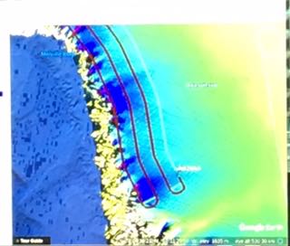
The flux lines work like a cattle gate. If a rancher wants to count his cattle he will pass the herd through a gate. As the cows pass through the gate the rancher can count them. Flying the flux lines is the same general idea. We are flying four lines. It's like mowing your lawn. The plane flies down in one direction then it flies the next line in the opposite direction. As the ice passes through these four 'gates' the scientists can measure how much ice is passing by each of the gates.
 This is the flight plan from the IceBridge flight on April 12 2017. These lines are called flux lines and the plane flies up and down the lines, just like mowing a lawn.
 Flight plan of the P-3 from Operation IceBridge on April 12 2017 as it progresses along the flight lines.
I am also posting a video from yesterday's hike to the ice cap. In the video I talk about the glacial moraines. Moraines form as the glacier scrapes and breaks off pieces of the rock underneath as it passes over. Glaciers form on land, and are affected by temperature, precipitation, and cloud cover. Glaciers are sensitive to environmental conditions. By looking at the mass of glaciers over time scientists can use the data to get an indication of climate change. The coast we flew over in the plane today also has many glaciers that flow down from the vast ice sheet that covers the interior of Greenland.


Comments
Add new comment