Update

Now archived! PolarConnect event with Maggie Kane from Punta Arenas, Chile and Project Manager John Woods from Antarctica. You can access this and other events on the PolarConnect Archives site: https://www.polartrec.com/polar-connect/archive

What Are They Doing?

NASA's P-3 Orion aircraft. Photo by Mark Buesing.NASA's P-3 Orion aircraft. Photo by Mark Buesing.

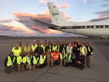
IceBridge, a six-year NASA mission, is the largest airborne survey of Earth's polar ice ever conducted. IceBridge uses a highly specialized fleet of research aircraft and the most sophisticated science instruments ever assembled to characterize yearly changes in thickness of sea ice, glaciers, and ice sheets in the Arctic and Antarctic. The research team will experience first-hand the excitement of flying a large research aircraft over the Greenland Ice Sheet. While in the air they will record data on the thickness, depth, and movement of ice features, resulting in an unprecedented three-dimensional view of ice sheets, ice shelves, and sea ice. Operation IceBridge began in 2009 to bridge the gap in data collection after NASA's ICESat satellite stopped functioning and when the ICESat-2 satellite becomes operational in 2016, making IceBridge critical for ensuring a continuous series of observations of polar ice. IceBridge flies over the Arctic and Antarctic every year — in the Arctic from March to May and the Antarctic in October and November. By comparing the year-to-year readings of ice thickness and movement both on land and on the sea, scientists can look at the behavior of the rapidly changing features of the polar ice and learn more about the trends that could affect sea-level rise and climate around the globe. More information about IceBridge can be found at the NASA project website. http://www.nasa.gov/icebridge

Where Are They?

Punta Arenas, Chile. Photo by Amber Lancaster.Punta Arenas, Chile. Photo by Amber Lancaster.

Punta Arenas is a city near the tip of Chile's southernmost Patagonia region. Located on the Strait of Magellan, which connects the Atlantic and Pacific oceans, it's often used as base for excursions to the surrounding wilderness and Antarctica. The Plaza Muñoz Gamero has a memorial to explorer Ferdinand Magellan, and the Museo Nao Victoria features a replica of one of his galleons. The research team will be based out of a local hotel in downtown Punta Arenas, and the plane will be based out of the International Airport.

Latest Journals

Santiago Talks After such wonderful field work airborne over Antarctica with the team, I had loads to share with students and teachers, and fortunately I had several talks set up. After saying "ciao" to the windy Straits of Magellan and Punta Arenas, I headed to the hot, smoggy, bustling and…
Nearing The End Nearing the end of my time with the NASA team made me want to spend as much time in flight as I possibly could, so lucky for me, we had a few flights ahead of us and good weather forecasted. With only a few high priority flights left on the list, the team was feeling really proud…
Ice Shelves vs. Ice Sheets vs. Ice Tongue vs. Marine Ice Ice shelves are found in polar regions, at the edges of ice sheets. They occur as land based ice sheets meet the ocean waters and float out away from the land. It might be hard to imagine such massive objects floating, but like any ice,…
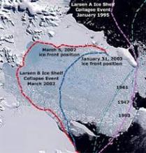
Calving of the Larsen Ice Shelf The Larsen Sea The Larson Sea is the site of the calving event 15 years ago that broke off the Larsen B ice shelf, sending it towards its demise to the north. This event got a lot of news coverage so you might remember seeing an image of it. Now, the area is a…
Dates
-
Location
Punta Arenas, Chile and airborne over Antarctica
Project Funded Title
NASA Operation IceBridge
Maggie Kane - Teacher
Teacher
Rocky Mountain School of Expeditionary Learning

Maggie Kane is fascinated by snow and ice, studying climate science since 1985 when she ventured to Baffin Island to study the chronology of debris flow events. Graduating from Hampshire College with a degree in geology, and earning teaching credentials from Prescott College, Maggie started 15 years of teaching middle school Earth and space science. Maggie joined the TREC program studying climate change in Svalbard in 2006, and received her MS from Montana State University in 2010. Maggie chose to become an instructional coach and academic dean at high elevation Lake County High School in Leadville, CO where she works with teachers and students in the 7th and 8th grades developing strong instructional practices as a new Expeditionary Learning school. A NOAA Climate Steward and enthusiastic collaborator with polar scientists, Maggie has won numerous local and regional awards as well as placing 3rd in the national Thomas Edison Award for Innovation in the Science Classroom.

John Woods - Researcher
Researcher
Office of Naval Research Global

John Woods is a native of Lavallette, NJ and currently resides in Annapolis, MD with his wife and 3 kids. He studied Oceanography at the United States Naval Academy and obtained his master’s degree in Oceanography and Meteorology at the Naval Postgraduate School in Monterey, CA. John served on active duty in the U.S. Navy as a Surface Warfare Officer on the USS Cleveland (LPD-7) deploying to the Persian Gulf two times, and as a Meteorology and Oceanography (METOC) Officer at the U.S. Naval Ice Center. His final tour was back at the U.S. Naval Academy teaching in the Oceanography Department where he created the Polar Science Program. This assignment first introduced him to Polar Operations and Logistics leading 4 different learning activities to the Arctic Region. After transitioning to the Navy Reserves, he was the Project Manager for NASA's Operation IceBridge, successfully executing over a dozen science campaigns to both the Polar North and South. Most recently John was a physical scientist for NOAA at the U.S. National Ice Center until recently transitioning back to the Navy in his current position with the Office of Naval Research, International Engagement Office focusing on collaborations with polar nations.

Operation IceBridge Antarctica Resources

Overview

This lesson allows students to consider navigation around Antarctica, where longitudinal lines converge at South Pole. Through this study, students should learn about polar stereographic projection, satellites, navigation using various instruments, Antarctic geography, and NASA’s Operation IceBridge airborne mission. In the first part of this 55-80 minute lesson, students will be faced with a dilemma. Their task will be

Lesson
Antarctic
About 1 period
Middle School and Up
Download and Share

Overview

NASA’s Operation IceBridge (OIB) flies airborne missions each year over both Polar Regions, collecting ice thickness and extent data on glaciers, ice caps, ice shelves and sea ice. This data is useful to many disciplines studying climate, weather, ocean circulation, sea level and many related fields. The National Snow and Ice Data Center (NSIDC) houses and organizes the data

Lesson
Antarctic
Less than a week
Middle School and Up
Download and Share

The Revitalizing Power of Teacher-Researcher Collaboration

The nature of science is continually moving us forward; from a fresh set of findings we rush ahead excitedly to the next batch of questions. From this continual pursuit, new ideas, methods and instruments are designed by scientists and technicians at a rapid pace, in turn yielding new data. As science teachers, we need

Report
Antarctic
Download and Share

Copy of online article from NASA Goddard Space Flight Center on Operation IceBridge. NASA’s airborne survey of changes in polar ice, is closing in on the end of its eighth consecutive Antarctic deployment, and will likely tie its 2012 campaign record for the most research flights carried out during a single Antarctic season. Maggie Kane and PolarTREC are both mentioned

Article
Antarctic

Englewood Herald article describing teacher Maggie Kane's work with NASA's Operation IceBridge Antarctica program.

Article
Antarctic

Teacher Maggie Kane discusses the research involved in the NASA campaign Operation IceBridge Antarctica.