Journal Entry

Hull Glacier-2 and the Getz Ice Sheet

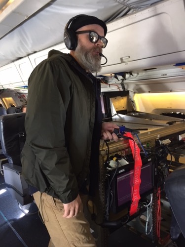
What is inside the plane is just as amazing as what is outside the plane. The phrase NASA uses is “the most sophisticated suite of instruments ever assembled”. The scientists and engineers working onboard are just as impressive as the landscape and instruments themselves. What most people don’t realize about this kind of work, is that the scientists are all working on different projects that are interrelated, and are onboard because of the access to the ice through Operation IceBridge flights. Not surprisingly, the “teams” tend to stick together socially as well, as they come from the same home institutions, such as Lamont Doherty, University of Kansas, University of Colorado, and University of Maryland. The cross over and gap-filling that each instrument does for the others is really interesting.
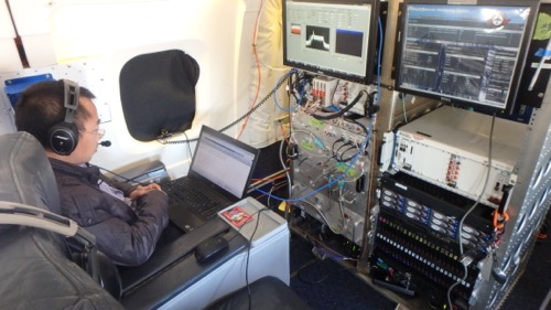
instrtmsScientists sit with their instruments throughout the long flights.

Sea Ice Discussion

Newly arrived and on board today is NASA’s Alec Petty. He is a Post Doctorate fellow at the University of Maryland, studying sea ice to learn how the texture of the ice, including roughness, ridges and keels, influences ice floe thickness and movement. His work focused on the Arctic gyre and sea ice thickness in both polar regions.
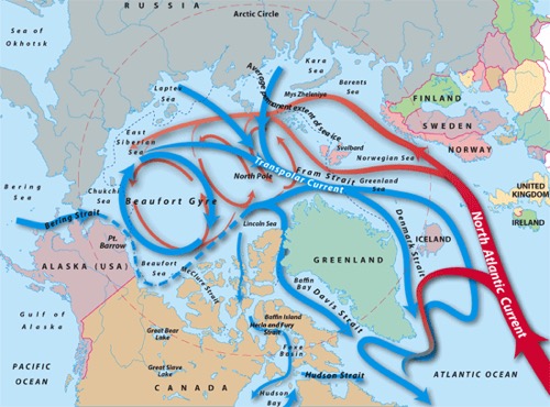
arctgyreThe Arctic Ocean gyre circulates the water in the northern polar region. It is quite different around Antarctica.

Old ice used to be the thickest, as new snow accumulated on top of old, the mass increases each year. Now, the older sea ice is the thinnest. He is curious to see whether that is true in Antarctica as well, but cautions that the complexity is much higher here than in the north. This may be caused by ice floe flooding as the floes become heavy with snow, which might cause them to become low and tippy, and covered in sea water. Modeling what may be happening is made extremely difficult by the possible complexities.
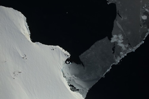
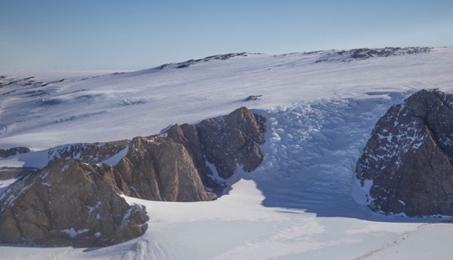
seaice6The complexities of sea ice are fascinating. Hull GlacierThe Hull Glacier is interrupted by mountains, making for an exciting low altitude flight
Curious about changes to ice floe salinity over time, we discussed how the salt in freshly made ice (one year ice) contains about 10 ppt of salt to water, and as time passes, the salt drains down through the ice through gravity and percolation of melt water. After 2-3 years, the ice contains as little as 2-3 ppt salt.

Preflight Preparation

The pilots, scientists, and instrument teams all have work to do before the flight. Checking the weather is top priority because it will determine which campaign we choose for the day. Reading weather imagery is done by the pilots, navigator, engineer, and project scientists, as well as airport personnel. Understanding how to forecast weather is a central skill to this mission, as the instruments need clear skies to collect data. Flying 4 hours to a cloud target site would be a huge waste of resources, so choosing the correct location for work is their first order of business. A pre-flight briefing is held at 0900 hours to confirm flight manifest, weather conditions, length of flight, fuel load, etc. Then we board the aircraft and get set up. For the scientists, they will go through their instrument calibration after electrical transfer is made from the ground to the plane.
TrevTrevor Traynor assists Dr. David Gallaher start the Mini-Rad

Wildlife - Lookout Below!

The OIB team works really hard NOT to see wildlife. Sorry if that is disappointing! The Antarctic Treaty ensured that scientific endeavors on or above Antarctica would not disturb the wildlife, and NASA does a remarkable job upholding that expectation. When an area has been mapped as significant, the flight plans need to go at least 1 km away from them – OIB makes sure to go at least 2km away.
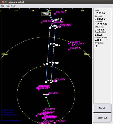
wildlfThe pink locations are colonies that we avoid. Flight plans can be altered because of penguins, seals, and birds. radarA peek at the hidden topography of the bedrock below the ice.
Comments

Guest

Ah yes, the fathoming for data is done by a variety of different instruments to gather a clear sense of the shape below. Sometimes in the cirques on the side of mountains, the ice fills a bowl shape which is neat. Thanks for you comment!

Zach

Was it ever to cold to go on the plane? Did any of the technology stop working because of the cold temperature?

Maggie Kane

Hi Mina, sorry for the delay! I never pasted my answer in - here it is:YES! Scientists spend a LOT of their time collaborating and discussing their research with each other. In fact, before they can get published, they go through a very rigorous peer review process that asks other professional scientists to carefully read and possibly rips their papers apart, and may result in not being published at all! This process ensures that bias, poor experimental design or wonky conclusions do NOT become part of the field of published science. This is really what separates science from just regular review, where opinions run the show. Scientists use each others data and share what they find too – the questions about the natural world are so complex, and to study anything deeply enough to make progress, most scientists have very narrow fields. They need each other!

Maggie Kane

Hi Sophie and Jordan,My work with this project has a few different angles. One is to learn and share with my own students and community. I've done more of this with 9-10 since we were studying climate science this fall, but also reached you all through our webinar. I also share and give talks to others outside of school. So far I've reached over 900 people with talks, and I'll give a lot more this winter/spring in Colorado so that allows the project to be "spread" through my presentations. This helps the NASA team to get the word out about their work and inform the American people. I am also really involved with "chats" that we have directly on the plane with classrooms. No one at RMSEL took advantage of this tool, but many classrooms around the country have, including quite a few colleagues of mine at their schools in RI, WY, NY, AZ etc. Its really fun for schools to write questions and read answers in real time with the scientists - some even got a satellite call from our navigator Walter which was super cool for them. It is also really important for teachers to continue to learn for their own professional growth, and this experience is a kind of professional development. Teaching is very challenging work, and we need to stay inspired and lively as learners. The idea with PolarTREC is that it pairs researchers with teachers as a win-win relationship, allowing the science to come to life beyond the academic world of scientists. Pretty cool! SInce I love the polar regions and specifically love ice and the story it tells us, this project was a great choice for me. Thanks for your question!

Maggie Kane

Hi! Fun question! I asked around and didn't get much input on the alien question, but there is definitely life below the ice in water. Lake Vostok is one area where that has been discovered. The Russians drilled down into it, and unfortunately contaminated the lake with the drill chemicals. To access the water to study the life will be very tricky as we don't want to further contaminate it. This would be a good topic to look up and learn more about!

Maggie Kane

Hi Dakota, I never pasted this answer in - sorry for the delay! The most interesting piece of equipment on board has to be the gravimeter. Oh wait, maybe the green laser that reads the surface topography… or the radars that work on a low frequency and penetrate the ice all the way down to the bedrock… or maybe it’s the plane itself that holds all the different equipment. I’ll tell you a little about the gravimeter though. it is basically a gyroscope inside a round can that is so sensitive to the pull of gravity that it can record how massive the Earth is directly below it. It can tell the difference between water, ice, rock, air etc., so it can map the bedrock surface! Its amazing, oh yeah, and super pricey!

Maggie Kane

Hi Natalia! Sorry, I never pasted my answer in - here it is. We need to avoid wildlife so we don't bother it. As part of the Antarctic Treaty, the world decided to set aside Antarctica for scientific study, and to cause as little impact as possible. Part of this will be how we treat the life there, so we try not to impact it much at all. Your other question about the plane is a good one too - we have enough space to work and stretch out a bit. People to push-ups on the hour and just find a place with enough space and drop and do 25! The seats are comfortable and roomy too. We have a little kitchen at the back of the plane for warming up food we bring, or grabbing coffee. It is plenty big for all of us! Thanks for your question!

Maggie Kane

Hi Hannah,Sorry I guess I missed this question! Bad weather is something we tend to avoid because the instruments can't "see" through the clouds. We also need to stay safe so we don't take off or land when there are very strong winds in Punta Arenas where we are based. We choose where to study each morning based on the wether data from two or three satellites. John Sonntag is able to read the data and make really accurate forecasts about what it will be like in each of the possible study areas, and then makes a recommendation about which will be the best area to go to that day. It is a big responsibility and he does it extremely well! Imagine if we flew all the way to someplace and found it story - that would be bad! Everyone's time is very limited and each flight costs $20,000 or more to undertake, so the data is precious. Everywhere we went to, we found a beautiful clear day, with blue skies! A few times there was some fog and we had to scoot underneath it. We fly very low (1,200 - 1,500') so unless it is too low, we manage to get below it. Only a few times did we miss some data because of something like this. We had turbulence a few times but it was interesting that I got really used to it quickly and I didn't feel scared at all. I really like to fly, so it was always fun to be onboard!

Maggie Kane

Hi Zach, excellent question! We had a few moments where things didn't work because of the cold. Both the coffee maker and one instrument, the ATM, stopped working because they got too cold. The ATM was fixed with a great team effort overnight, but the coffee maker was a casualty that proved pretty difficult for the whole plane! South Pole is very cold (-60* F) so when we crossed that on our two flights, the plane got really cold. We stayed relatively warm inside, but usually wore coats and hats and layers of clothing. The front of the plane (cockpit) was warmest, so sometimes they got hot and needed to turn the heat down, but then the back of the plane got cold. I also had a blanky I threw over myself sometimes when I took a nap - that helped! Thanks for your question!

Guest

Why aren't you allowed to disturb the wildlife? Any specific reason?

10th Grade Class

Congratulations! This is really interesting. I hope everyone has a great time. Maggie, have you experienced any extreme weather? And Connor wants to know if you got to sit in the Jump Seat.Let us know,
10th grade class.

Maggie Kane

Hi 10th grade! So great to hear from you guys!
So far, the only extreme weather was today, so we couldn't fly. The crosswinds were forecast up to 45 knots, and the airport is small, so there is only one runway. The winds would have been across us, and that is not safe, so we had a down day :( I have been flying a lot and that has been amazing. The weather work the NASA team does with the airport people is super impressive. I'm learning SO much and it is so amazing to see so many parts of Antarctica. I can't even begin to realize how much ice there is here!
I DID get to sit in the jump seat my very first landing last week! It was so incredible! I hope to get to take off sometime too. Everyone is really nice and easy to talk to and learn from. I hope you all tune in for the webinar tomorrow and ask lots of questions!
Send more comments! It makes me feel closer to home :)
Maggie

Maggie Kane

Great question about wildlife. Well, back in 1959, a dozen countries wrote up the Antarctic Treaty that went into effect a few years later. The main purpose of this was to ensure that "in the interest of all mankind that Antarctica shall continue for ever to be used exclusively for peaceful purposes and shall not become the scene or object of international discord." With that in mind, stewardship and care needs to be taken to leave the continent for science and as a natural place to study our world. Mapping where the colonies are on the maps allows scientists to avoid them. The protection of animals was signed by congress years ago, so if we disturbed them in a known area, it would be a federal offense. There is also a large area of "clean air space" that we need to avoid. Its pretty cool to think that the entire continent is protected!

Whole 9th Grad…

Hey Maggie did you guys celebrate Halloween, also what are the common extreme weather patterns.

Janet A

You said that "the scientists are all working on different projects that are interrelated". What is your part of the project that you are working on?

Maggie Kane

Hey 9th grade! Great to hear from you! I hope you are all doing well! So, I had a whole bag of Halloween things to put on and share, but the NASA crew was pretty focused on their work and no one dressed up. Its ok because we were in jackets and hats anyway, but it would have been fun to do something all together, like all be zombies or something. The pilots and mission folks wear tan flight suits, like astronauts, so they joked that they were dressed up as astronauts.
Antarctica has really different weather than we do up in the US. It swirls around and comes from different directions and can have really powerful storms. There is little moisture in the air because the air is SO cold (it can't hold much moisture) so if there is any moisture, it will drop out quickly. We try to avoid any moisture because the instruments need clear skies to record data. I am going to pass your question to John Sonntag though - he is our meteorologist/scientist extraordinaire on the the team. He is pretty good at communicating fast, so I hope to have more info. for you soon! Thanks for the question!
Maggie

Jace C

What is the most interesting thing you've learned so far?

Ben S

What are some of the instruments used and what are they used for?

Maggie Kane

Hey 9th grade!So here is what the amazing John Sonntag shared with me last night. I want to learn more about these types of storms too.

John Sonntag: A favorite of mine is the katabatic (aka "gravity") wind. The Antarctic continent itself creates katabatic winds. What happens is this: Antarctica is a basically a colossal mountain of ice, more than two miles tall and thousands of miles across. The lower atmosphere which comes into contact with this giant dome of ice gets cold because of it, and when it gets cold it also gets dense. When it gets dense it starts sinking because it is heavier than the surrounding air. It can only sink in a downhill direction, of course. But because Antarctica is so big, it sinks gradually and over a long distance, picking up speed the whole time. In other words, the air mass flows downhill under its own weight. When it reaches the coast of Antarctica, at sea level, it can blow as hard as 200 miles per hour, although 60-80 mph is more common. It also warms up as it flows downhill - it has to, because its pressure increases as its altitude decreases. Thus, a katabatic windstorm, a very common event on the coasts of Antarctica, is also a relatively warm event. Temperatures can rise more than 20 degrees in a few minutes, at the onset of a katabatic wind event.

By the way, the same thing happens in Greenland, and for the same reason. One consequence of this is that both Greenland and Antarctica have semi-permanent high-pressure weather systems over their plateaus near their geographical centers. High-pressure air is also sinking air, and thus very stable and very, very dry. This means that the polar plateaus are basically deserts with very little snowfall. This is incredibly ironic, when you consider that the plateaus are themselves *made* from snowfall. This demonstrates how ancient these ice sheets are, because it takes a very long time to build a gigantic two-mile high mountain of solid ice from snow, when it doesn't snow much.

The "polar vortex" is a related phenomenon, which occurs not at the surface of the earth but at mid-altitudes. This happens because of the high-pressure, and sinking air, at the surface. The sinking air creates a vacuum at higher altitudes, and nature, as we know, abhors a vacuum. So the vacuum is filled by air from higher altitudes, creating a low-pressure area there. This in turn sucks in more air from around the Poles. But the Coriolis Effect causes this inrushing air to spin (clockwise in the Antarctic, counterclockwise in the Arctic), and that huge spinning air mass is the polar vortex

Maggie Kane

Hi Jace,well, that's a tough one! I am in an amazing situation, surrounded by incredible scientists and aeronautic experts, intricate and never-before-designed instruments, and the strangest landscape on Earth. I am loving learning about the system of scientific research as a broad topic, because it is quite different than most of us expect. Instead of assembling a team to go out and answer one set of questions, this team is assembled from many places, and includes many instruments that are all together because of access to the location. There are no other American planes that fly in this area like the DC-8. This is the only way to gather high resolution, close to the ground data. And it only occurs once per year. If you are a sea ice scientist, you want to get on board this plane, and gather data! There is an overarching question that weaves everyone together for sure: what are the characteristics of the ice over Antarctica, and how are these characteristics changing year to year. NASA runs the mission, but the scientists and their instruments are somewhat separate from NASA, so some people work directly for NASA, and some work for their home institution. Many are Post Doctoral Fellows, people who received their PhD recently and are working with a University. Some are research scientists who work for a University but don't teach a single class. Some are the engineers that designed and built the instruments. Its really interesting! But this is a group of scientists who are responsible for collecting the data that the world needs to understand what is happening with sea level - THIS GROUP! Its so amazing to be a part of it. But... back to your main question - there are so many things to learn every day, its too hard to pick! I am working on a journal post about the Min-Rad, a small 2 lb instrument designed and build at CU Boulder that collects microwave data. Its really fascinating! Stay tuned!

Maggie Kane

Hi Janet,Great question! As a geologist who has studied the polar regions since the early 1980's (I know, I AM that old!) and an educator, I have a special role here with Operation IceBridge. I get to learn, and share. While I have a good background in this area, I am not at all an expert (not even close!) but I get to learn with and from the experts. This not only helps me grow as a scientist/teacher, but also gives me a big responsibility to share. My grandmother taught me that it is wonderful to love a topic, or be good at a skill, but you can't just hold it to yourself - you have to share it with the world. She was so right! My job is to share what this amazing group of scientists are doing and learning. I have some really cool opportunities to do this here in Punta Arenas (I am giving talks at The University of Magellan and in a few classrooms here in this town in Chile where we are based), in Santiago at a University on my way back, to classrooms in the US through chats on the plane using xchat (a program through NASA), through my journal and social media, and though the webinar I will have today. This group of scientists and these instruments are breaking ground and are telling the story of ice on our planet like never before. It is seriously the real deal! When you hear anything about Antarctica, ice, wea level, changes... it is likely that OIB data is part of that story. I get to share their story and bring it back to you guys as best I can. Keep watching and reading as I learn more!
Maggie

Maggie Kane

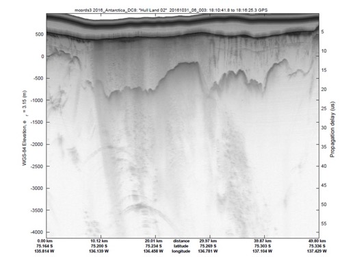
Hi Ben! Thanks for a great question.Honestly, this area is one of the most fascinating parts of the project for me. I am still learning what the instruments do, but I can share what I know so far. One of the main instruments is the the ATM (Airborne Topographic Mapper) that "reads" the surface of the ice. This gives us a very accurate map of the elevation and texture of the surface). When that is paired with the Radar, that reads through the ice down to bedrock (think of the power of this!), we see what the entire ice sheet is like inside. This can give scientists a really good idea of the mass of the ice, which we need to know to make any kind of prediction about sea level rise. On this journal post, I put a picture that shows what the radar can show us, with the cross section of the ice. If you think back to Peter Neff's talk, you can see how this would be useful to someone who wants to do ice coring and pull samples. We also have a Gravimeter that is able to pick up very subtle differences in the pull of gravity below the plane. This means that it can tell the difference between ice, water, bedrock! So, if there is a huge mountain under the ice, the gravimeter can tell that by a stronger pull. We also have an instrument called the Mini-Rad, what collects data on microwaves. I am still learning about microwaves, but this small 2 lb instrument will be attached to a satellite in a few years, so Dr. Gallaher is testing it out on this flight. He and his Graduate students at CU Boulder designed and built this little instrument - pretty cool stuff! There is also a digital mapping system (DMS) that takes very high resolution photographs that are paired with GPS so we know exactly where they were taken. Most of the instruments are housed in the forward or aft pit, where a commercial airliner would keep the bags. It is very cold down there. The other day, crossing South Pole, it was -70* down there - ouch! Some instruments are up with us - the gravimeter is right behind the seat I usually sit in, and looks like R2D2. I'll put some more pictures in my next journal. Thanks for a great question!
Maggie

Mya Maliyevsky

Hello Maggie, hope you are having a wonderful time. I was wondering what is your role in this team? Which of the tools do you get to work with? Thank you. Keep having fun!

Mya Maliyevsky

Hello Maggie, hope you are having a wonderful time. I was wondering what is your role in this team? Which of the tools do you get to work with? Thank you. Keep having fun!

Mya Maliyevsky

Hello Maggie, hope you are having a wonderful time. I was wondering what is your role in this team? Which of the tools do you get to work with? Thank you. Keep having fun!

Mya M.

Hello Maggie, hope you are having a wonderful time. I was wondering what is your role in this team? Which of the tools do you get to work with? Thank you. Keep having fun!

Mya M.

Hello Maggie, hope you are having a wonderful time. I was wondering what is your role in this team? Which of the tools do you get to work with? Thank you. Keep having fun!

Mya M.

Hello Maggie, hope you are having a wonderful time. I was wondering what is your role in this team? Which of the tools do you get to work with? Thank you. Keep having fun!

Mya M.

Hello Maggie, hope you are having a wonderful time. I was wondering what is your role in this team? Which of the tools do you get to work with? Thank you. Keep having fun!

Mya M.

HeHello Maggie, hope you are having a wonderful time. Which of the tools do you get to work with? What data are you receiving currently? What can you tell us about the climate change right now? Thank you. Keep having fun!

Mya M.

HeHello Maggie, hope you are having a wonderful time. Which of the tools do you get to work with? What data are you receiving currently? What can you tell us about the climate change right now? Thank you. Keep having fun!

Mya M.

HeHello Maggie, hope you are having a wonderful time. Which of the tools do you get to work with? What data are you receiving currently? What can you tell us about the climate change right now? Thank you. Keep having fun!

Delaney Seaton

What do all of the different projects have to do with each others?

Sophie Brainar…

Hi Maggie, we hope you are having fun in Antarctica. Jordan and I are wondering what specific tools do you use and what is your specific job on the plane?

Guest

What are your (scientists) thoughts/beliefs on aliens or other life in the universe. Also, do you think there could be life under the ice? (i.e. underground lakes)

Guest

Are there any snakes there???? -ian

Mina H

Hey Maggie! Hope you're having a good time & representing thee crew! I also have a question about the interrelated-ness of the projects of the scientists you're with. Do you guys compare projects & results? And do you ever end up having really interesting finds that don't relate to your project but are super important for another scientist's?

Dakota O

Hey Maggie, Hope you are haveing an amazing time in Antarctica, it's so awsome how you get this opportunity. I was wondering, what is the most intresting piece of equipment that you have on board the plane?
Hope Have a safe and great trip
-Dakota

Maggie Kane

Hi Mya, so happy to “see” you online! My role here as a science teacher is to learn, and to share. We science teachers constantly have to grow and learn new things to stay up to date in our fields, and to stay excited about teaching. Also, we are good at explaining (or I hope we are) to people outside of the high academic science world, so we can be really useful to the scientists and their program. Scientists get grants to do their research, and often their grants require outreach, or some form of sharing of their data to the real world, outside of academia, so regular people can understand. This is where teachers come in! For instance, I am at this moment, chatting with schools (36 students right now) about the mission. The scientists are also discussing things, but I get to help. Last weekend I have gave a talk to high school students from Punta Arenas, Chile who are in an honors program to learn English and try to get to university in United States. I have another talk planned for Monday evening, for 100+ students here from middle through high school grades, and I will lead them on a tour of the plane on the next “down day” we have when the plane is at the airport, not flying. I will present at the American Embassy school in Santiago on my way home, AND most importantly (in a way) I get to share all this with you guys back at RMSEL! It is exciting work, and it is so cool that students get to see it happen to their own teacher, and follow along.
As far as climate change goes, I can tell you that the measurements onboard tell a pretty interesting story. Many parts of Antarctica are experiencing rapid ice thinning, like the glacier we are heading to today as I type this. Some areas are seeing more sea ice out past the ice shelves, which might be caused by a shift in the wind patterns or a more rapid departure from the land due to less friction under the glacier because of a slightly melted base…but they don’t really know! The teams here are observing a lot of recent change, for sure, and are busy collecting data and designing the next instruments to learn more.

Natalia

Hey Maggie, It's Natalia hope you're having fun. I had to add my comment on someone else cause I can't make my own for some reason. Any I read that you can't see and have avoid from seeing any animal life why is that? And also you have all this equipment in the plane is the plane huge but you don't have that much room for your self or is it bug enough for all the equipment and enough room for you like a normal plane?

R. Kane

Maggie,Your journals and the chat the other day are so interesting - you're really 'fathoming the bowl' on this adventure. Love,Rach

Hannah

Hi Maggie,
Hope you are having such an amazing time! I was wondering what kind of weather you have seen so far?

Thanks,
Hannah

Maggie Kane

Hi Delany! Thanks for your question! All the projects are interconnected through studying the same ice transects year after year. The flight paths were designed specifically to get the instruments over areas that are changing rapidly or are representative of the continent. For example, yesterday we flew over Thwaites Glacier in western Antarctica, which is considered one of, if not THE most important glacier in the world when studying speed of melt and affect on sea level rise. This glacier is moving fast (2km per year) and is calving (loosing icebergs) into the Amundsen Sea. The instruments on board took their first “baseline” flight over this glacier to get a detailed profile of its structure. Through an ATM (Airborne Topographic Mapper) we can learn about the surface of the ice, through a “snow light penetrating radar” we can learn about the top 20 m of snow and young ice, through a deeply penetrating radar we can learn about the ice down to 200+m and through the gravimeter, we learn about the bedrock below. Additionally, we have very accurate digital mapping systems and precise GPS systems that all the instruments use. All these instruments, in combination, tell the story from surface to rock and can help us understand the characteristics, flow patterns volume, mass and density of each area. When we discuss sea level rise, we must have accurate data on how much “future water” there is locked up in our ice sheets. This is how we know!

Maggie Kane

Hi Ian! What an interesting question. There are no snakes in Antarctica, but there are seals, penguins, whales, many birds such as albatross, petrels and pipits, fish, squid and krill. Also there are some creatures that get HUGE. We call this polar gigantism! There is a sea spider that gets really big! Go to this link https://www.polartrec.com/expeditions/polar-gigantism-in-antarctica to see more about it from another teacher. - I think you will like the giant sea spiders! There are lichen, liverworts, bryophytes and mosses and only a few small flowering tundra plants. on the peninsula, which is farthest north and rocky.