 NIMS robotic sensor platform
No sightseers are getting rides on this trolley, though! It's actually a robotic sensor platform that traverses sections of tundra collecting a variety of information. Traveling about 2m per minute, this very cool device is on the cutting edge of data collection. Officially, it's called a networked infomechanical system, NIMS for short. Jose Luciani, MS student
 Jose with the solar panel that powers the motor for the trolley
and Nate Healy, post-doc,
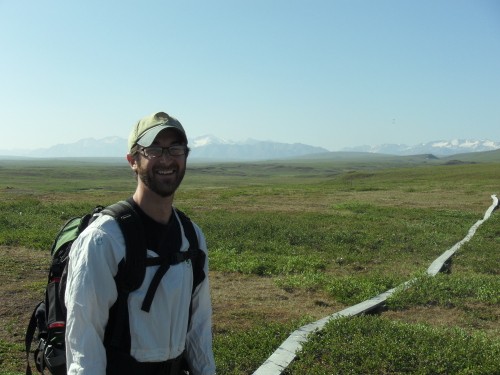 Nate Healey at the boardwalks
are spending their summer in the Arctic, as opposed to their winter residence at Florida International University in Miami, Florida. They are part of a large Arctic climate research project called ITEX-AON. I know, fun acronyms, right? This one stands for International Tundra Experiment, Arctic Observation Network. You can find out more about this project and their Principal Investigator, Dr. Steve Oberbauer, at their project website AON-ITEX project
Arctic regions are experiencing much faster responses to climate change than the lower latitudes. Maybe it's not in the news so much, since so few live up here, but the climate change occurring here can have some pretty serious consequences for the rest of us. Scientists are trying to better understand the mechanisms that control tundra ecosystems; for example on our project we are looking at nutrient cycling and the role nitrogen plays in limiting plant growth and decomposition. The concern is about the large stores of carbon in the soils in these latitudes, and how climate change and especially warmer temperatures are going to precipitate higher releases of CO2 into the atmosphere. Just recently, a milestone in atmospheric CO2 was reached here in the Arctic, normal atmospheric concentrations of CO2 run about 380 - 400 parts per million, and recent measurements across the Arctic were above 400.
Back to our Trolley!
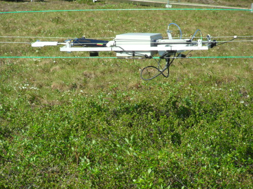 the NIMS at cruising altitude
This flattish box affair suspended from cables is chock full of sensors
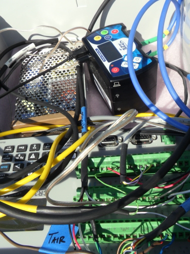 the guts of the sensor network
It's got fiber optics that measure reflectance, which is information that tells scientists about the structural properties of the vegetation, for example if the vegetation is primarily shrubs or grasses. The cool box connected to the fiber optic cables is a spectrometer, the JAZ module from Ocean Optics. It is hypothesized that as warming in the Arctic progresses, the tussock-tundra and dry heath areas may become shrubbier. The consequences of that are a whole 'nother can of worms. Shrubbery can hold more snow, keeping the ground warmer and more insulated; it can transform the landscape into a less reflective surface, holding more heat, etc. Then there is a host of consequences for the animal life we are so used to seeing in these habitats here, including well known animals such as the caribou, polar bear, and songbirds, and also the suite of other animals and plants, some microscopic, going about their daily business holding the ecosystem together.
Another sensor is mounted that measures greenness, called the NDVI, the normalized differentiation vegetation index. Farmers use NDVI sensors too, to calculate the current water and fertilizer needs of their crops. We have these sensors on our snowmelt plots, also, mounted on the neat arrays that hold our sensors called mantises. Knowing the extent of greenness helps scientists calculate rates of photosynthesis, which in turn, if you read the journal about ecosystem respiration, indicates how much CO2 gas exchange is occurring. The cool thing with a bubble on top at the front of the sensor platform is a net radiometer
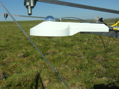 infrared sensor on the NIMS
which measures short and long wavelengths of light coming in from the Sun and being reflected back from the Earth. This gives real-time information about amounts of heat coming and going. Directly behind that is a 3D video camera taking regular pictures you or I can recognize. Another sensor mounted on the box is a sonic distance sensor, which is constantly measuring the distance from the sensor array to the top of the plants. This gives the researchers topographical knowledge of the sampling area, which helps in interpreting sizes of plant. Of course, temperature and atmospheric conditions are always important to know, so additional sensors record surface temperature and temperature at the body of the array, making the correction for the heat generated by the sensors on board. For good measure, a camera is also mounted on the tower; it takes pictures every 15 minutes of what's going on around it.
 Plant cam mounted on tower
Prior to sending the trolley off, Nate will also take a series of pictures comprising a 360 degree view of the sky at time of data collection. That way, there is no question as to how clear or how partly cloudy it was. The whole set up is powered by our good ol' Sun, complete with battery storage and DC to AC current conversion, check out the earlier picture of Jose with the solar panel. Here's the inside of the storage box
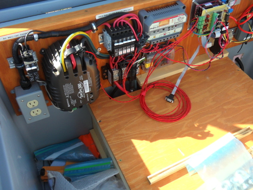 battery supply box to store solar power and convert it from DC to AC
As they (might) say, that's a whole lot of sensing going on! What are these scientists doing with this information? Great question! In order to know if something has changed, we need to know what its current state and past history is. This AON project is collecting baseline data across the Arctic in order to better understand what and how things are changing. The cool thing about the trolley is that it can gather a huge amount of information in a very short time; much of this data is currently gathered by hand. I asked Nate what the time savings is….he estimates that the hour round trip time of the trolley is comparable to a long day or even two of work done in human time. As large as the Arctic is, being able to gather data from multiple locations in a shorter amount of time will help to really advance the baseline database needed to better understand effects of climate change. At this time, Nate and his team have deployed the trolley sensor arrays in about a half dozen locations north of the Brooks Range. The route the trolley is currently set up to take crosses tundra that includes dry heath, tussock tundra, and also a water track. Water tracks typically have the lushest vegetation, and you can read more about them in Melissa Barker's journals at Nutrient Transport in Arctic Watersheds It's great that the sites are set up to take advantage of different vegetation types, even over their relatively short runs of 50 meters.
The Toolik trolley is the perfect subject for a video, I think; here is a short clip so that you can see it in action
Jose is working on his Master’s thesis project that examines how dwarf birch can respond to environmental heterogeneity through shifts in the shrub’s architecture. He is creating 3D representations by actively digitizing representative dwarf deciduous birch shrubs, Betula nana. His device is called the Polhemusa Fastrak, which is used to scan three dimensional images in real time.
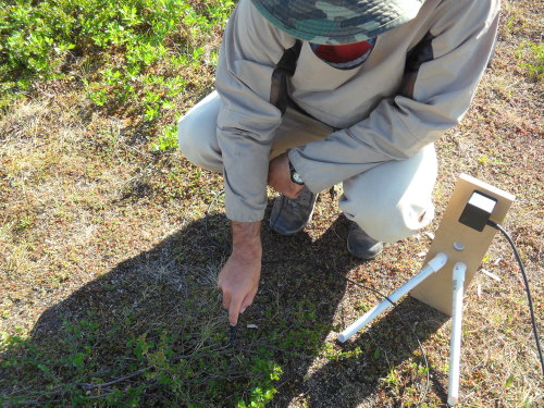 Jose with the Fastrak transmitter
Basically, it's a transmitter that sets up a magnetic field. He then uses his clicker, which acts as a receiver, to click and outline the stem and leaves of the entire plant. This is a time-consuming process requiring some concentration and a steady hand.
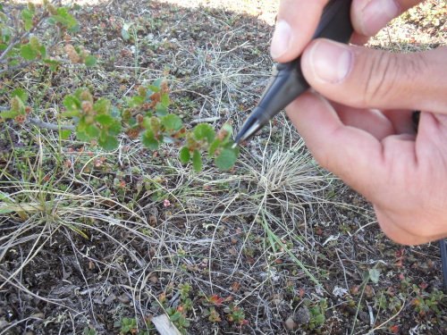 Jose's clicker pen he uses to generate a 3D image of the plant
The three dimensional figures he is able to compose with the digitizing process are truly amazing
 3D image of Betula stem digitized by Jose Luciani
and after he measures the photosynthesis rates, he will have information critical to the scaling up process of understanding whole plant performance in a changing environment. An interesting side question that he is studying is to discern differences in Betula that are growing in a prostrate, spread out manner, as opposed to an upright growth structure (the architecture of the shrub). Jose would like to find out if the different structural forms are caused by a genotypic difference and/or phenotypic plasticity responses to environmental factors. For a low tech start on this, he will be collecting seeds from the birches, planting them, and looking at their structural growth patterns. Much as Mendel did with his breeding of pea plants, Jose will be able to figure out genotypes through breeding of generations of these birches.
Nate prefaced each run with a voice recording stating the start time, location, and date of each launch. He called the NIMS at Toolik Field Station the Toolik Trolley. However, when I tagged along with him to his Imnaviat site, he said he had not yet named the trolley there. I suggested we call it the Starship Healey, which seemed perfectly appropriate given its overall looks and the log-like sounding entry he gives at the start of each run. I really enjoyed my day out with these scientists from the ITEX_AON project. It was great to learn about the technology they are employing to obtain information on environmental conditions in the Arctic, and I was really psyched to see their dedication, professionalism and good humor, as well as their enthusiasm for the beauty of the Alaskan tundra
 Nate Healey, myself and Jose Luciani at the trolley site

Add new comment