 The TransAlaskaPipeline off the Dalton Highway
What's big, round, and almost always in sight? A near constant companion is the Alaska Pipeline, owned and operated by the Alyeska Pipeline Service Company. In fact, if it weren't for the pipeline, we at Toolik Field Station might not be here today.
After oil was first discovered in Prudhoe Bay and other locales along Alaska's North Slope in 1968, it was eventually determined that the best way to transport the oil from there to Valdez, the northernmost ice-free port in Alaska, was to construct a pipeline.
 map of TransAlaskaPipeline, courtesy of Wiki-pedia Commons
By the way, our location on that map is between Pump Stations 3 and 4.
The construction of the Transatlantic Pipeline System (TAPS) began in March 1975, and was completed in June of 1977. The 800 mile pipeline was built after major controversy and opposition by environmental groups; much of it was originally planned to be buried in the permafrost. Many studies were done to determine the impacts and mitigate them, among them some 15,000 soil samples determining areas of permafrost. Final permits for the pipeline came after the Arab Oil Embargo of 1973 caused the price of gas at the pumps to jump from 30 cents per gallon to $1.20 per gallon. The pipeline was built at a cost of around 800 billion dollars with many innovative features to lessen negative environmental impacts of a road and pipeline. It traverses sensitive wildlife habitats, is built on permafrost susceptible to melting, crosses over at least one earthquake fault line, and crosses three major mountain ranges and over 43 rivers or streams. Amazingly, the end result has been a fairly trouble free pipeline, due to some innovative engineering. Construction included wildlife crossings
 a spot where the pipeline is buried for wildlife to cross over
refrigerated and insulated portions of pipe, a heat removal system that automatically removes heat from the ground, and zig zags built into the pipeline to allow it to expand and contract
 zig-zag of pipeline to allow for expansion and contraction
The peak of oil production and movement came in 1988; new issues of low flow are on the horizon for the pipeline. Unfortunately, there have been some damaging incidents; one of the most recent was a 250,000 gallon spill in 2006 on land near Prudhoe Bay, and of course the famous Exxon Valdez spill of 1989, related to the pipeline in that it was a ship carrying oil away from the port at Valdez.
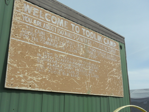
But I digress. What does the pipeline have to do with Toolik Field Station? Well, to transport construction goods to and from the pipeline, a road needed to be constructed, originally called the Haul Road, and now called The Dalton Highway. A question came across the Ask The Team forum about the origin of Toolik Field Station. Basically, the field station originated due to the presence of the Haul Road and construction of the Alaska pipeline. Back in 1975, Toolik Camp was a construction camp for the haul road.
 Historic Toolik Camp sign
Just as the road was being completed, some researchers in Barrow, AK were looking for a new lake to study, one that was fairly large and did not freeze solid in the wintertime. They traveled along the road looking for a Murphy Lake, when they happened upon Toolik. A few tests of the lake confirmed it was just what they needed, and a couple of trailers later a research station was born.
 Toolik Field Station first located on the runway of Toolik Camp
A frequent visitor to the station here is Mike Abels, whom I've had the great pleasure to meet. He is the Field Operations Manager of Toolik Field Station.
 Mike Abels, Field Operations Manager for Toolik Field Station, leading a tour
Several years ago, he relayed a history of Toolik Field Station through a series of interviews. I got much of the previous information from Section Two of the interview. These are on file now at The Dalton Highway: A Multi-Media History of Alaska's Arctic Road link. I thoroughly enjoyed listening to the interview, and you will too. Listen closely for the side story about Murphy Lake!
I hope you've enjoyed learning a little more about our constant companion, the Alaska Pipeline, and the history of how Toolik Field Station came to be.
 the pipeline viewed from camp, just a silver line in the distance
For more information, feel free to check out some of the very interesting resources I ran across:
(http://www.alaskastock.com/Alaska_Pipeline_Photos.asp)
(http://en.wikipedia.org/wiki/File:Trans_alaska_international.jpg)

