Update
Now Archived! PolarConnect event with Sarah Slack and Dr. Frank Nitsche from aboard the R/V Nathaniel B. Palmer in West Antarctica on Monday, 9 March 2020. You can access this and other events on the PolarConnect Archives site.
What Are They Doing?
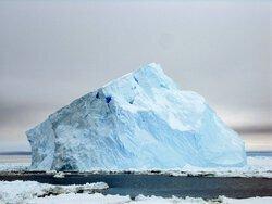 A sloped blue iceberg. Aboard the icebreaker Oden between the Amundsen and Ross seas. Photo by Lollie Garay.
Satellite observations show that Thwaites Glacier, West Antarctica, has been thinning rapidly and its flow speed has been increasing. At the same time, its grounding line, the point at which the glacier starts to float over the sea, has retreated. Oceanographic studies show that the main driver of these changes is incursion of warm water in the deep ocean beneath the floating ice shelf that extends seaward from the glacier. An important factor affecting the flow of warm water towards the glacier and the stability of the ice shelf is the topography of the seafloor in the area, which is poorly known. The seafloor offshore from Thwaites Glacier and the records of glacial and ocean change contained in the sediments on it are the focus of the THOR project.
Where Are They?
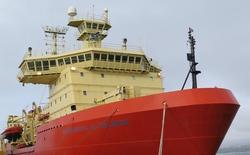 The Nathaniel B. Palmer research vessel docked in Punta Arenas, Chile. Photo by Jillian Worssam.
The team will be aboard the R/V Nathaniel B. Palmer icebreaker in the Amundsen Sea, West Antarctica near Thwaites Glacier. Normally, participants onboard the Nathaniel B. Palmer share a two-person cabins with bathrooms on board the boat. Regular meals will be provided by the ship's crew. Work will be in labs on board and, possibly, on deck.
Latest Journals

Frank O. Nitsche received a MS in geophysics from the University of Kiel, Germany and a PhD from the University of Bremen, Germany. In 2001 he came to the Lamont-Doherty Earth Observatory of Columbia University where he started as a postdoctoral researcher and is now a research scientist. There he studies sediment processes and morphological conditions of the Hudson River Estuary and the Long Island Sound. In addition, he investigates the morphology of the Antarctic continental margin and is reconstructing the path of past ice streams and related sediment transport processes. He has participated in six expeditions to Antarctica and its surrounding Southern Ocean where he used acoustic mapping techniques and oceanographic measurements to understand past and present processes that shape the Antarctic continental margins and affect the ice sheet. He is involved in the creation of the International Bathymetric Chart of the Southern Ocean. Read more about Dr. Nitsche here.


